Burst of snow to streak over St. Louis to DC, Philly


The second of two storms this week will travel farther south than the first and has the potential to bring snow and slippery travel from the central Plains to the mid-Atlantic coast through Saturday morning, AccuWeather meteorologists warn.
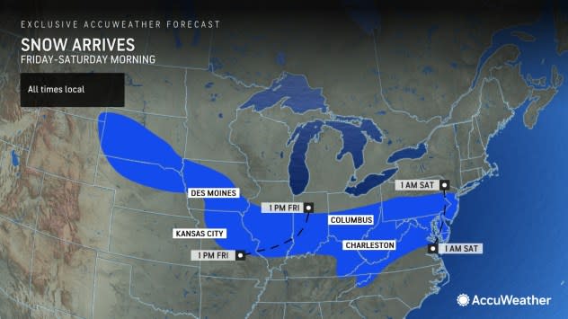
This storm will continue to move across Nebraska and Kansas before reorganizing farther to the south over the central Plains and middle Mississippi Valley into Friday morning in response to a push of colder air.
 |
"As all clippers do, the storm will be moving quickly, with much of its limited moisture tapped from the Pacific," Bauer explained. He added that clippers are quick-hitters and don't produce prolific snowfall but can still cause travel disruptions.
Exactly how far north or south this reorganization occurs will determine the storm track as the strip of 1-3 inches of snow with locally higher amounts advances across the Ohio Valley, central Appalachians and the mid-Atlantic coast.
 |
"Commutes between Omaha, Nebraska, and St. Louis can be impacted on Friday. Then travel can be impacted in the Ohio Valley to mid-Atlantic Friday evening to Saturday morning," Bauer said.
Slippery conditions from snow are likely in Cincinnati and Pittsburgh on Friday night.
As the storm rolls across the higher terrain of the Appalachians in West Virginia, western Virginia, western Maryland and far south-central Pennsylvania, more snow is possible with 3-6 inches in some locations. Charleston, West Virginia, is among the larger cities that may get enough snow to shovel and plow from the storm Friday night.
 |
There is some potential for the storm to strengthen upon nearing the mid-Atlantic coast late Friday night to Saturday morning. If this occurs, it could turn slightly to the north rather than continuing east and tracking out to sea.
Washington, D.C., Baltimore, Philadelphia, Dover, Delaware, and Atlantic City, New Jersey, are currently in the path where 1-3 inches of snow will likely fall. A small amount of accumulating snow may extend as far to the north as New York City and as far to the south, in wintry mix form, to Richmond, Virginia.
Most of the snow will likely fall in 6 hours or less. During that time, the snow may fall at the rate of 1-2 inches per hour in a narrow zone. If near Washington, D.C., Baltimore, or any other area east of the Appalachians, 6 inches of snow could pile up quickly.
 |
An increase in strength and slower speed may also allow the storm to tap more moisture from the Atlantic, resulting in heavier snow. A slightly stronger storm may also tug warmer air farther to the north and lead to rain instead of snow in part of the mid-Atlantic, such as the Delmarva Peninsula and southern New Jersey.
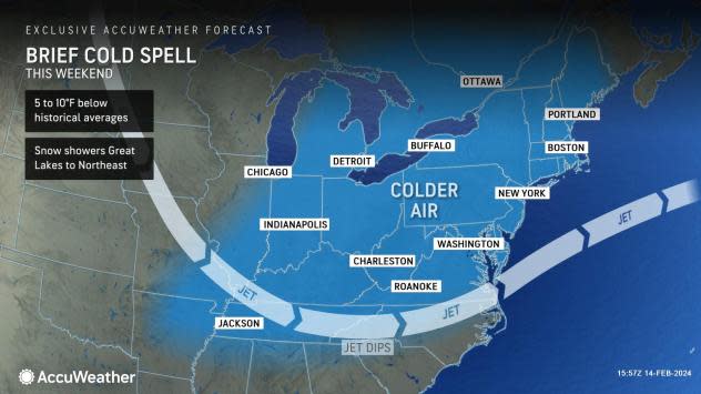
As a result of the cold push in the wake of the big storm from Tuesday, roads and sidewalks are at their coolest point, and snow may have an easier time making paved areas slippery.
Motorists and airline passengers should expect delays from late Friday night to Saturday morning in the Interstate 81 and 95 corridors of the central Appalachians and mid-Atlantic. Aircraft will likely need to be de-iced, and some flights could be canceled.
 |
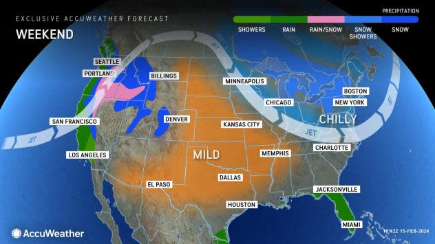
Just as the first storm will push chillier air farther south to end the week, the second storm will feature a bigger and colder push of Canadian air in its wake for much of the weekend in the Midwest and the Northeast.
The fresh snow will begin to melt on Saturday afternoon in the wake of the late-week storm. Any lingering damp areas will freeze at night from the Ohio Valley to the mid-Atlantic. People heading out Sunday morning should beware of possible icy patches.
Want next-level safety, ad-free? Unlock advanced, hyperlocal severe weather alerts when you subscribe to Premium+ on the AccuWeather app. AccuWeather Alerts™ are prompted by our expert meteorologists who monitor and analyze dangerous weather risks 24/7 to keep you and your family safer.
