ByGone Muncie: Railroad helped DeSoto overtake Clinton as center of Delaware County
MUNCIE, Ind. – On Jan. 15, 1881, a Delaware Township landowner named Luther L. Perdieu filed a plat with the county recorder for a new village named Woodlawn. The community was to sit along Campbell Creek about a mile south of the Mississinewa River.
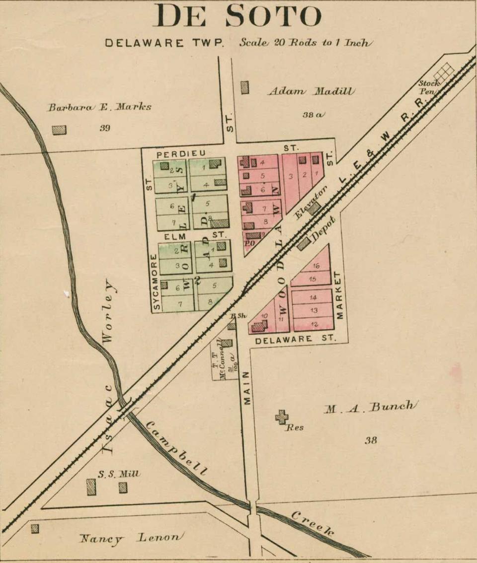
Perdieu was developing land around the new Lake Erie & Western Railroad depot being built in the southeast corner of Delaware Township. He divided his fledgling village into sixteen lots and ran them along either side of the track.
Choosing the name ‘Woodlawn’ was likely a nod to the area’s dense forests, though much of it was being cleared at the time. The Muncie Daily News wrote on February 28 that “two small mills are now in active operation there and at least one hundred car loads of lumber are ready for shipment.”
The paper concluded that Woodlawn “will doubtless in time become a town of no mean pretensions.” Two months later, the village was “rapidly assuming the proportions of a town. A store room is nearly complete, a blacksmith shop has been built and several buildings of greater or less magnitude are in the course of erection.”
Perdieu ran into a problem when he applied for a post office. The U.S. Post Office Department rejected the name ‘Woodlawn’ because it too closely resembled Woodburn P.O. in Allen County. The U.S. Post Office didn’t allow two P.O.’s with identical or similar names to exist within the same state. Undaunted, Perdieu refiled for a post office named ‘DeSoto.’ There’s no contemporary source I could find indicating why he chose that name, but the historian and folklorist Ronald Baker wrote in 1995 that it was an homage to the Spanish conquistador.
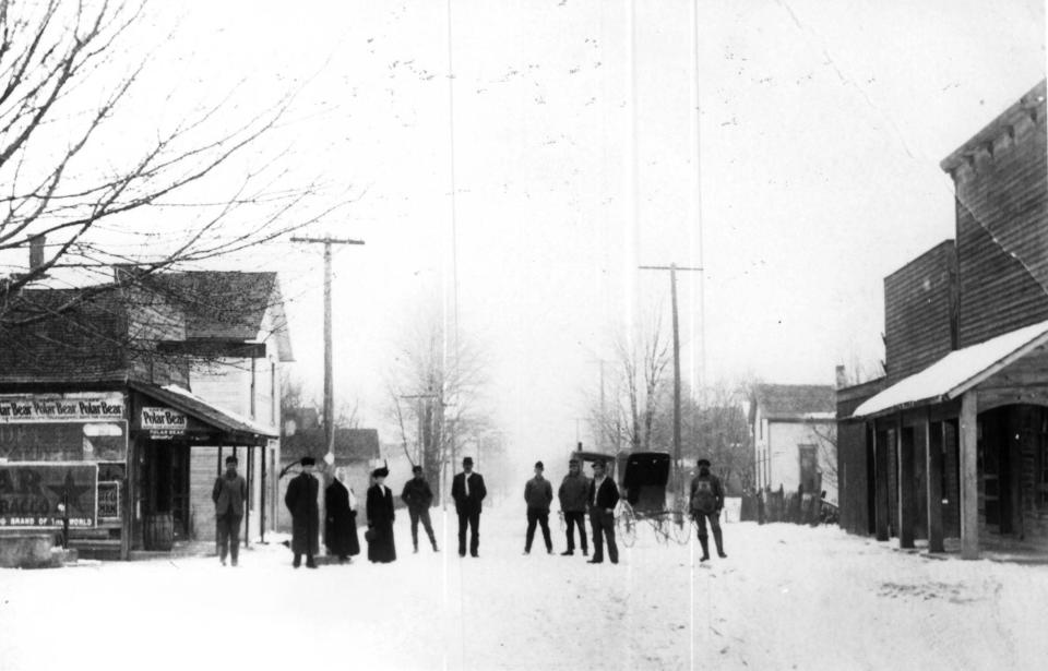
DeSoto grew in the waning years of the 19th century. In 1883 a township landowner named Isaac Worley filed a plat to extend the village west by adding sixteen additional residential lots. Local historian G.W.H. Kemper wrote that by year’s end, DeSoto comprised “three stores, a depot, warehouse, blacksmith shop, shoe shop, two sawmills, two carpenters, a doctor” and a population of “thirteen families.”
The lone doctor was Robert A. Bunch, who, in the 1880s with his wife Mary, raised five kids on a farm just south of the village. Their son Rollin Havilla later became mayor of Muncie.
A suburb of sorts named ‘East Muncie’ was platted immediately north of DeSoto in 1893. East Muncie was a speculative development by the East Muncie Land Company to lure a paper box factory. The company, which in some sources was identified as East Muncie Mantel, was incorporated with $25,000 stock and led by Francis and George Pittenger, Adam Madill, and James Leavel.
The Muncie Morning News reported in January of 1893 that East Muncie Land Co. was in final talks with “Boston capitalists” for a plant that would employ 250 workers. The developers also planned “twenty-five double residences and a boarding house with a capacity to accommodate sixty customers.” They also drilled a gas well in anticipation of the factory.

According to the News, DeSotoans supposedly were “jubilant over the acquisition to their village and are celebrating the occasion right royally.” I’m not so sure I believe this. When companies like Muncie Pulp and West Muncie Strawboard moved to Delaware County during the gas boom, they located on Buck Creek to easily discharge toxic waste. Such practices were royally hated by farmers living downstream from such polluters. I suspect the plan for East Muncie’s box factory was to dump directly into Campbell Creek.
Luckily it never materialized and East Muncie Land Co. went bankrupt after the Panic of 1893. Kemper wrote that several “Delaware County citizens lost money” in the company's collapse. The Evening Times later reported that the “plans laid out for building a town and carrying on a large industry did not materialize and the result is the appointment of a receiver.”
Since DeSoto didn’t actually exist, in a legal sense, East Muncie eventually just became part of the village. Unlike a town or city, with legally defined borders and an elected government, DeSoto was an informal community with no clear boundaries. Everyone just sort of understood where it was and who lived there.
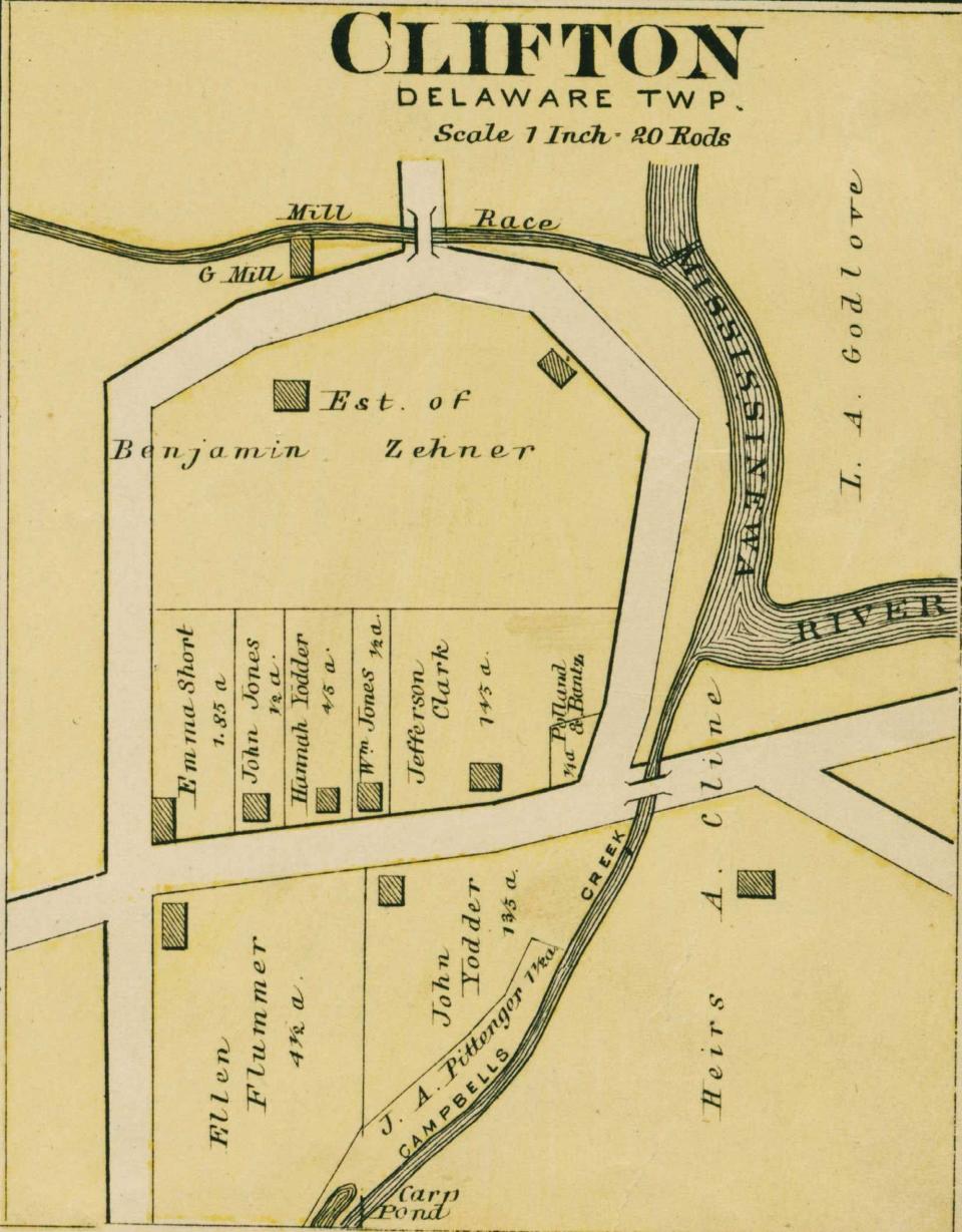
A mile north of DeSoto sat the old hamlet of Clifton, where Campbell Creek meets the Mississinewa River. Clifton grew in the pre-Civil War years to become a small agricultural processing and trading port centered around mill activity. A squatter named John Boyles built the first mill here in 1830. Four years later, Granville Hastings excavated a race and erected a sawmill west of the river bend. Benjamin Zehner bought the site twenty years later and built a three story mill in 1864.
Somewhere in the 1840s, a dirt road was cut between Muncie and the village of Granville, by way of Clifton. At its height in the 1860s, the hamlet had a blacksmith, a few houses, and the Zehner Mill. A post office operated in Clifton from 1853 to 1884, although it was called Sharon (a Clifton P.O. in Union County already existed).
I’m not certain of this, but I reckon the reason Lake Erie and Western Railroad bypassed Clifton a mile south was to keep clear of Mississinewa’s floodplain. All of Clifton was in it. The railroad’s decision rang the death knell for the hamlet, as did occasional but devastating floods. The trains also ended riverboat traffic down the Mississinewa, as farmers opted to ship via locomotive. Over time, the mills steadily lost business and by the end of the century, Clifton had all but disappeared.
DeSoto, however, continued to thrive in the 20th century. In 1905, the Muncie and Portland Traction Company completed a route through the village. The line in 1916 became part of Union Traction’s Interurban system. Many DeSotoans found work at Indiana Steel and Wire in the early 20th century, commuting to the Muncie factory via Interurban. Then in 1908, a new school opened as a consolidation of several Delaware Township schoolhouses.
DeSoto is probably best understood as a successor settlement to Clifton. The center of population and commercial activity in that corner of Delaware Township, such as it was, had moved south a bit to drier land with the arrival of the railroad. Though nothing remains of the original Clifton today, it didn’t exactly die. It has lived on as the charming little village of DeSoto, Indiana.
Chris Flook is a Delaware County Historical Society board member and a Senior Lecturer of Media at Ball State University.
This article originally appeared on Lafayette Journal & Courier: ByGone Muncie: Clifton never died, the origins of DeSoto, Ind.

