ByGone Muncie: A New Y for Wysor’s Bottoms
MUNCIE, Ind. – I was delighted to see Muncie’s YMCA recently launch a capital campaign for a new facility. As one of our city’s longest running organizations, the new building will better help the Y thrive well into the 21st century.
I’ve been a YMCA member for three decades and have the venerable institution to thank for my chiseled physique and washboard abs. Ok, that last part is a lie, but Muncie’s YMCA has certainly given me a better body, mind, and spirit over the years. My first Y memory was learning how to swim at the downtown pool in the mid-1980s. Twenty years later I took scuba lessons from Tom Leaird at this same natatorium; a right of passage for any true Munsonian.
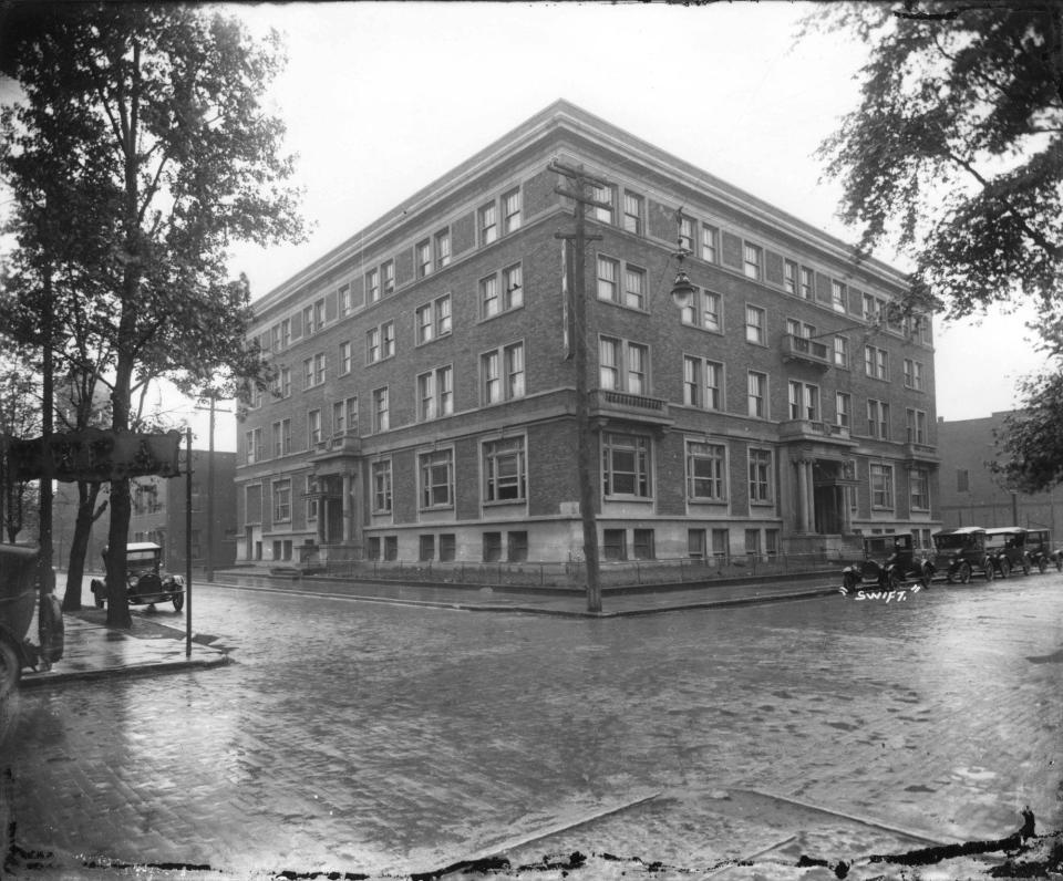
Our forebears established the local YMCA in 1875. The generation that followed erected the first building at the southwest corner of Adams and Jefferson streets in 1913. Southsiders surely also remember the Madison Street YMCA mid-century. In recent decades, the Y added modern spaces, including a new edifice on Mulberry Street in 1975, the Chadam Lane complex in 1985, and the Yorktown facility in 2010.
The plan I’ve seen puts the new Y just south of Central and a half block north of the Field House. Munsonians of a certain age might recall that this location was home to McKinley Junior High from 1939 to 1990. Prior to the school, the Grouleff & Mauck Lumber Co. retailed timber approximately at the same place in the early 1900s.
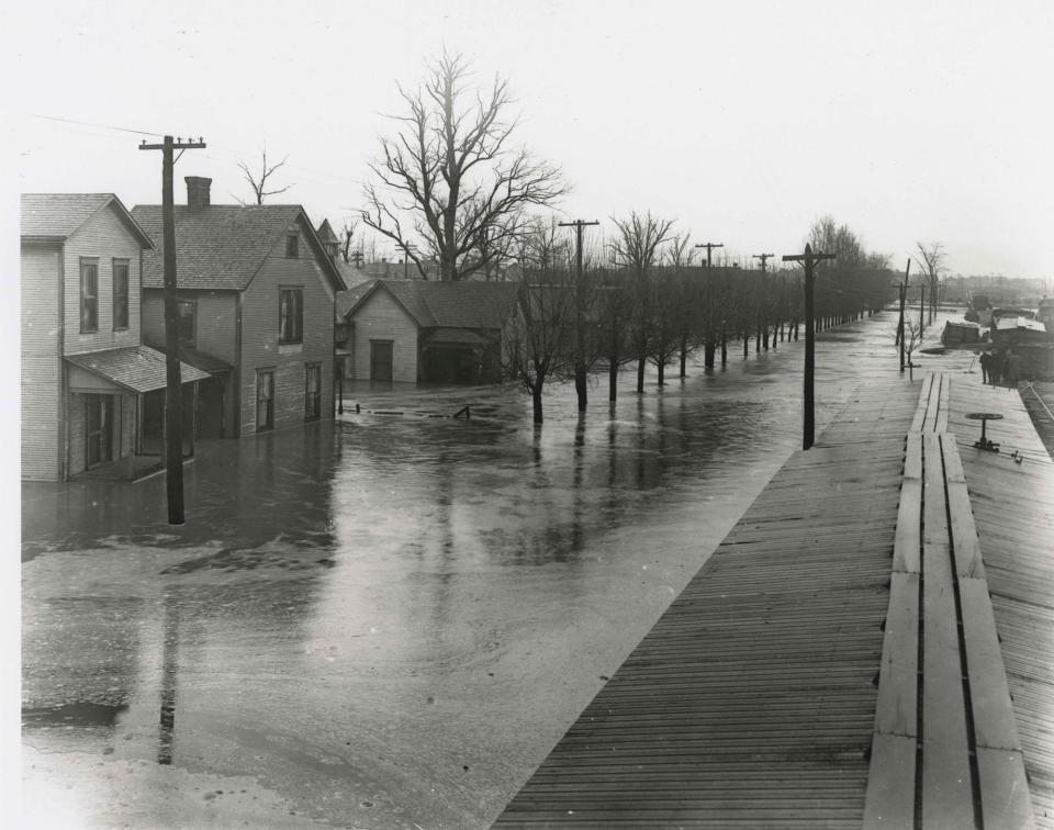
Along with the McKinley Neighborhood and part of East Central to the east, this section of Muncie within the bend of the river and north of Wysor Street was known historically as either Wysor’s Bottoms or the Low North End. The area was flood prone prior to the 1950s and developed slowly.
When Lenape Native Americans arrived here in the 1790s, the Munsee speakers lived at a village on the bluffs overlooking the bend at what is now Minnetrista. They wisely chose dry ground well above the floodplain, though their cornfields were south inside the fertile bend.
The Lenape were living on ancestral Myaamiaki land, some of which was reserved for descendents of Chief Mihšihkinaahkwa (Little Turtle) in the 1818 Miami Treaty of St. Mary’s. One of those heirs was Rebekah Hackley, Little Turtle’s granddaughter. The treaty granted Hackley a square mile of land, 320 acres north of the bend and 320 south. The area today is bounded by the aptly named Reserve St, Centennial Ave, Martin Luther King Jr. Blvd, and the alley between Main and Washington streets.
Hackley sold her reserve to a trader named Goldsmith Gilbert, who had settled here around 1821. He first lived in Perry Township and then opened a trading post along the Mississinewa southeast of present day Eaton. In 1825 he agreed to buy Hackley’s Reserve for $960, although he didn’t pay Rebekah until a judge ordered him to do so a decade later. With fellow settlers Lemuel Jackson and William Brown, Gilbert donated land to establish Muncietown as Delaware County’s seat of justice in 1827.
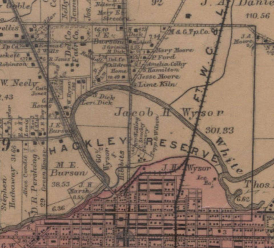
Had Gilbert been a farmer, he might have developed the village on the same flood-free bluff where the Lenape had theirs. Gilbert, however, was a prototypical industrialist. In the late 1820s and 1830s, he built out a center of commercial activity around what is today Wysor and Walnut. He constructed and operated flour and saw mills, a woolen factory, distillery, dry goods store, hotel, and blacksmith. His house stood where American Legion Post #19 is now.
Gilbert used water to power his mills, derived from a race he dug around 1830. Race Street was so-named as an homage to this. The channel’s inlet began at the river where the Wysor Street/MLK Jr. Blvd bridge is today. The race flowed west and then split into two runs at what is now Walnut Commons. I don’t understand the reason for the north run, as no mills existed on it. Whatever the purpose, it ran west to where the Field House is today and emptied into the river near High Street’s Fallen Heroes bridge. The south channel flowed generally in the same direction and powered mills around Walnut and High streets, including Gilbert’s and Wysor & Hibbet’s. It continued southwest and emptied into the river just beyond Franklin Street. The race’s east end and north channel were filled during the gas boom, while the south channel was covered and became a sewer in the early 1900s.
In the pre-rail era before 1852, the mill race is probably best understood as Muncie’s first industrial center. In addition to the mills and distillery, a tannery, grain elevator, slaughter house, and stock yard operated along the race. When new railroads arrived in the late 19th century, they formed a spaghetti mess of tracks east of North Madison. A spur known as the ‘Jerusalem Track’ was added to service the mills and lasted until the late 1960s, bringing coal to I&M’s steam plant. During the gas boom, the city ran a garbage furnace along North Walnut in the bend and a gas-fired power plant at the northeast corner of Madison and Wysor.
After Gilbert died in 1844, his heirs sold most of his land to Henry Wysor, another early industrialist. In recognition of the change in elevation, the area northeast of the bend became known as Wysor’s Heights and the land south, Wysor’s Bottoms. The Bottoms’ residential area between Walnut and Madison was platted in 1893 as Whitely Land Company’s Second Addition to Muncie, though we know it today as McKinley Neighborhood. The district was named after McKinley School, which opened at 600 N. Mulberry Street in 1906. Around this same time, an Interurban line ran down Mulberry, heading to Hartford City and points north.
Due to frequent and severe flooding, the west end of Wysor’s Bottoms developed much more slowly. In early years, the Bottom’s northwest quarter (Muncie Central today) was often used as a cow pasture. From 1923-1952, it was home to the Minnetrista Golf Course.
Around 1900, the North Walnut Athletic Park was near where Central’s new stadium is currently being built. The park hosted hundreds of amateur and semi-pro baseball and football games in the late 19th and early 20th centuries. It was also home field for the Muncie Flyers during their brief and disastrous 1920 and 1921 NFL seasons. And of course, the historic Muncie Field House was completed in 1928.
Flooding stopped in Wysor’s Bottoms after the Army Corps of Engineers completed the levees in 1950. At the time, the YMCA owned Minnetrista Golf Course, which they sold to Muncie Community Schools in 1952. MCS opened a new high school building on the site in 1974.
I’m excited for the YMCA’s new home at a place with such a rich history. I look forward to the Y being in the very heart of Muncie and at the center where it belongs.
Chris Flook is a Delaware County Historical Society board member and a Senior Lecturer of Media at Ball State University.
This article originally appeared on Muncie Star Press: ByGone Muncie: A New Y for Wysor’s Bottoms

