Calgary was warmer than Miami the Christmas it snowed in Florida
Calgary was warmer than Miami for a few days during a memorable cold snap that blanketed eastern North America in December 1989. Parts of the Sunshine State even saw their first-ever white Christmas during the chill.
The winter solstice arrived in style that year. A blast of Arctic air slid out of Canada with such force that it careened into the Gulf of Mexico, sending a rare dose of winter to visit snowbirds who flocked south to escape its frosty grasp.
The late-December cold snap of 1989 is a rarity in weather history not just because of the extreme cold—and the wild temperature gradients—that blanketed North America, but for the tremendous snows that fell across typically temperate vacation spots.
DON’T MISS: 12 weather stories of Christmas past
It’s exceptionally rare for Calgary to come in warmer than Miami—but if any cold outbreak could do it, the frigid wave that crested over eastern North America near the end of December 1989 certainly fit the bill.
The saga started when the heart of the polar vortex moved over the eastern Prairies a week before Christmas.
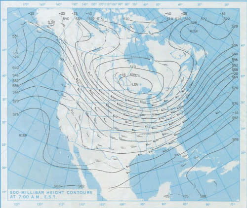
A chart showing the upper-level low over Canada on December 18, 1989. (NOAA/NCEP)
This upper-level low dragged some of the world’s coldest air over Manitoba and northwestern Ontario, with temperatures at daybreak on Monday, December 18, easily falling below -30°C across a huge swath of the region.
Frigid temperatures only got colder the following day, with -40s popping up on the board in Fort McMurray, Alberta, and sections of rural Saskatchewan.
Our pool of dangerously cold air didn’t stay put for long. The upper-level pattern kept moving as we crossed the winter solstice, allowing a polar cold front to race south of the border and shove bitter temperatures deep into the United States.
Stiff northerly winds sliced as far as the Gulf of Mexico. Folks in Dallas, Texas, braved a daytime high of just -10°C on Dec. 22, with a ridiculously cold low temperature of -18°C the next morning—16 degrees below their normal low of 2°C for the date.
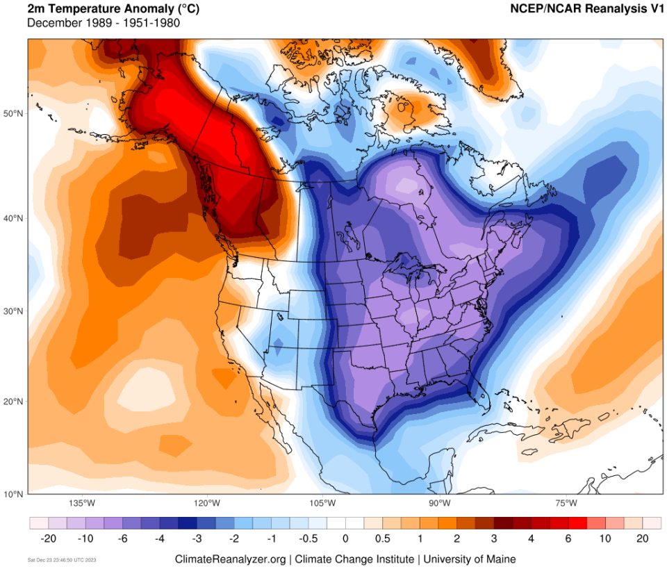
A chart showing the extent of the colder-than-normal temperatures that blanketed eastern North America in December 1989. (NOAA/NCEP via ClimateReanalyzer.org)
MUST SEE: Seven times weather unexpectedly changed the course of history
The trough responsible for this Arctic intrusion had another trick up its sleeve. A secondary low-pressure system developed over the Gulf of Mexico as the cold air dove south, helping to drag the frigid air all the way to southern Florida.
Enhanced by that developing winter storm, frosty winds kept the city of Mobile, Alabama below freezing for two days straight—one of the longest such streaks on record.
Extremes beget extremes. A steep trough over the east allowed a formidable ridge to build over the west. This setup, along with downsloping winds off the Rockies, kept Calgary warmer than Miami on both Christmas Eve and Christmas Day. Temperatures at 7:00 a.m. on Christmas Eve came in at 1°C in Miami and a relatively balmy 6°C up in Calgary.
“State of Emergency Called as Florida Freezes,” read the story’s headline in the New York Times’ issue on Christmas Day. The article, syndicated from the Associated Press, noted that Miami plunged below freezing on Christmas Eve and that Orlando’s staggering wind chill of -20.5 came in colder than the wind chill up in Minneapolis.
But for many, the historic cold snap took a backseat to the unprecedented snows that soon followed.
The developing winter storm over the Gulf of Mexico had unfettered access to ample Caribbean moisture and unlimited Arctic air to its north, setting up an exceptionally rare winter storm across the southeastern coast.
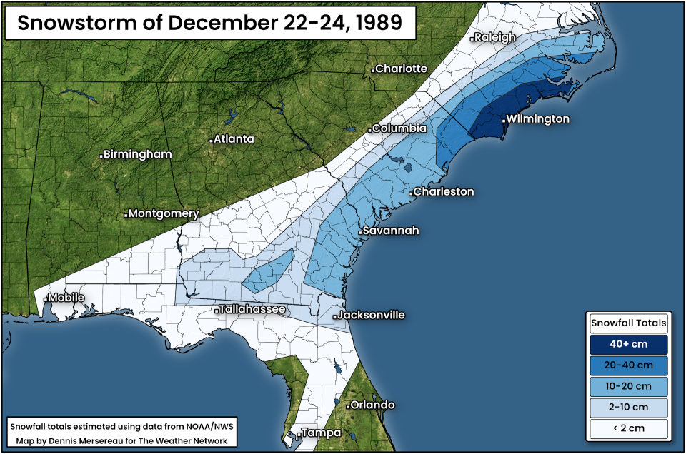
Accumulating snow fell throughout northern Florida. Ice pellets were reported as far south as Tampa. Jacksonville Beach woke up to 6 cm of snow on the ground by December 24, and temperatures were cold enough for the snow to stick around in spots until Christmas morning—the first-ever white Christmas recorded in Florida.
Folks across the coastal Carolinas saw their largest snowstorm ever recorded. Charleston, South Carolina, measured 20 cm of snow by the end of the storm, and more than 50 cm of snow fell near Wilmington, North Carolina.
The Christmastime cold snap of 1989 remains the last time Miami’s official temperature fell below the freezing mark, and the most recent occasion Jacksonville saw measurable snowfall.

