California braces for major storm: Flooding, snow, winds possible in LA, Sierra, Sacramento
A dangerous, intense storm is expected to slam into California, bringing the potential for widespread flooding in Southern California, mudslides and debris flows along the coast and in the Bay Area and heavy snow to the Sierra.
Kicking winter into high gear, the storm could bring record-breaking precipitation across the state, but the impacts won’t be the same, experts said Friday. Strong winds could cause power outages on Sunday in the Sacramento region and elsewhere, and the rain is likely to back up storm drains and cause minor flooding on local creeks and some roads.
Rain was expected to begin falling in Northern California on Saturday evening, primarily along the coastal Bay Area, the result of the second atmospheric river to reach the state in less than a week.
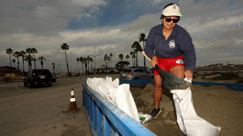
The Governor’s Office of Emergency Services has deployed personnel and resources to many areas in the path of the storm, including more than 550 firefighters and 19 swift-water rescue teams in 19 counties, officials said. Two million sandbags have been pre-positioned across the state.
“As we look ahead to the next few days, we encourage all Californians to take steps now to prepare for incoming weather,” agency spokeswoman Alicia de la Garza said in a video posted on X.
Local, state and federal officials are urging caution during the most treacherous periods of the storm Sunday and Monday.
Almost statewide, communities are preparing for heavy rain through Tuesday, with 94% of the population — an estimated 37 million people — at risk for floods, according to an analysis from AccuWeather that reviewed already soaked areas forecast to get 2 or more additional inches of rain.
Gov. Gavin Newsom said Friday that “California has more than 8,300 boots on the ground as we prepare for this next set of serious storms.” He cautioned all in the storm’s path — especially those in Southern California — to prepare now and follow the guidance of local government officials and first responders.
South state, central coast bracing
In Southern California, the forecast is for a much stronger punch.
The National Weather Service says flooding from the atmospheric river could be “life-threatening” across the south state. The storm could dump more than double Thursday’s rainfall, which caused significant flooding, road closures and water rescues across that region.
“This will probably be categorized as our biggest storm this winter so far,” said Emily Montanez, associate director with the L.A. County Office of Emergency Management. “Take your individual precautions, but also if people are able to telework and get those plans in place so that we’ve got an easier commute Monday morning, that’s what we’re really encouraging.”
Weather officials are expecting 3 to 6 inches of rain across Southern California, particularly in Santa Barbara, Ventura and Los Angeles counties, which are expected to see some of the worst flooding.
“L.A. could see somewhere from a third to half of the average annual precipitation from this single storm coming up,” said Daniel Swain, a climate scientist with UCLA. “It looks like it may rain continuously in L.A. County from around Sunday afternoon to Wednesday morning. ... It may not be extremely intense the whole time, but it will be a pretty long-duration rain event.”
In addition to rain, “high surf, large battering waves” could contribute to coastal flooding, according to Ryan Kittell, a National Weather Service meteorologist in Oxnard. And if the pounding waves aren’t enough, “potentially deadly rip currents” should keep everyone out of the water.
The storm’s effects will be felt statewide, with forecasts showing more than 3 inches of rain possible from the Mexico border to the Bay Area from Sunday through Tuesday — well over the average for the entire month in many areas.
On Sunday, heavy rainfall is expected to begin in San Luis Obispo and Santa Barbara counties, moving into Ventura and Los Angeles counties by late in the day. Strong bands of sustained rainfall will create widespread flood threats.
The heaviest rain will come in areas east and south of Los Angeles County, with up to 4 inches predicted in the Inland Empire and Orange County, and closer to 2 or 4 in San Diego County, according to Adam Roser, a National Weather Service meteorologist in San Diego.
Sierra will get significant snow
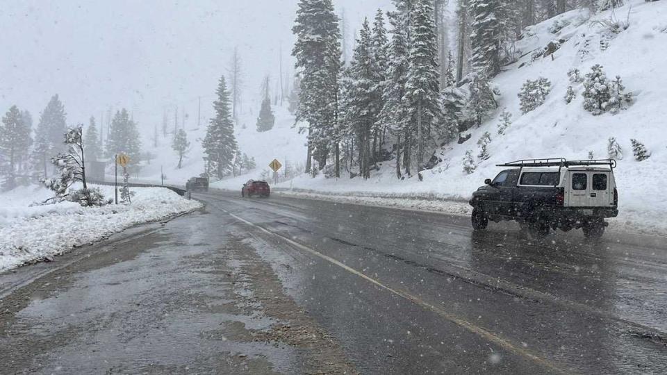
In the High Sierra, the storm’s significance could cause a “disruption to daily lives, including difficult to impossible travel.” Caltrans officials in Sacramento were urgently watching conditions on Interstate 80 and Highway 50 as spinouts began tying up traffic Friday night.
The incoming storms are expected to unload 3 to 4 feet of new snow in the Lake Tahoe area and a staggering 5 to 6 feet farther south at Ebbetts Pass and Sonora Pass, the National Weather Service forecasts.
“Forecasters advise to avoid mountain travel during this period if possible,” Caltrans District 3 officials said Saturday morning. “If motorists must travel, Caltrans advises to pack extra supplies including snacks, water, a blanket, and a flashlight.”
This weekend’s storms will provide a major boost to the Sierra Nevada snowpack, the source of one-third of California’s drinking water.
The snowpack was just 25% of normal on Jan. 1. But it has grown steadily due to several significant January storms. On Friday, it was 57% of normal.
“This is going to be a really big storm — certainly the biggest and most intense storm of the year so far, and we’ve seen some decent ones,” said Swain. “This will probably be the biggest snow event in the Sierra Nevada so far this year. It’s going to be a travel nightmare, but it’s good news from a snowpack perspective.”
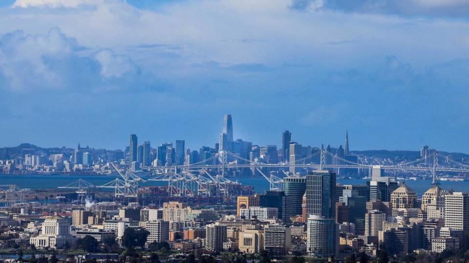
Bay Area will also have issues
In a replay of this week’s storm, most Bay Area residents will also see 2 to 3 inches of rain from late Saturday night until Monday morning, with 4 to 6 inches or more dumping on the Santa Cruz Mountains, North Bay hills and Big Sur.
“It’s going to be a big deal in the Bay Area,” said Jan Null, a meteorologist with Golden Gate Weather Services in Half Moon Bay. “But it’s going to be a really big deal in Southern California. We’re not going to get by unscathed. But they are going to get it worse.”
Larger Bay Area rivers that are prone to flooding during the winter, such as the Russian River in Guerneville and the San Lorenzo River near Felton, are forecast to rise steadily on Sunday and Monday but still remain several feet below flood stage. The Pajaro River in Watsonville, which flooded badly last winter when levees failed, has a 21% chance of reaching its flood stage of 24 feet by Monday, the National Weather Service said.
Flood watch, high winds for capital region
In the Sacramento Valley, rain amounts are expected to be between 2 and 3 inches, with the highest amounts anticipated in the foothills east. A flood watch will last through Tuesday morning and officials are keeping an eye on swollen waterways along with ponding and minor flooding in poor drainage areas.
Temperatures are expected to run in the mid- to upper 50s during the day and mid- to upper 40s overnight. Forecasts are showing rain amounts Sunday between three-quarters and one inch, with another quarter- to half-inch after sundown Sunday.
But meteorologists’ immediate concern for the Sacramento Valley were winds, similar to the strong gusts that knocked down trees, fences and power lines 13 months ago.
A high wind warning for 30- to 45-mph winds will remain in effect through Monday — gusts on the Valley floor could reach 55 mph, the National Weather Service said, and gusts “between 60 and 70 mph are possible” in the foothills of Placer, El Dorado and Nevada counties.
“Gusty winds will spread from south to north during the day on Sunday,” forecasters said in the warning advisory. “The strongest winds are expected to develop from mid to late Sunday morning and persist through Sunday evening.”
The Sacramento River, meanwhile, is likely to run just below 21 feet at the I Street Bridge downtown, well below monitoring stage, according to forecasts from NOAA’s California-Nevada River Forecast Center.
Most of the flows from the upper Sacramento and Feather rivers are expected to flow into many of the Valley’s flood channels, like the Yolo Bypass. Upstream diversions, such as Tisdale Weir and Colusa Weir were already at monitoring stage Saturday evening, according to the CNRFC.
But smaller streams, such as the Cosumnes River in southeastern Sacramento County could see high flows — gauges at Michigan Bar and McConnell, where flooding persisted during the New Year’s storms of 2023 — showed the waterway above the 7-foot monitoring stage Saturday afternoon.
Dry skies are forecast to return Tuesday and Wednesday, with a smaller system next Thursday and Friday, and more dry weather expected the following weekend for Super Bowl parties.
El Niño, climate change fueling conditions
This winter, El Niño conditions are present. When they occur, changes in wind patterns cause ocean waters near the equator off Peru to be warmer than normal, which can affect weather patterns across the globe.
Historical records going back to the 1950s show that in Northern California, El Niño years have about an equal chance of being wetter than normal as they do of being drier than normal. But in Southern California, El Niño years more often mean wet winters.
Right now, ocean temperatures across the Pacific from California to Hawaii are 3 to 5 degrees Fahrenheit warmer than average, Swain said. That is due to El Niño, and climate change.
When atmospheric river storms — which are bands of moisture hundreds of miles long, often coming from the tropics — come barreling into the West Coast, warmer ocean conditions allow more moisture to evaporate into them, delivering more rain.
“You could imagine a future where California is significantly warmer, with more intense heat waves in the summer and less snow in the mountains,” Swain said, “with relatively little change in average annual precipitation — but large increases in flood and drought risk, as well as wildfire risk.”
The Los Angeles Times, the Bay Area News Group and The Sacramento Bee contributed to this story.

