Rain and snow continue pounding California with more torrential weather on the way
- Oops!Something went wrong.Please try again later.
LOS ANGELES — Authorities issued an evacuation order for over 1,500 people to leave a Northern California agricultural community early Saturday after a levee along a nearby river was breached by flooding caused by recent inclement weather.
Rain and snow pounded huge swaths of California on Friday, forcing highway closures across the state and one major dam to open its spillway for the first time in nearly four years.
Around 9,000 people were under evacuation orders in the state, California Office of Emergency Services Director Nancy Ward said.
In Tulare County, evacuation orders were issued for the parts of the small community of Springville and city of Exeter, due to flooding and swollen waterways, the sheriff’s office said. Evacuation warnings were issued along the Tule River in Porterville, population 62,000.
President Joe Biden on Friday approved a state of emergency request from Gov. Gavin Newsom, triggering federal assistance to state, “tribal, and local response efforts” caused by ongoing “severe winter storms, flooding, landslides, and mudslides” the White House said.
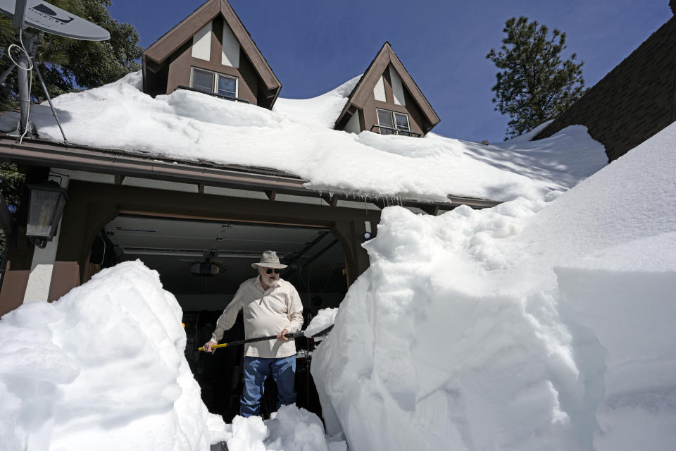
“We’ve been here about 20 years, and we really haven’t seen anything to this extent,” said Eric Diekmann of Soquel in Santa Cruz County, whose home is on the other side of a road that washed out.
Even after flood concerns taper Friday night, more bad weather is in store for the weekend and the coming days, National Weather Service meteorologist David Lawrence said.
The storm waned throughout Saturday, but another strong atmospheric event is expected on Monday that could bring more snow in the higher-elevated mountain regions and renewed flooding concerns.
"We will see additional rounds of both rain and heavy mountain snow redevelop across much of Northern and Central California as we go through the weekend," Lawrence told reporters at OES headquarters in the Sacramento suburb of Mather. "And we're also likely to see this weather pattern continuing as we go into at least the first half of next week."
Weeks of relentless snowfall has kept the state's transportation agency busy clearing roads of 45 million cubic yards of snow in the past month, enough to "fill more than 100 Rose Bowls," said California Department of Transportation Chief Deputy Director Mike Keever.
Recent storms prompted the state to release water from the main spillway at Lake Oroville midday Friday, with snowmelt likely to further swell lake levels in the coming months.
It’s just the second time water has been released from the rebuilt spillway, following the 2017 disaster that upended life around Gold Country and forced the evacuation of more than 180,000 people.

Some of the most famous and well-traveled roads in California were shut down at times on Friday because of flooding.
A portion of Scenic Highway 1 in Monterey County was closed due to rockfalls, water and debris.
Southbound U.S. Highway 101 near the state's garlic hub of Gilroy could not be used.
Interstate 580, a major highway through the East Bay of San Francisco, finally reopened by mid-day.
Main Street in Soquel, a community of around 9,900 in Santa Cruz County, washed away. In Kernville, northeast of Bakersfield, evacuation orders were issued due to high water in the Kern River.
Main Street in Soquel. Avoid the area. Residents north of Bates Creek cannot pass. Road crews are working on a solution. pic.twitter.com/wuKx7NmcjP
— Santa Cruz County (@sccounty) March 10, 2023
State authorities warned California residents that any amount of moving water can be dangerous.
As little as 6 inches of moving water can easily knock a person off their feet, while a foot of water has the force to sweep a car away, the San Luis Obispo Office of Emergency Services warned residents of the Central Coast Friday.
"Remember, do not walk, swim or drive through flood waters and avoid non-essential travel today," the agency said.
Transportation department officials urged state residents to check their weather before stepping outside.
The department cautioned drivers to be "prepared for delays and carry extra food, water, blankets and other essentials, and pack cellphone chargers."
The heaviest rain had moved out of Northern California by Friday afternoon, but not before dumping around 3 to 4 inches of rain in parts of the San Francisco Bay Area, according to the National Weather Service.
Flood watches were in place for San Luis Obispo and Santa Barbara counties until 4 a.m. Saturday, but the National Weather Service in Oxnard said Friday night that heavy rain had ended and waters were beginning to recede.
More than 10 inches of rain fell in Rocky Butte in San Luis Obispo County by 10 p.m., the weather service said, although other areas were lower. In the village of Cambria, where there had been evacuation orders for some residents that were later lifted, more than 5 inches of rain fell.
In Paso Robles, Chimney Rock Road washed away. A San Luis Obispo County spokesperson said they had issues with the road since January and had temporary fixes on it, but those failed Friday morning.
PASO ROBLES - Chimney Rock washout - we’re assessing this site and will follow up when we know more. This is a severe storm. Take warnings to stay home seriously. #storm2023 #stormdamage #slocounty @slocountyoes @CountyofSLO pic.twitter.com/bdFAnCnRhx
— County of SLO Public Works (@SLOCountyPWD) March 10, 2023
Fresno County first responders made rescues, including three women, two of whom were in their 80s and one who was 104 years old, who were trapped in their home after a culvert washed out, Sheriff John Zanoni said Friday.
A wintery weekend is expected in the Upper Midwest.
Blizzard conditions are anticipated in eastern Montana, North Dakota, and northern Minnesota through Sunday morning. An additional 6 to 12 inches of snow is projected with wind gusts over 45 mph.
A cold front could produce severe weather with the threat of hail, tornadoes, and damaging wind gusts in the Southeast and Southern plains.
A storm system on Friday dumped snow and rain across the Great Lakes, Northeast and Southeast with totals including 12 inches in Mequon, Wisconsin, 10 inches in Milwaukee, 9 inches in Woodstock, Illinois, and 4 inches around Detroit.
Rain and snow showers will continue to move from the eastern Great Lakes through the Mid-Atlantic region.
Western New York and northeast Pennsylvania could see 1 to 2 feet of snow.
This article was originally published on NBCNews.com

