These are the California rivers that face flooding from storm
For the record:
7:59 a.m. Jan. 10, 2023: An earlier version of this article said the Russian River is in Napa and Mendocino counties. It is in Sonoma and Mendocino counties.
Continued heavy rains have California concerned about rivers that face high flood risk.
At least nine rivers across the state could exceed the flood stage Monday, and 32 locations could exceed the flood monitor stage, according to the National Weather Service's California-Nevada River Forecast Center.
Officials with the joint state-federal Flood Operation Center are focused on the Cosumnes River in Sacramento County, which has already experienced deadly levee breaches, among other areas. Crews on Monday were placing "flood fight" materials on about 4,000 linear feet of levee to mitigate erosion due to overtopping, said Jeremy Arrich, manager of the Division of Flood Management with the California Department of Water Resources.
Significant rises on CA rivers the next 2 days with several locations reaching flood stage. Band of moderate to heavy precip moving south and east through the region today with scattered showers behind it. Another system will bring widespread precip Tues. #cawx #cawater #nvwx pic.twitter.com/TVaXBK2jDw
— NWS California-Nevada RFC (@NWSCNRFC) January 9, 2023
At least three people were found dead in or near their submerged cars after waters broke through levees last week.
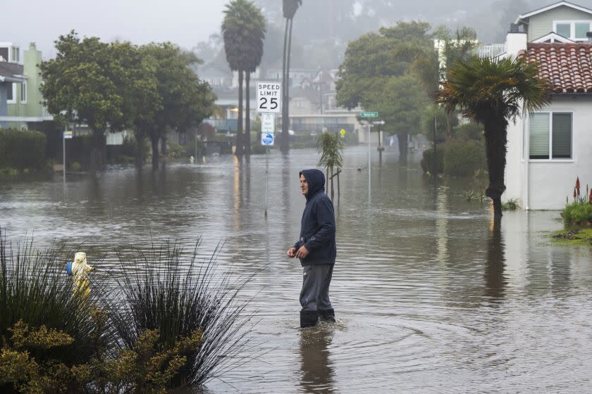
Major flooding was reported Monday along the San Lorenzo River in Santa Cruz County.
Officials are also monitoring Bear Creek in Merced County, the Russian River in Sonoma and Mendocino counties, the Carmel River in Monterey County and the Pajaro River in Santa Cruz and Monterey counties, Arrich said during a news briefing.
Across 13 counties, officials have delivered more than 180,000 sandbags and 3,000 feet of reinforcing muscle wall, as well as flood specialists who are providing technical support.
"As the storms persist, the Flood Operations Center will continue coordination with public safety entities to respond and prepare for these impacts we're seeing statewide, and this includes preparing for road closures [and] gathering additional flood fight supplies from some of our state warehouses," Arrich said.
While the fifth in the series of atmospheric rivers that have pounded the state since December might not be overwhelming on its own, “the collective nature of it becomes a volume management issue,” said Michael Anderson, state climatologist at the Department of Water Resources. “You start seeing compounding events occur.”
As the storm makes it way south into steeper coastal terrain, it is also creating landslides, debris flow and other hazards. Montecito was ordered to evacuate Monday afternoon as the storm brought heavy rains and damaging winds to the already soaked region.
DWR director Karla Nemeth said the storm system was “extraordinary” and “another climate signal” of California’s worsening swings between extreme conditions. The state, she noted, is experiencing a simultaneous drought emergency and flood emergency.
By far the most pressing matter Monday was the flooding, Nemeth said.
The state activated its Flood Operations Center last week.
Five of the six weirs in the DWR's Sacramento River Flood Control Project have passively opened after being triggered by overtopped systems. The sixth requires manual activation.
The Sacramento and San Joaquin River system “continues to be doing what we need it to be doing," Nemeth said, including flood releases from some smaller reservoirs.
“The rising levels in the San Joaquin system and Sacramento system are really due to how these atmospheric rivers are making landfall and how local rivers and creeks are feeding into the main stem of these river systems.”
The pounding rain washed out roads and sent already saturated soils sliding, further snarling traffic across the region.
Santa Cruz County — still reeling from significant damage along the coast from last week’s storm — was again experiencing some of the worst damage.
Early Monday, evacuations were underway and major flooding was reported in Felton Grove and Paradise Park after the San Lorenzo River rose over its banks and flowed into the surrounding community. Videos posted on social media showed muddy water covering cars and rising up to stop signs in Felton Grove as the San Lorenzo raged nearby, filled with logs and other debris.
The San Lorenzo crested at about 24 feet shortly before 8 a.m. and continued to recede as rain subsided slightly across the county, according to National Weather Service data.
Anderson said the evacuation in Montecito was largely due to the types of hazards that can come with steep terrain and wildfire burn scars.
"When you get heavy rain waves like this, it makes the land more prone to landslides and debris flow," he said. "And to make sure that we don’t repeat the incidents after the Thomas fire, they wanted to evacuate people from that area."
In January 2018, mud and debris loosened from the Thomas fire plowed through Montecito, killing 23 people and destroying more than 100 homes.
This story originally appeared in Los Angeles Times.

