Calvin on track to bring Hawaii drenching downpours


Soon after Calvin rapidly intensified into the eastern Pacific's first major hurricane of the 2023 season, it began to lose wind intensity Friday night and will continue to slowly unwind this week as it pushes westward toward Hawaii. However, AccuWeather meteorologists believe the system may still hold together enough to bring tropical storm conditions to portions of the state by Wednesday.
As of Monday morning, the National Weather Service has issued a Tropical Storm Watch for Hawaii as Calvin may bring heavy rainfall and dangerous surf to the Big Island on Tuesday and Wednesday. Calvin is rated a 1 on the AccuWeather RealImpact™ Scale for Hurricanes for Hawaii as a result of the impacts expected from tropical rainfall.
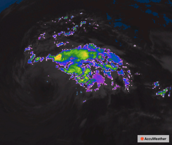
Calvin entered a zone that was highly favorable for intensification late this past week with water temperatures in the 80s F and light winds that surrounded the system. The hurricane peaked as a Category 3 hurricane with maximum sustained winds of 125 mph on Friday.
 |
Since then, a substantial drop in wind intensity has occurred. As of Monday afternoon, Calvin was a tropical storm with maximum sustained winds of 50 mph. The system was moving west at 18 mph and was 990 miles to the east of Honolulu, Hawaii.
Steering breezes will continue to push Calvin along to the west over the Pacific, through a large pool where water temperatures dip progressively lower through the 70s. Temperatures in the upper 70s to near 80 are about the minimum threshold for a tropical system to survive.
"As Calvin continues to move through progressively cooler waters this week, winds near the core of the system will steadily drop off," AccuWeather Meteorologist Alex DaSilva said. Because of this, Calvin is likely to continue losing wind intensity. Calvin may barely hold on as a tropical storm as it passes close by the Big Island of Hawaii on Wednesday. Should this loss in wind intensity occur more rapidly than expected, Calvin may disorganize into a tropical rainstorm prior to reaching the islands.
A tropical storm has maximum sustained winds of 39-74 mph, while a tropical depression has winds of 35-38 mph about a well-defined center.
 |
"Latest forecast trends support a slightly farther south track with Calvin, which would take the center of Calvin just south of the southern most point of the Big Island very late Tuesday night or early Wednesday," Senior Meteorologist Brett Anderson explained.
This southward shift will likely limit any wind impacts to the higher elevations and windward locations across the southern half of the Big Island from late Tuesday through Wednesday morning.
 |
"However, there will be some stronger winds just offshore and through the channel (funneling effect) between the big island and Maui with potential gusts in excess of 50 mph," Anderson said.
Waves will also start to increase in height starting Tuesday and may build to 12-18 feet just off the windward side of the Big island.
A general 1-2 inches of rain is in store for the islands, forecasters say, with 4-8 inches of rain most likely on the eastern slopes of the Big Island. An AccuWeather Local StormMax™ of 17 inches is most likely to occur within the 4- to 8-inch rainfall zone.
 |
Rainfall is typically sparse during the summer months in Honolulu and was close to average during June. The sporadic rainfall has dwindled since. Only 0.12 of an inch of rain has fallen thus far in July, compared to an average of 0.52 of an inch for the whole month.
"The main risks to lives and property will be from locally heavy rain that can lead to flash flooding and mudslides," DaSilva said. "However, rough seas, heavy surf and strong rip currents will be of concern for small craft, swimmers and boarders."
 |
There may still be locally gusty thunderstorms associated with the system that could trigger sporadic downed trees and power outages. This is most likely on parts of the Big Island.
The majority of tropical systems that were once hurricanes off the west coast of Central America weaken while moving into the cool waters just east of Hawaii. Occasionally, however, one can survive when waters are warmer or when such a more southerly track occurs in the warm water, followed by a northward turn toward the islands.
 |
Some of the most recent named storms to impact the Hawaiian Islands were Darby in 2022; Linda in 2021; and Hurricane Douglas in 2020. |
Despite the cool waters near Hawaii, there is still a chance that Calvin survives the westward track and hits the islands as a tropical storm. There is also the potential the system completely breaks down prior to reaching all of the islands.
Should Calvin take a track a few hundred miles farther to the south, impacts on the islands may be significantly less, even though the storm may stay stronger while tracking over warmer waters. Should Calvin veer more to the north, it will encounter cooler waters at a faster pace but may still have some success at bringing downpours and gusty thunderstorms to the islands.
Any non-flooding rainfall may be welcome in parts of the islands. The driest conditions were located in the western and central part of Maui, where moderate drought conditions were ongoing, according to the United States Drought Monitor.
Should little rain fall in some areas, the uptick in breezes generated by Calvin could raise the risk of wildfires, especially on Maui where the driest conditions already exist, AccuWeather Senior Meteorologist John Feerick said.
In 2018, Hurricane Lane caused winds to kick up over drought-stricken locations in Hawaii. The winds fanned the flames of fires that ignited.
Want next-level safety, ad-free? Unlock advanced, hyperlocal severe weather alerts when you subscribe to Premium+ on the AccuWeather app. AccuWeather Alerts™ are prompted by our expert meteorologists who monitor and analyze dangerous weather risks 24/7 to keep you and your family safer.
