Canada’s cold air brings Mexico some of Earth’s most violent winds
Frigid air from deep in the heart of Northern Canada sure gets around during the cold season.
Cold fronts during the fall and winter can send temperatures plummeting across Canada and the U.S., sometimes sweeping over the Gulf of Mexico and extending all the way into the tropics.
These intrusions of Canadian air usually arrive on gusty winds, but the setup can result in a unique and impressively fierce wind event in southern Mexico known as a Tehuantepecer.
DON’T MISS: Les Suêtes winds pose unique challenges for residents. Here are some of them
A wind that ranks among the world’s strongest
Vast storms that churn the atmosphere over entire continents can generate some pretty stiff wind gusts. But some of the most impressive winds you can see around the world occur as a result of quirks in local topography.
Canadians are familiar with Cape Breton’s Les Suêtes winds and Newfoundland’s Wreckhouse winds, while southern California routinely sees wildfires fanned by the infamous Santa Ana winds.
All three of those localized wind events occur when air rises up one side of mountainous terrain, picking up speed as it compresses and rushes down the other side.
But that’s not the only way that terrain can influence winds. We can also see outflow winds, which blow when cold air funnels down through mountain valleys. Outflow winds are common across British Columbia's Lower Mainland when Arctic air cascades through the Fraser Valley.

Frigid Canadian air doesn't stop generating powerful winds at the border. Some of the most potent cold fronts can drop temperatures by 30+ degrees over short distances, with a reach that extends all the way to the tropics.
Mexico stretches more than 3,000 km long from its desert border with California all the way down until it meets the lush tropical forests of Guatemala.
Rugged mountains cover the vast majority of Mexico, which made passage between the Pacific Ocean and the Gulf of Mexico a herculean task in the pre-industrial era.

A map of Mexico's Isthmus of Tehuantepecer. (Dennis Mersereau/The Weather Network)
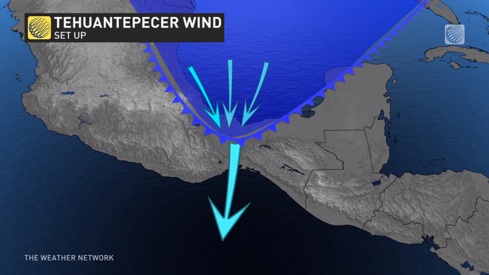
Only one tiny strip of land in all of Mexico allowed for an easy voyage from one side of the continent to the other.
This area, known as the Isthmus of Tehuantepec, measures about 200 km between the Pacific and the Gulf—but its most important feature is a small gap in the mountains that stretches about 20 km wide.
Cold air violently squeezes through a tiny mountain gap
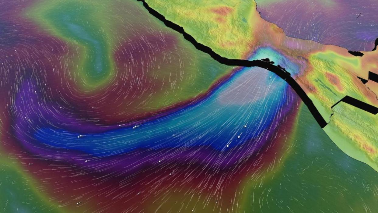
While this tiny passage made for relatively easy international travel, it also allows cooler air to pass from the Gulf into the Pacific. Cold, dense air struggles to climb over mountains, and this small gap in the terrain acts like a drain that funnels chilly air from one ocean basin to the other.
That exchange of air masses isn’t a gentle process.
Air spilling out of the Gulf of Mexico press through this mountain gap, forcing winds to accelerate as they race south toward the Pacific Ocean. It’s the same effect as putting your thumb over the end of a garden hose to make the water spray out faster.
These winds can thrash the coastal communities of Tehuantepec and Juchitán de Zaragoza with gusts exceeding 100 km/h.
One ship recorded a wind gust of 216 km/h during an intense Tehuantepecer in February 1974, an event that reportedly sandblasted the side of the vessel. The surge of cold air responsible for those winds was no joke—that air mass sent overnight lows close to -10°C in northern Florida.
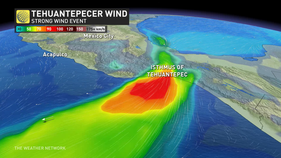
High winds roaring out of the mountain gap continue into the Pacific Ocean, threatening vessels in the region with ferocious winds and waves that can tower as high as 10 metres in the most extreme cases.
Tehuantepecer events can even cool the Pacific Ocean itself. The combination of high winds and rough seas can induce upwelling that chills sea surface temperatures by more than 10°C over the course of several days.
Cooler waters and the sudden increase in wind shear can also influence the strength and movement of any tropical cyclones that happen to meander through the region at the time.
Header image created using imagery courtesy of Unsplash.

