Severe storms continue rolling through Ontario, Quebec
6:19 p.m. EDT - While all tornado warnings have expired for now, a tornado watch remains in effect across much of eastern Ontario heading into Saturday evening as severe thunderstorms hit Ontario and Quebec just in time for Canada Day celebrations throughout the region.
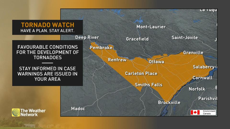
A tornado watch means that conditions are favourable for the development of tornadoes. The following areas in eastern Ontario are included in this tornado watch:
Petawawa - Pembroke - Cobden
Renfrew - Arnprior - Calabogie
Cornwall - Morrisburg
Brockville - Prescott
Merrickville-Wolford - Kemptville
Prescott and Russell
Smiths Falls - Perth - Eastern Lanark County
City of Ottawa
Additional severe thunderstorm and tornado warnings are likely through the afternoon hours. Prepare to act in a hurry if dangerous weather threatens your location.
Stay with The Weather Network through the afternoon as our team provides constant coverage of this severe weather event.
The original article with the full forecast for Ontario and Quebec continues below.
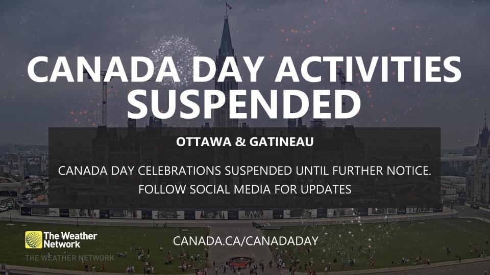
A widespread risk for severe thunderstorms will blanket Ontario and Quebec throughout our Canada Day. These storms pose a heightened risk given the number of outdoor events and gatherings planned through the evening hours.
Warm, unstable air parked over the region will allow widespread thunderstorms to grow with the day's heat.
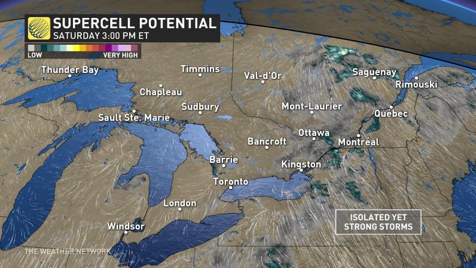
There is the potential for rotating thunderstorms, especially in eastern Ontario and southern Quebec. Tornado watches are already in effect for the National Capital Region, and we saw several tornado warnings in Quebec early Saturday afternoon.
Keep the radar handy on your phone if you’re under the threat of storms on Saturday, and make a plan to seek shelter in a hurry if hazardous weather approaches your location. If you can hear thunder, you’re close enough to be struck by lightning.
RELATED: This Canada Day, tour Canada from the comfort of your home
Saturday
Areas: Ontario and Quebec
Timing: Afternoon and evening
Weather:
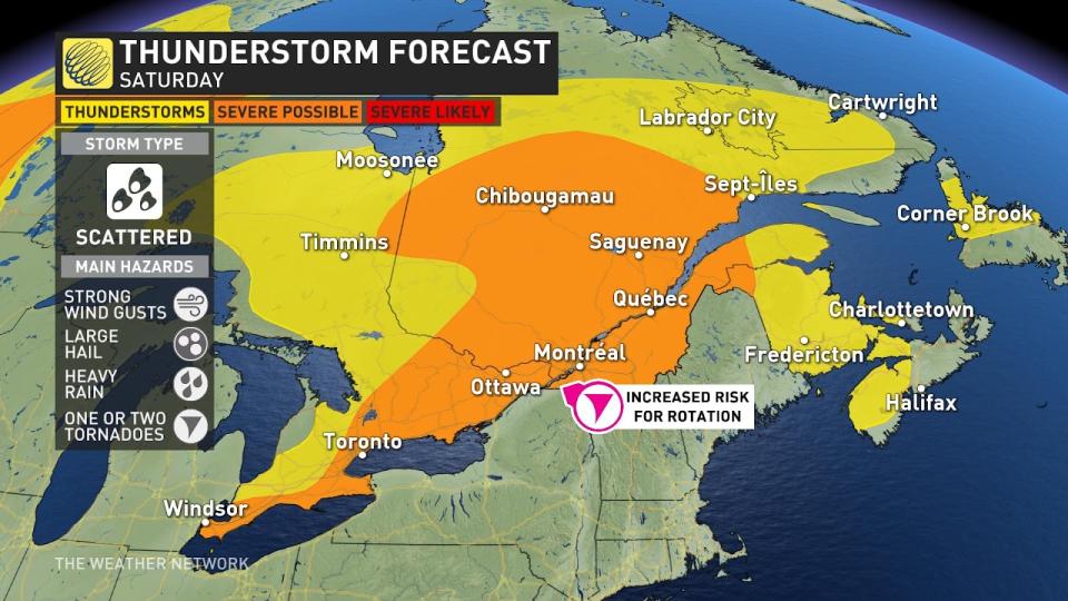
The risk for thunderstorms will continue Saturday throughout southern and eastern Ontario, with the threat expanding to include much of Quebec through the day.
Winds wrapping around a low-pressure system will pull a slug of warm, moist air surging into the region. This pool of unstable air will provide ample fuel for thunderstorms to thrive once they get going in the afternoon and evening hours.
The storms will be scattered in nature throughout the afternoon and into the evening as the system rolls through. There’s enough instability and wind shear to allow some of the storms to rotate, which will increase the threat for tornadoes and large hail across the area.
The strongest storms could produce large hail, strong wind gusts, and heavy rainfall. One or two tornadoes can’t be ruled out, especially in eastern Ontario and southern Quebec.
Thunderstorms will be more widespread than we saw on Friday, and they’ll be slow-moving, which could lead to localized flooding beneath the heftier storms.
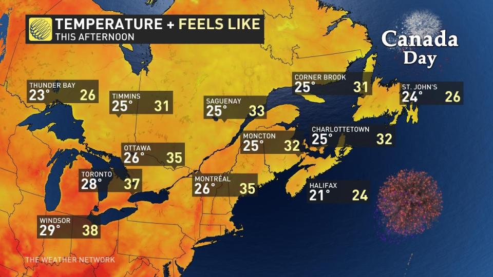
Heat and humidity alone will make the day uncomfortably sticky for anyone spending any length of time outdoors. Humidex values will climb into the low- to mid-30s for southern portions of Ontario and Quebec on Saturday afternoon, with a humidex in the upper 30s possible in far southwestern Ontario.
WATCH: Lightning safety tips you need to know this summer
A threat for potent thunderstorms during the afternoon and evening hours on Canada Day is especially tricky given the number of outdoor plans and activities scheduled throughout the region.
DON'T MISS: Tornadoes can happen anywhere—and cities aren't immune
Keep The Weather Network’s app handy on your phone to peek at the radar and keep up with watches and warnings as the day progresses.
Stay close to safe shelter in case storms threaten your location. And remember, the greatest danger in any thunderstorm is lightning. If you can hear thunder, you’re close enough to be struck by lightning.
Sunday
Areas: Ontario and Quebec
Timing: Afternoon and the evening
Weather: Some thunderstorms will continue overnight as the system continues to move towards the northeast.
A second low-pressure system will then track into the province early Sunday morning, bringing more widespread rain into the Greater Toronto Area (GTA) with some embedded thunderstorms and slightly cooler temperatures.
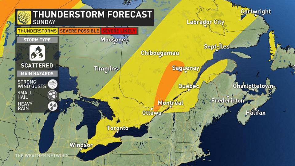
Areas in eastern Ontario into Quebec will also see the possibility of another round of severe thunderstorms in the evening.
Looking ahead, precipitation will continue as the threat of thunderstorms ramps up in Ontario as temperatures soar into the low 30s with humidex values nearing the 40s.
Stay with The Weather Network for the latest on the severe storm threat across the region.

