Canandaigua author's book shines light on historical error
CANANDAIGUA - What seems to have been a mistake made 234 years ago not only helped shape the Ontario County and western New York communities of today, but also served as thesis for a college paper and now, the basis of a book.
That alleged mistake on a survey done as part of the Phelps and Gorham Purchase created all sorts of problems, noted Canandaigua author John M. Robortella, whose “Steps West: The Field Notes of Col. Hugh Maxwell (1733–1799) — Pre-emption Line and Land Surveys in the Phelps and Gorham Purchase in New York State” is now available.
“Only 100 copies have been printed,” Robortella said in an email. “Not sure how much interest there will be, but I figured a few people might like to know the story.”
What follows is a question-and-answer session with the author. Answers are lightly edited.
Q: What is the Phelps and Gorham Purchase?

A: In 1788, Oliver Phelps, Nathanial Gorham and their investors — all from Massachusetts — purchased land in what is now western New York. Phelps and Gorham formed a company and bought the rights to the land from the Commonwealth of Massachusetts on credit. Their plan was to survey the acreage into towns of 36 square miles each, subdivide the towns into smaller lots, then sell the lots at a profit. They were to pay Massachusetts three installments of $1 million each in 1789, 1790 and 1791, with money from the sale of the land.
They also had to clear the Native American title before they could begin the sales. They were able to acquire title from to only about 2 million acres, less than half of what they originally thought.
Things didn’t go well for them.
Q: What went wrong?
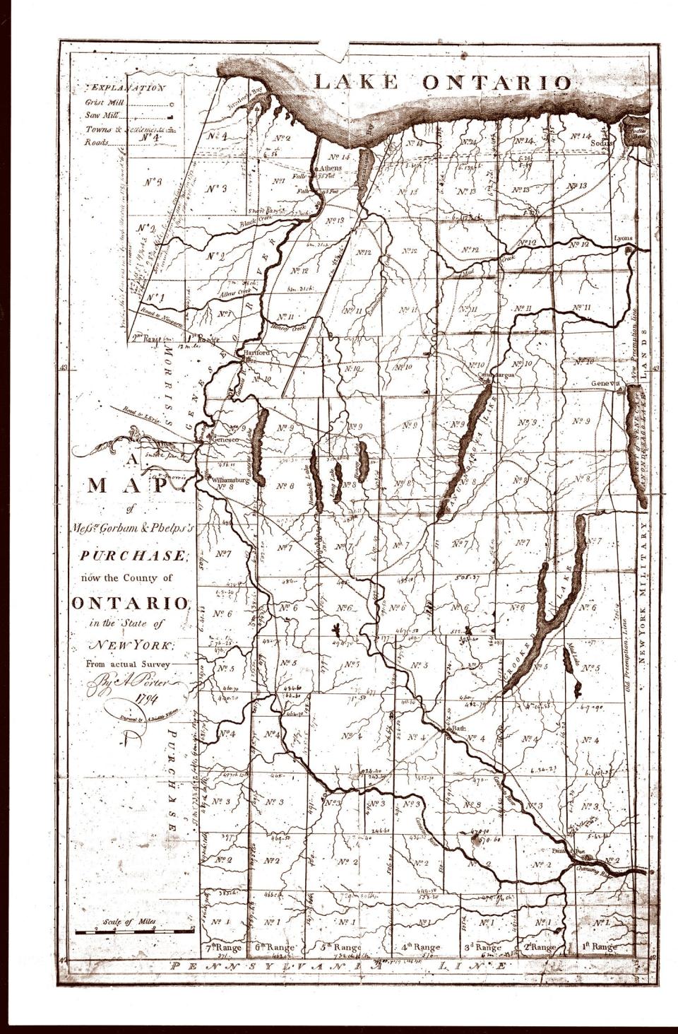
A: The survey of the eastern boundary of the Phelps and Gorham Purchase (known as the Pre-emption Line) was wrong, the Native American people would not sell their title to all the acreage that Phelps and Gorham originally sought, monetary values rose, and land sales were poor. Phelps and Gorham couldn't make their payments to Massachusetts. What was unsold reverted back to Massachusetts. Massachusetts then resold the land to Robert Morris of Philadelphia, "the financier of the American Revolution," as he was known.
The Pre-emption Line was to have run due north from the 82nd milestone on the Pennsylvania border along a geographic meridian to Lake Ontario. Oliver Phelps planned to make his land office headquarters at Kanadesaga, a Seneca settlement near present-day Geneva.
According to reckoning by eye -- even on the most rudimentary maps of the day -- a line drawn north from Pennsylvania would pass through Seneca Lake. The Native American settlement would be just west of the line and on the Phelps and Gorham Purchase.
Q: Who was Col. Hugh Maxwell?
A: To make the survey, Phelps hired Maxwell, who was an experienced surveyor of impeccable credentials and a Revolutionary War veteran known as “the Christian patriot.”
But in Col. Maxwell’s trial survey in June 1788 and his formal survey in July and August of that year, the Pre-emption Line veered to the west.
From the results of the trial survey, Mr. Phelps became aware that the line was not where he thought it would be. Without hesitation, he instructed his real estate agent William Walker to move headquarters to Canandaigua, about 15 miles west and a settlement that was certain to be on the Purchase.
Some historians wrote that the line was skewed to the west because it was the surveyor’s error. Others suggested it was fraud by members of a competing land company who infiltrated the survey team. Still others wrote that the colonel became ill and went home to Massachusetts, leaving his assistants to complete the survey.
The answer seems to be that the surveyor made a mistake that most middle school Earth science students would know the answer to.
Q: How did you learn of this and what made you think this was a subject for a book?
A: I just like telling stories, old ones or new ones, and I remember having heard that the original Phelps and Gorham boundary line was wrong.
When I was told that the surveyor’s notes from 1788 were in the Geneva Historical Society, I asked if I could read them to find out what happened. Curator John Marks brought out the original survey notes from the vault, and there wasn’t a transcript to read, so John made copies of the original notes and I did the transcript. That was about 20 years ago.
The first and last part of the book are reports that I had done when I was in college, even more years ago. So, when the pandemic hit and I was stuck at home, I thought about putting the pieces all together in a book form. I was glad that I kept my typesetting computer program.
Q: As a former newspaperman, can you describe the feeling you get at looking back at old stories as part of your research?
A: Since I retired from newspaper work, I don’t have any new stories to write. There’s so much history in western New York that I like to keep busy finding stories that a lot of us didn’t know. One of the best ones was watching the flames shoot up from the burning springs in Bristol.
I wonder how what happens today will be reported in the future with so much on electronic social media. There won’t be much of a paper trail to follow for the reporters who come after us.
About John Robortella
John Robortella of Canandaigua has worked on several local history books, including:
“The Farmington Railroad Tragedy of 1900,” with Reginald W. Neale and introduction by Preston E. Pierce;
“Writing Home: Civil War Letters from the Hinchey Family Archive," with Mickey Schlosser;
“Coldwater: An Eclectic History of the Hamlet,” in the Monroe County town of Gates, with Donald G. Ioannone; and
“The Gates Police Department: Two Centuries of Public Safety,” with retired Gates Police Officer William A. Gillette.
Robortella worked 32 years in printing and publishing at the University of Rochester, before retiring. He also worked at the Gates-Chili News for about 10 years and wrote the “Past Tense” local history column for Canandaigua Magazine and Rochester Magazine, which used to be published by the Rochester Democrat and Chronicle. He retired this year after seven years as the stenographer for the town of Canandaigua Planning Board.
About 'Steps West'
The 110-page soft-cover book includes a foreword and an essay on “Into the Phelps and Gorham Purchase,” followed by the transcription of the field notes, findings, and appendices with a biography of Col. Maxwell and transcriptions of a number of his letters.
Col. Maxwell kept a notebook of his surveys. It remained in his possession until his death when it was passed down to his children and grandchildren. Historians writing in the period from 1788 to 1882 perhaps never knew that the notebook existed. The first published excerpts appeared in the Ontario County Times in 1883 and 1884. In 1965, the notebook was presented to the Geneva Historical Society.
The book is published by Finger Lakes Historical Press.
Books are available at Cheshire Union Gift Shop, 4244 State Route 21, Canandaigua; Ontario County Historical Society Gift Shop, 55 N. Main St., Canandaigua; and Historic Geneva, 543 S. Main St., Geneva.
This article originally appeared on MPNnow: Canandaigua author John Robortella looks at Gorham-Phelps Purchase

