Cancellations, parking bans: What to know ahead of Sunday’s storm
It's time to get out those shovels. The SouthCoast is potentially on track to see its first snowfall of the season this weekend.
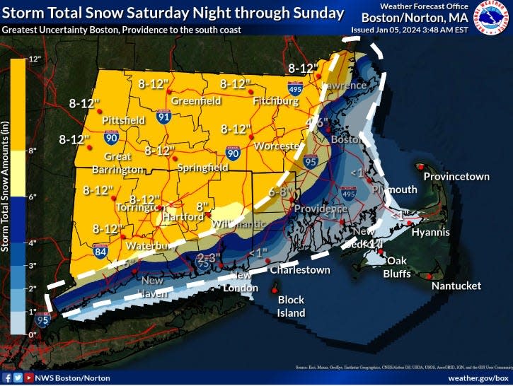
A winter storm watch is in effect for the region starting Saturday night, with up to 6-12 inches of snow possible for much of Massachusetts, Rhode Island and Connecticut, according to a post by the National Weather Service Boston on Friday morning.
"Latest trends suggest heavy snow may also fall in Boston and Providence and possibly southeast MA," the update continues.
The greatest forecast uncertainty encompasses southeastern Massachusetts, and coastal areas will see less snow. According to Friday morning projections, snow accumulation will likely only amount to one inch or less in the Fall River and New Bedford area, where the snow is also expected to mix with rain.
Weekend storm: National Weather Services forecasts 'plowable snow' for Mass., uncertain over inch counts
"The areas north and west of the I-95 corridor have the best shot at seeing plowable snow," said meteorologist Kyle Pederson of the National Weather Service. "As for the areas east of I-95 (like Cape Cod, Plymouth), we are still uncertain about those."
Parking bans explained: What to know when Fall River declares a parking ban due to a snowstorm
When will snow start and what to expect
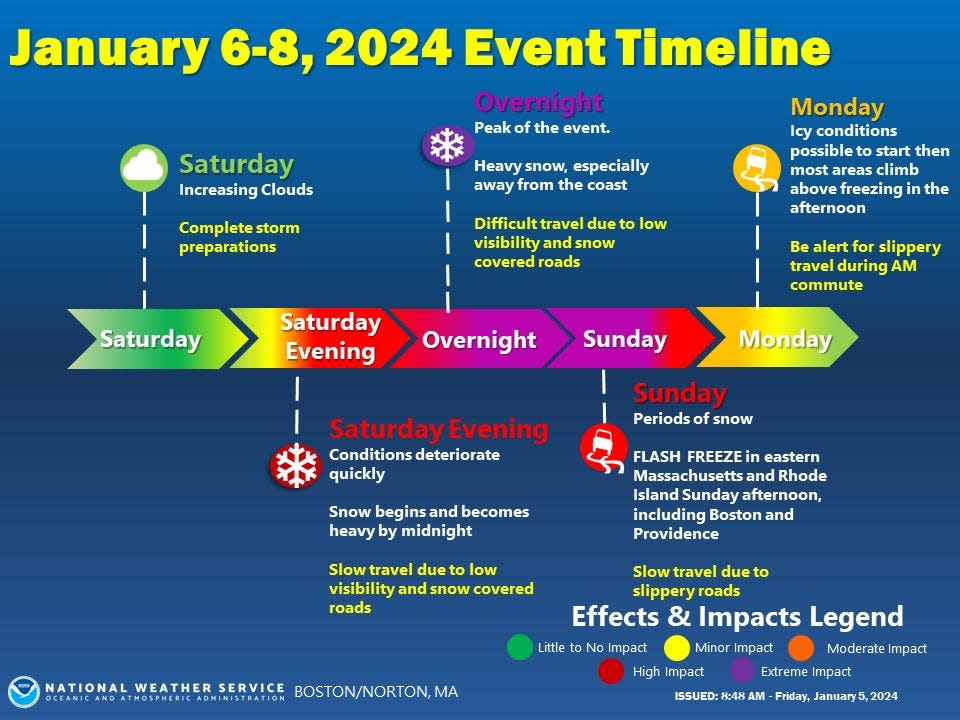
NWS forecasters expect the peak of the storm will hit the region Saturday night into Sunday, with snow becoming heavy by midnight. This will make for difficult travel due to low visibility and snow-covered roads.
A flash freeze in Rhode Island and eastern Massachusetts, including Providence and Boston, is predicted for Sunday afternoon.
Conditions are expected to improve Monday, but the NWS warns that motorists should be cautious for slippery travel in the morning commute. There will be possible icy conditions to start the day, before most areas climb above freezing by the afternoon.
Parking bans and closures in Greater Fall River
Ahead of the weekend storm, local communities have begun making preparations. Here's a list of parking bans, closures and cancellations that have been announced in the Fall River area.
FALL RIVER
A parking ban that was put in place at noon on Saturday has been lifted as of 9 a.m. Sunday, according to the office of Mayor Paul Coogan.
Forecast: Keep an eye on the weather forecast, and predicted snow totals
SOMERSET
The Town of Somerset announced that a parking ban will be in effect from 10 p.m. on Saturday, Jan. 6, through 10 p.m. on Sunday, Jan. 7.
SWANSEA
Swansea Police Department announced that a parking ban will be in effect starting at 10 p.m. Saturday, Jan. 6, through 10 p.m. Sunday, Jan. 7.
This list will be updated.
This article originally appeared on The Herald News: Snowstorm parking bans and cancellations in Fall River and New Bedford

