From caves to cemeteries, here are 15 'undiscovered treasures' in southern Indiana
Janet Eger and Teena Ligman have hiked hundreds of miles across southern Indiana. The two recently shared some family-friendly jaunts to "undiscovered treasures" in Lawrence and Orange counties. Eger is a district forester with the Indiana Department of Natural Resources and Ligman is a retired forester. Together, they visited 16 sites, many with historic significance, that offer scenic beauty, wildlife viewing and plenty of reasons to take photos.
The sites are on both public and private property. All the private locations allow public access, although some require permits for entering special areas such as caves.
Orange County: Wesley Chapel Gulf and a glimpse at Indiana's Lost River
Wesley Chapel Gulf is Eger's favorite. She said it's different every time she stops there. The area is 187 acres on the Hoosier National Forest in western Orange County.
It's named for the church, built in 1858, just to the north. The gulf was designated a National Natural Landmark in 1972 because of its geologic features. Here you can catch a glimpse at a portion of the Lost River, which for most of its miles flows underground. The gulf was probably formed when the rock structure collapsed, providing an opening into the underground stream below.
Ligman said the gulf's waters have color and depth and spots that whirl "like a toilet bowl sometimes." There is a short walk to the steep-sided depression, so visitors should exercise caution.
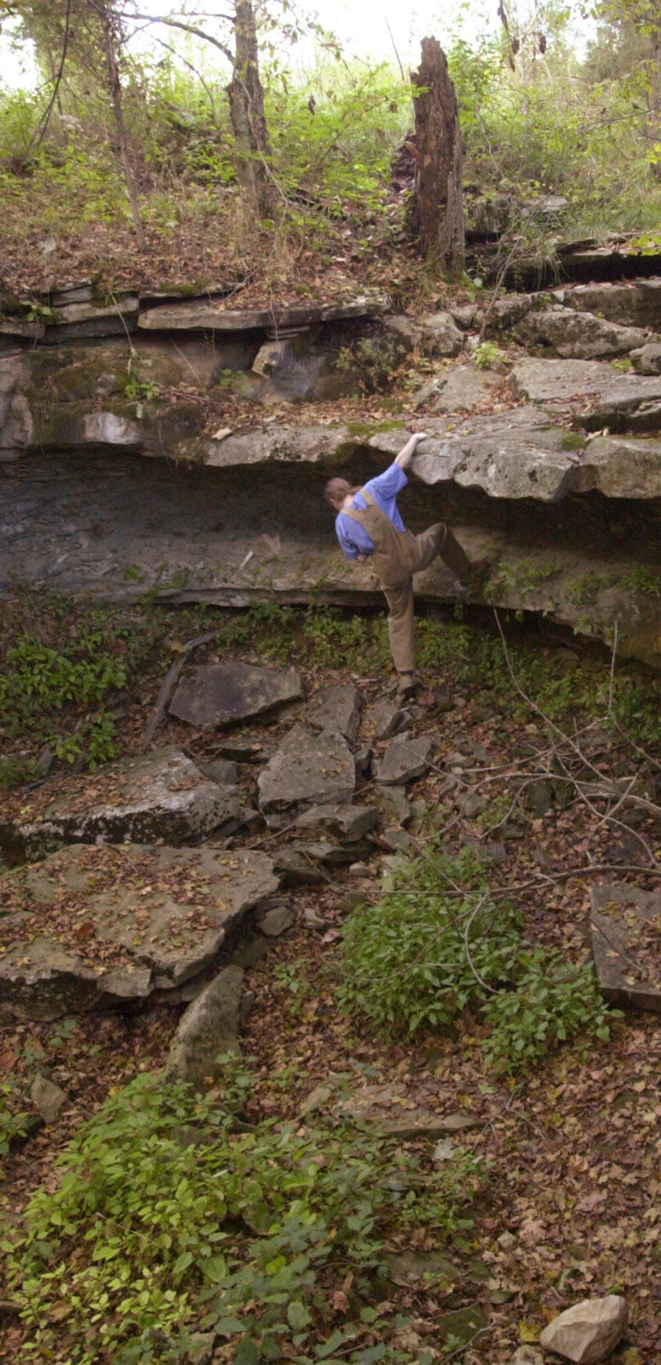
The gulf measures 1,075 feet in length and is about 350 feet wide. The walls range from 25 feet on the northwest side to about 95 feet on the southwest side. Be aware that if there is a heavy rain event, the water in the gulf can rise quickly. Location is 4742 350 West, Orleans.
Orange County: Indiana's Lost River bubbles up at Orangeville Rise
Visiting Orangeville Rise is another way to get a view into the Lost River as it surfaces from the caves and passages underground. The three-acre area also is in Orange County, within the town of Orangeville.
It was designated as a National Natural Landmark in 1972 and dedicated as a state nature preserve in 1975. The rise can be viewed from a pull-off area on the northeast side. After heavy rains, water bubbling up from the caves below can be dramatic.
Orange County: Elephants, giraffes and more at Wilstem Wildlife Park in Paoli
Wilstem Wildlife Park is a private animal park at 4229 U.S. 150 West near Paoli. Besides encounters with animals including elephants and giraffes, the park has trails where people can ride horses or walk and a drive-thru safari on the 1,100-acre property.
The park's buildings include a 10-bedroom lodge built with walnut logs cut on the property. The zipline offers a unique view of the land below.
Orange County: Lick Creek Cemetery in the Hoosier National Forest
Lick Creek Cemetery is part of the Lick Creek African American Settlement in the Hoosier National Forest. The hike to the cemetery is 4 miles, roundtrip, from the parking lot along Grease Gravy Road (250 East).
A kiosk nearby tells of the African American families who traveled to the area to establish their homes in 1811, five years before Orange County was established and Indiana became a state. The settlers were free citizens and, by 1860, the settlement was a racially integrated community.
Ground-penetrating radar has found 28 graves in the cemetery; not all have gravestones. The last person buried in the cemetery was Simon Locust in 1891. Locust served in the Civil War in Company E, 13th Infantry Regiment of the U.S. Colored Troops.
Forest management: Past and present converge at Lick Creek settlement, Buffalo Springs restoration project
Orange County: Learn about Indiana's beginnings at Pivot Point
Pivot Point, also known as Initial Point, is the location where the initial survey of land in what became Indiana was begun in 1805 by Ebenezer Buckingham, U.S. deputy surveyor.
A short trail leads to the kiosk and historical marker giving information about the importance of the survey. Three of the five people who were part of the initial survey died during the process — from a panther attack, malaria and drowning in a swamp.
Indiana was the first state to be completely laid out under the survey system used to set up the beginning of the legal descriptions of real estate still used in Indiana today. To get there, turn onto East Pivot Point Road from Ind. 37 south of Paoli.
Orange County: Old-growth forest preserved at Pioneer Mother Memorial
Pioneer Mother Memorial is an old-growth forest just south of Paoli, now part of the Hoosier National Forest, that was once owned by the Joseph Cox family beginning in 1816. Since that time, an 88-acre tract of the property has only had two walnut trees cut.
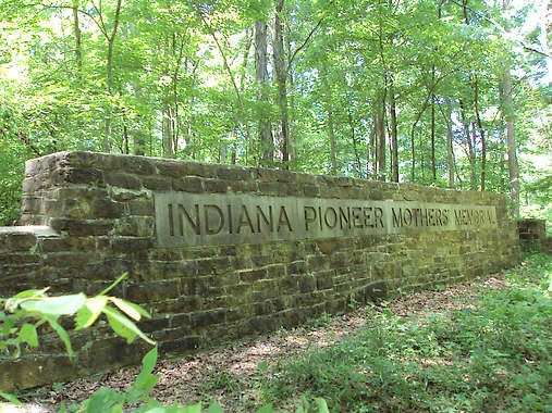
The land was put up for sale in 1940. Local officials worked with the U.S. Forest Service to purchase the land and keep it from an interested timber company.
A trail winds through the woods from U.S. 150 to Ind. 37, where there is a small parking area. A wall along the trail says "Indiana Pioneers Mother's Memorial," the name of the group that helped preserve the old-growth forest. In the bottomland area, Native American artifacts have been found.
Washington County: Cave exploration (with a permit) at Cave River Valley Natural Area

Just outside Lawrence County, in northwest Washington County, is Cave River Valley Natural Area, a satellite property of Spring Mill State Park.
The natural area is primitive, with no restrooms and no marked trails; a former road into the site is narrow and steep. There are about 30 caves on the property, including Endless and River caves, which are managed by the Indiana Karst Conservancy.
A hiker's path: Exploring the Cave River Valley Natural Area
Anyone who wants to enter the two caves must have a permit from IKC. No one is allowed to enter the other caves. The preserve has streams running out of the caves and an abundance of wildflowers in the spring. Located at 6031-6871 North Cave River Valley Road in Campbellsburg.
Lawrence County: Spring Mill State Park's gristmill and Pioneer Village
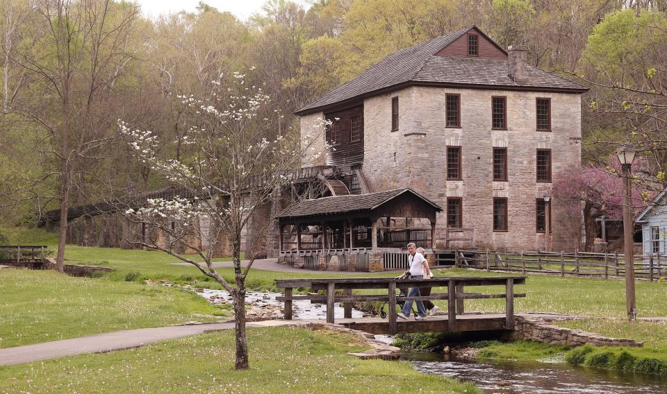
Spring Mill State Park near Mitchell has a restored Pioneer Village founded in 1814 that has a three-story limestone gristmill and other historic buildings.
Water from Mill Creek turns the water wheel that powers the gristmill, which is currently under renovation and not operating. There are plenty of hiking trails throughout the village and beyond, up the hill to the Lakeview Activity Center or along the Stagecoach Trail in the Mitchell Karst Plains Nature Preserve or to the Hamer Pioneer Cemetery. Note that the park's Spring Mill Inn is closed for renovations.
What did they find? Hundreds of artifacts unearthed in Spring Mill State Park
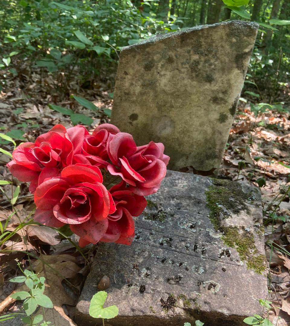
Lawrence County: Unique gravestones in Talbott Cemetery
Talbott Cemetery — one of several cemeteries on the list — has some amazing gravestones, including one for David Huston (1814-1884) that's carved to look like a tall remnant of a tree that has a hound lying on one side, a rifle propped up against it on another.
The cemetery also has one of the largest Eastern red cedar trees in the state (on the east side). Many of the gravestones are whetstone, which weathers well and makes the information legible for years. The cemetery is located off Bono Road on County Road 1000 S.
Lawrence County: Swallets and sinkholes at Buddha Karst Preserve
Buddha Karst Preserve is a 37-acre private property owned by Indiana Karst Conservancy. There once was a farm on the land but now it has an interpretive trail and informational kiosk that tells about the wet-weather swallets, sinkholes and two caves. Anyone who wants to enter a cave must have the proper permits from IKC first.
Lawrence County: Spring wildflowers and a waterfall at Jeremy Keith Oakley Preserve
Jeremy Keith Oakley Preserve is a 15-acre Sycamore Land Trust nature preserve featuring a diverse mix of trees, wildflowers and wildlife. There is a rugged 0.3-mile trail that lets people enjoy some of the fields, woods and a stream with a waterfall that's in the valley. It's a good place to visit to see spring wildflowers.
Please note the parking lot is only big enough for three vehicles; if it's full, please stop by some other time. Location is 5244 Leesville Road in Bedford.
Lawrence County: Pond hopping on Avoca Park and Recreation's 40 acres
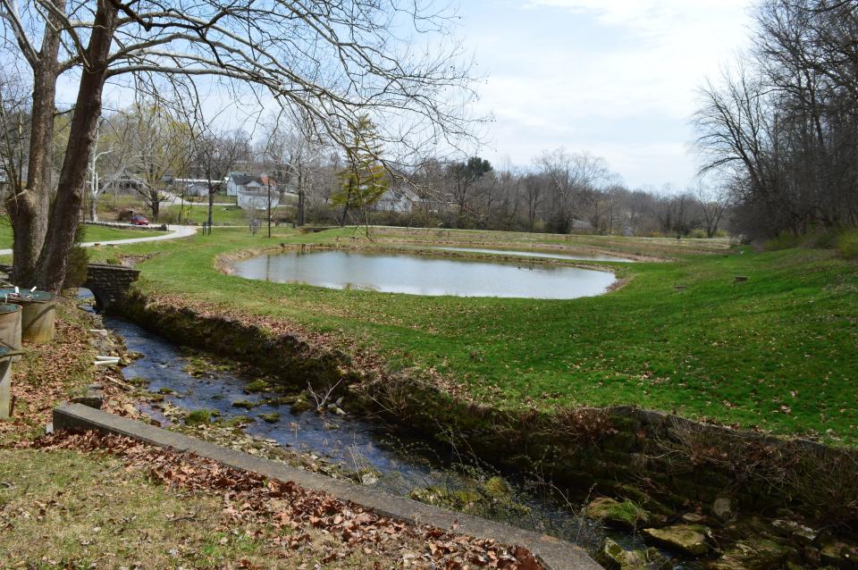
Avoca Park and Recreation, 3178 Avoca Eureka Road in Avoca, is now owned and operated by Marshall Township. It was once a state fish hatchery, which closed in 2013, and the ponds are still visible.
The park is open daily from dawn to dusk, with current hours posted on the gate. The Red Brick house, shelter house and overlook shelter can be rented.
There are trails throughout the 40-acre property, which is one of Eger's favorites. "Marshall Township has done such a great job of turning the old fish hatchery area into a wonderful family-friendly site," she said. A cemetery on top of the hill overlooks the ponds below. Check out the park's Facebook page for more.
Lawrence County: In this Burton Cemetery, a veteran requested burial standing up
Burton Cemetery (one of three with the same name in Indiana) has one grave for John Pleasant Burton, a private in the Revolutionary War (1758-1836), who was buried standing up.
According to an article in the Mitchell newspaper, Burton requested the unusual position. The story states Burton was a high-ranking Mason in North Carolina and made an agreement with fellow Mason George Zincher, that Burton would be buried vertically with Zincher buried horizontally at Burton's feet. When Burton was buried, Zincher performed the ceremony. Later he was buried at Burton's feet.
The newspaper article says, "To accomplish the vertical burial, holes were bored in the back of the coffin and Burton was roped upright. The coffin was lowered, foot-end first, into the perpendicular grave." This Burton Cemetery is on Burton Cemetery Road near Mitchell.
Lawrence County: Go fish, view wildlife at Williams Dam State Recreation Area
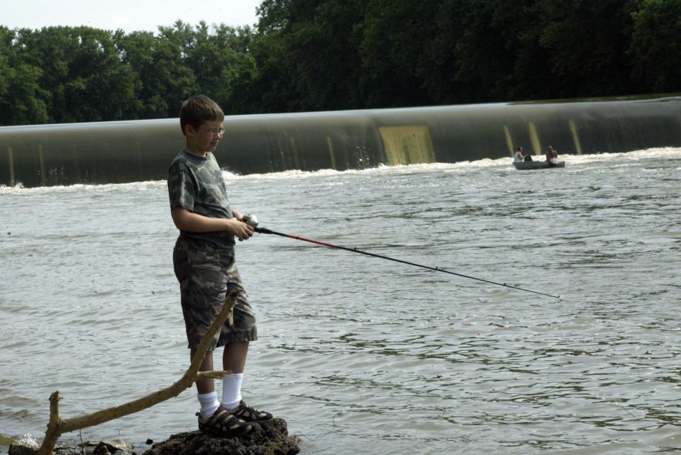
Williams Dam State Recreation Area along the East Fork of the White River just outside of Williams has a public fishing area and hiking trails where wildlife, including bald eagles, can often be seen. Of course, fishing is the primary activity at the dam, which at one time was used for hydroelectric power. The recreation area and dam are at 201 Williams Road in Williams.
Lawrence County: Underground boat tours at Bluesprings Caverns
Bluesprings Caverns, at 1459 Blue Springs Caverns Road, Bedford, is known to most people for its boat tours in the cave where blind cavefish and crayfish live.
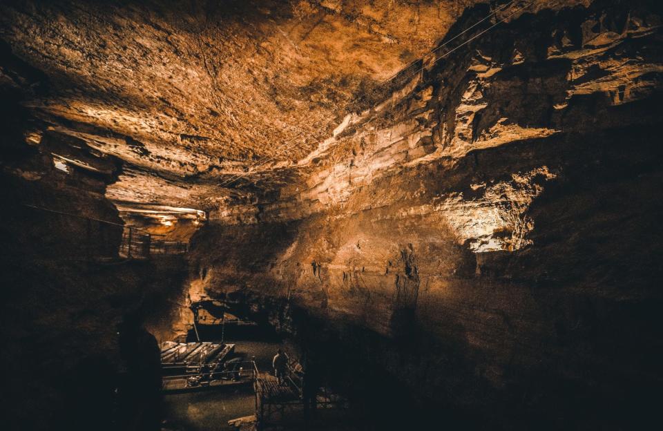
The caverns are currently closed and will reopen on March 16, 2024. Even so, people can stop near the entrance off the road and hike along the Karst Natural Area Trail to see one of Indiana's largest sinkholes.
Underground adventure: Red Bull athlete visits Bedford to ride electric surfboard through Bluespring Caverns
It's a half-mile walk and, according to Ligman, winter and spring are two of the best seasons to see the landscape of the area and also its early spring wildflowers. One of the flowers often seen there is the putty root orchid, one of Indiana's native orchids.
Contact Carol Kugler at ckugler@heraldt.com or 812-331-4359.
This article originally appeared on The Herald-Times: 15 'undiscovered treasures' to visit in southern Indiana in 2024

