Tornado watch: Iowa could see 'particularly dangerous situation' with violent tornadoes
Friday will mark day two of a hazardous weather outlook for Des Moines and central Iowa.
The threat of severe weather starts Friday afternoon in central Iowa. Eastern parts of the state have an even higher risk of tornadoes, damaging winds and hail.
A lot is on the table, so here's what you need to know.
LIVE UPDATES: Iowa tornado warnings, watches and updates as state prepares for severe weather
Tornado watch issued for parts of central, eastern Iowa
A tornado watch has been issued for parts of Illinois, Iowa, Missouri and Wisconsin until 8 PM CDT pic.twitter.com/A1jmfbIazi
— NWS Des Moines (@NWSDesMoines) March 31, 2023
The National Weather Service issued a tornado watch for parts of central and eastern Iowa, including Des Moines, Ames and Iowa City. The watch encompasses an area with a population of over 5 million people and will remain in place until 8 p.m. Friday evening.
A tornado watch means conditions are right for a tornado to form. Iowans should pay attention to conditions and be prepared to seek shelter.
The National Weather Service's warning states that "this is a particularly dangerous situation." Meteorologist Jeff Zogg said the National Weather Service does not typically issue that type of warning unless the situation "pose[s] a significant danger to the public."
"We're looking at the potential for severe weather this afternoon. Tornadoes, large hail, damaging winds. Any storms that do develop will move fairly rapidly. And there is the potential for violent long-track tornadoes too. So that's one of the reasons we put that kind of wording in there," he said.
Zogg recommended Iowans pay close attention to weather updates, such as through visiting https://www.weather.gov/dmx/, and to have a plan in place if severe weather hits their locations.
"Just be aware that any storms that do develop will intensify pretty rapidly and move fast as well," he said, adding Iowans should "know where you can go for safety if threatening weather does approach your location."
Risk of severe weather ranges from Level 1 to Level 4 across Iowa on Friday
Severe Weather Expected This Afternoon!
Storms are expected to develop around 2 or 3 pm just west of the Interstate 35 corridor and race northeast. All modes of severe weather are possible. Be prepared to seek shelter quickly as many of these storms will be severe! #iawx pic.twitter.com/ZVM9GAs8vm— NWS Des Moines (@NWSDesMoines) March 31, 2023
There is an "enhanced to moderate risk" for severe storms Friday afternoon in central Iowa, according to the National Weather Service forecast. Tornadoes and damaging winds are the main concern, with hail as another possibility.
The weather service says widespread storms could develop and move as fast as 50 mph across the state. Wind gusts could reach 70 mph. Hail could be as large as golf balls.
Safest place to shelter for a tornado? 🤔
👎 Underneath a Highway Overpass
👎 Mobile Home
👍 Most Interior Room of a Well Constructed House
👍 Basement@IowaHSEMD #IowaSWAW #iawx pic.twitter.com/w3C99taZQh— NWS Des Moines (@NWSDesMoines) March 29, 2023
In Des Moines, look for temperatures to reach a high of 76 degrees before storms arrive and cooler temperatures after. Showers and thunderstorms are most likely around 3-4 p.m.
Wind advisory issued for central and southern Iowa through Saturday morning
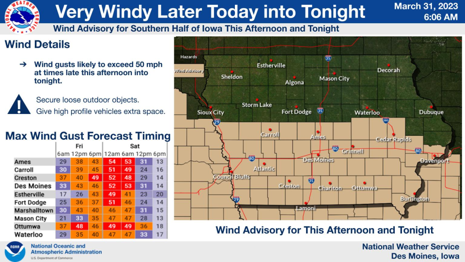
A wind advisory will go into effect at 1 p.m. Friday and continue through 7 a.m. for central and southern Iowa.
The National Weather Service expects west winds of 25-35 mph and gusts up to 55 mph during this time.
The gusts could blow around unsecured objects, bring down tree limbs and cause difficulty for drivers, especially with high-profile vehicles. The winds will also contribute to very high fire danger across the southern portion of the state.
Classes, events canceled at many Iowa schools
Dozens of school districts across the state are letting students out early as a precaution ahead of Friday afternoon's weather. Here are some of the biggest districts that have announced early dismissals thus far:
Iowa City schools are dismissing two hours early on Friday due to the threat of storms. All after-school programs and afternoon preschool are also canceled.
Cedar Rapids schools are dismissing one hour early.
Davenport Schools are dismissing two hours early on Friday. All extracurricular and after-school activities Friday evening will be canceled.
Waterloo Schools will dismiss one hour early on Friday and all after-school activities are canceled.
The University of Iowa athletics department also announced Thursday that it was canceling a women's Final Four watch party at Carver Hawkeye Arena.
What to expect in Ames
Look for a mostly cloudy day with a high near 74 degrees in Ames. Showers and thunderstorms are most likely around 4-5 p.m. Ames is in the Level 3: Moderate Risk category for severe weather. A mix of snow and rain is possible early Saturday before turning into snow after 4 a.m. Less than a half inch of accumulation is expected.
Iowa City, eastern Iowa has higher risk for severe weather Friday
SPC has upgraded much of the area to a Moderate (level 4 out of 5) risk for severe storms for Friday from 2 to 8 PM. Damaging winds to 70 MPH, tornadoes, and large hail will all be possible. The storms will be moving at 50+ MPH, so you will have little time to seek shelter! pic.twitter.com/cv50egSMYt
— NWS Quad Cities (@NWSQuadCities) March 30, 2023
Showers and thunderstorms are likely, mainly after 2 p.m. Some of the storms could be severe though, with damaging winds as high as 35 mph. The high is expected to be near 69 degrees. For Saturday morning, rain will fall before 5 a.m. before turning into snow and rain showers. Wind may still be as high as 45 mph with a low temperature of 31 degrees.
Tornadoes and large hail are possible, with those tornadoes being strong in nature, according to the forecast. Those strong winds could last through Saturday morning.
Snow could follow storms in central Iowa
The storm front will bring cooler temperatures to central Iowa.
There will be a chance of rain and snow from 1-4 a.m. Saturday, then a slight chance of snow after that as well as thunder.
4⃣ As the severe weather departs the state Friday evening, colder air will wrap into the state and northern Iowa has a chance of light snow accumulations Friday night.#iawx pic.twitter.com/DyjwVGn1eR
— NWS Des Moines (@NWSDesMoines) March 30, 2023
The low is expected to be around 32 with wind gusts as high as 50 mph. Less than half inch possible of new snow accumulation is possible.
Noelle Alviz-Gransee is a breaking news reporter at the Des Moines Register. Follow her on Twitter @NoelleHannika or email her at NAlvizGransee@registermedia.com.
This article originally appeared on Des Moines Register: Tornado watch issued in parts of Iowa: Violent tornadoes possible

