Impactful storm taking shape across the Central US to unleash snow, ice and perhaps Otis-fueled rainfall


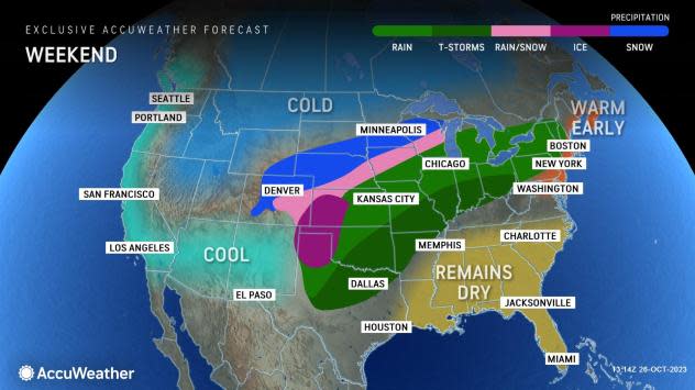
AccuWeather meteorologists say that two air masses will clash over the central U.S. this weekend, sparking the development of a multi-faceted storm across the region. Forecasters expect a zone of drenching rain to expand over the region, as a swath of snow and ice unfolds on the northwestern flank, bringing the first wintry precipitation of the season to some locations.
Tropical moisture will surge northward from the Gulf of Mexico, perhaps including some from former Hurricane Otis, and combine with an Arctic air mass plunging southward out of Canada into the northern U.S. This clash of contrasting air masses will lay the foundation for an impactful weekend storm across the center of the country.
The zone of wintry precipitation will follow an outbreak of cold air and rounds of heavy snow from the interior Northwest to the northern Rockies and northern Plains. Following a storm earlier in the week that unleashed cold air and snow across the northern Plains, the ingredients for yet another storm began to come together at the end of the week.
A plunge in the jet stream over the West has allowed cold air to blast across the Colorado Rockies at the start of the weekend. From the High Plains of northeastern Colorado and southeastern Wyoming to southern Minnesota and northern Wisconsin, a late-October chill will set in into Sunday.
"As the pattern evolves, many areas over the Plains and Midwest will experience the coldest air of the season so far this weekend to early next week," AccuWeather Senior Meteorologist Dave Dombek said.
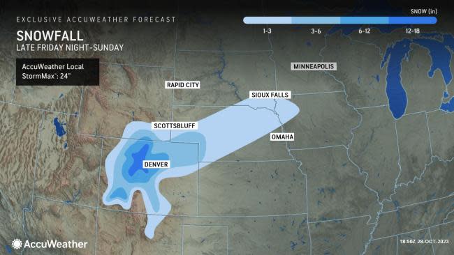
As the storm evolves, snowfall will occur across a nearly 1,000-mile-long stretch of the U.S. from the central Rockies to near the Great Lakes region through the weekend.
The setup will bring the Denver metro area its first widespread accumulating snow of the season, with accumulations around Denver amounting to 6-10 inches. As of early Sunday morning, locations across the Denver metro area have reported snowfall amounts of up to 8 inches.
 |
The storm is also likely to bring a general 6-12 inches of snow over the Colorado Front Range. Along the higher east-facing slopes of the Colorado Rockies, there is an AccuWeather Local StormMax™ of 24 inches. The Denver area averages about 5 inches of snow in October, and most of that snow tends to fall in one or two storms.
Airline delays are likely and flight cancellations are possible at Denver International Airport by Sunday.
Motorists should anticipate deteriorating travel conditions across the central Rockies to the central High Plains and perhaps part of the Upper Midwest through Sunday. Road conditions may vary from wet to slushy to snow-covered in this zone along portions of Interstates 25, 29, 70, 76 and 80.
 |
Farther to the south and east, where the air will not be cold enough for snow, rain will expand from central Texas and portions of the southern Plains through the middle Mississippi and Ohio valleys this weekend.
The rain will fall on some areas that were already drenched by rain several days this week. Around 1 inch to 4.50 inches of rain had been measured from Monday through Wednesday morning in the zone from central Texas to eastern Kansas. The Dallas metro area recorded a general 4-6 inches of rain with locally higher amounts during a 12-hour period Wednesday night.
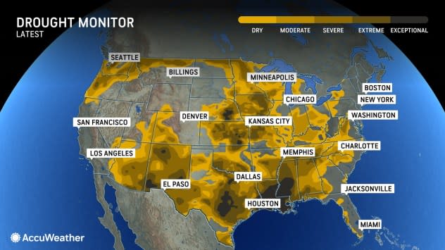
The first storm continued to bring beneficial moisture to some of the widespread drought areas into Thursday night.
As the weekend storm's rain falls over some of the same areas saturated this week, runoff may significantly boost water levels along area streams and rivers. Additionally, some tropical moisture associated with former Category 5 Hurricane Otis can be pulled into part of the weekend storm over the central U.S.
 |
Otis slammed ashore near Acapulco, Mexico, on Tuesday night with destructive winds, dangerous storm surge and flash flooding.
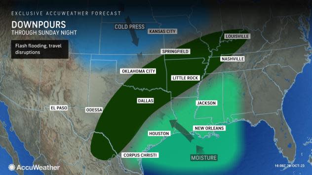
Even though Otis has dissipated over central Mexico, some moisture and energy can survive and reach the central U.S. this weekend in the form of a pocket of drenching rain and strong thunderstorms. AccuWeather forecasters say that the core of that heavy rain may travel from parts of southern and eastern Texas to portions of the Tennessee and lower Ohio valleys.
Any rain has the potential to induce flash and urban flooding, but the benefits of the rain in the central U.S. may far outweigh localized problems from flooding, rainy outdoor activities and slow travel. Since both the upcoming and ongoing rain has hit multiple parts of the Mississippi River watershed, some positive response in water levels is likely in the coming days and weeks.
 |
The water level rise on the navigational portion of the Mississippi River main stem will depend on the amount of rain that falls along the waterway itself in addition to the boost in water levels on major tributary rivers including the Arkansas, Missouri, Ohio and Mississippi River headwaters and timing thereof.
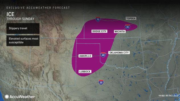
Between the zone of drenching rain and snow will be a shallow push of cold air that has the potential to produce a zone of sleet and freezing rain.
Early-season ice events are always tricky as much of the ground tends to remain too warm to allow much ice to accrue, explained AccuWeather Senior Meteorologist Dan Pydynowski.
 |
"But the air coming in is plenty cold enough to allow ice to form at least on some elevated surfaces over portions of the southern and central Plains through Sunday morning," Pydynowski said.
At this time, AccuWeather meteorologists have pinpointed an area from the Texas and Oklahoma panhandles to southeastern Colorado to western and central Kansas as most likely to face ice concerns. Most likely the icy areas will be limited to elevated surfaces, such as bridges and overpasses, but there can be some exceptions.
Some of the cities that are likely to experience freezing rain include Amarillo, Texas, Gage, Oklahoma, and Dodge City, Kansas.
It is possible that another zone of light freezing rain or drizzle will set up farther south in parts of western and central Texas Sunday night to early Monday. However, any ice in this area is likely to be spotty in nature.
"Temperatures will plunge into the 20s in the wake of the storm from Amarillo to Kansas City and Chicago by early next week," Dombek said, adding, "At that level, the lowest readings of the season so far will be undercut by 10-20 degrees."
Want next-level safety, ad-free? Unlock advanced, hyperlocal severe weather alerts when you subscribe to Premium+ on the AccuWeather app. AccuWeather Alerts™ are prompted by our expert meteorologists who monitor and analyze dangerous weather risks 24/7 to keep you and your family safer.
