Chance of freezing rain in parts of Beaufort County Friday night. Here’s the forecast
Editor’s note: This story has been updated. To find the most current weather information for Friday and Saturday, Jan. 21-22, please click here.
___
A second round of winter weather in less than a week could turn parts of Beaufort County icy Friday and Saturday.
A bulletin from the National Weather Service in Charleston said a cold front would push through the area Thursday. With the weather pattern, widespread freezing rain is possible early Friday evening through Saturday morning across much of southeast South Carolina and Georgia.
The closer a person is to the beach, the less likely they’ll see ice because of the warming influence of the Atlantic Ocean, said lead meteorologist Steven Taylor.
“Right now there’s uncertainty in how cold the atmosphere will be” in the Hilton Head area, he said. The forecast shows temperatures right at the freezing mark for the island.
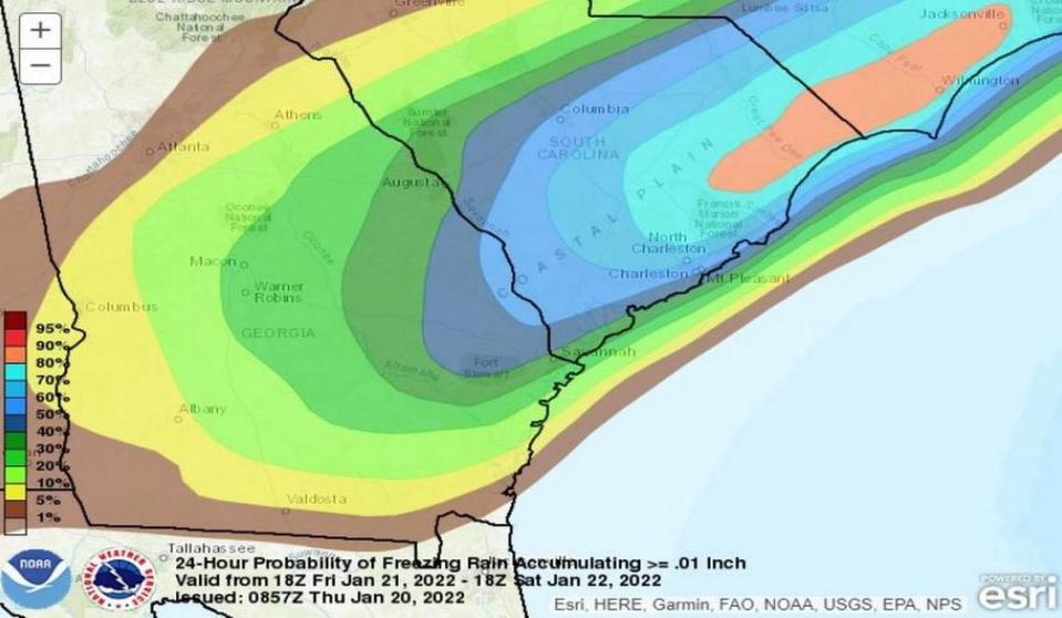
That means the greatest risk for freezing rain would be inland around Beaufort north to Yemassee and Walterboro.
“Closer to U.S. 17 and I-95,” Taylor explained.
A news release from the South Carolina State Climate Office said ice on elevated roads is possible Friday night, along with ice on trees and power lines that could cause power outages.
A sunny Saturday should warm the temperature up above freezing during the day, but any water left on roads Saturday night could become black ice as temperatures dip below freezing again.
And more winter weather could be coming behind this round.
“The pattern is favorable for more rounds of precipitation into the next few weeks,” Taylor said.
As the risk for a winter storm impacting Southeast South Carolina and Southeast Georgia increases, now is a time to remind everyone about some dangers associated with freezing rain. After all, freezing rain is the worst!#chswx #savwx #scwx #gawx pic.twitter.com/CTN3MO4Dc0
— NWS Charleston, SC (@NWSCharlestonSC) January 19, 2022
Beaufort County forecast
Friday
Rain. High near 44. North wind 11 to 13 mph. Chance of precipitation is 80%. New precipitation amounts between a quarter and half of an inch possible.
Friday night
Rain likely before 9 p.m., then freezing rain likely. Cloudy, with a low around 30. North wind around 11 mph. Chance of precipitation is 70%. Little or no ice accumulation expected.
Saturday
Partly sunny with a high near 42.
Saturday night
Partly cloudy with a low around 29.
Sunday
Sunny with a high near 49.
Sunday night
Mostly clear with a low around 32.

