Tropical depression forms in northeastern Gulf of Mexico, could become Arlene
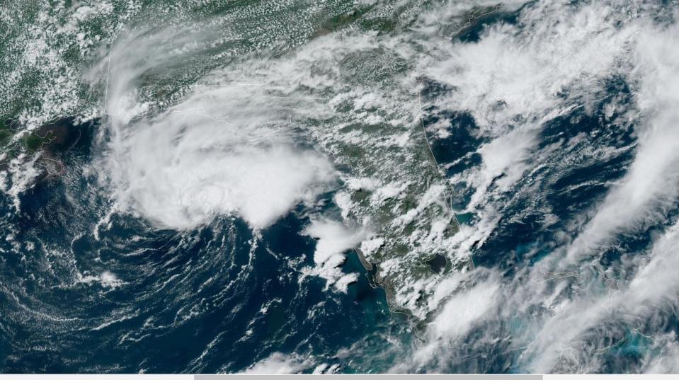
Mother Nature was unusually punctual on the first day of the 2023 hurricane season, conjuring a tropical depression in the northeastern Gulf of Mexico that is expected to goose afternoon thunderstorms in South Florida.
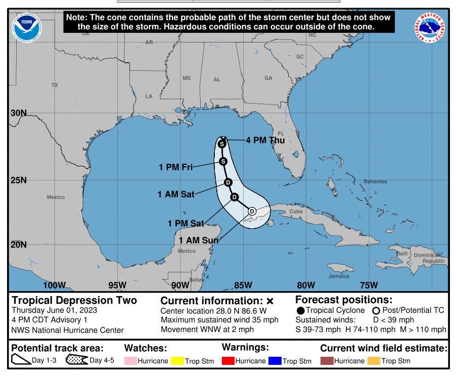
The depression, which could strengthen to Tropical Storm Arlene overnight, is forecast to begin moving south on Friday and remain offshore of Florida before being torn apart by wind shear.
As of 5 p.m. Thursday, the system was about 305 miles west-northwest of Fort Myers with maximum sustained winds of 35 mph. It was moving west-northwest at a lazy 2 mph.
The National Hurricane Center had increased the chances of formation to 70% at its 2 p.m. Thursday update after getting new data from buoy and ship observations. It designated it Tropical Depression Two later in the afternoon following a an investigation of the meandering system by a Hurricane Hunter aircraft.
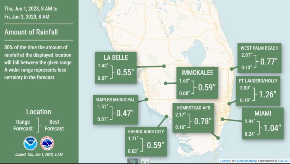
Regardless of whether it gains tropical storm-force strength, it is expected to bring heavy rainfall to South Florida through Saturday with up to 6 inches falling in isolated spots of Palm Beach, Broward and Miami-Dade counties.
A tropical storm is defined as a having wind speeds of 39 to 73 mph. The second name on the 2023 hurricane list is Bret.
Sammy Hadi, a meteorologist with the National Weather Service in Miami, said the system is sucking up moisture from the Caribbean to juice South Florida's typical afternoon thunderstorms.
NOAA 2023 hurricane season forecast: We really need El Niño to form this year
2023 hurricane season: Fear rain as much as storm surge as climate change increases threat
More: What’s an invest and why do they keep saying tropical cyclone?
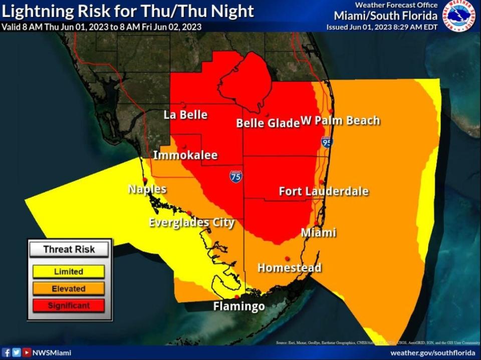
Generally, 2 to 4 inches of rain are possible through Friday evening with 5 to 6 inches possible in a few spots. Lightning, gusty winds and funnel clouds or tornadoes are also possible with the storms, which are also getting some extra kick from the sub tropical jet stream rushing overhead.
"This isn't a conventional tropical system that is very organized," Hadi said. "It will mainly be afternoon thunderstorms with rounds of showers resulting in heavy rainfall that could lead to localized flooding."
Downpours expected but far less than April's 'floodageddon' in Fort Lauderdale
The atmospheric setup, however, shouldn't carry the same deluge of rain that caused the severe flooding in April that shut down the Fort Lauderdale-Hollywood International Airport, stranded drivers, caused widespread fuel shortages and swamped some homes, Hadi said.
"In this case, the system isn't over us," he said. "It is adding more moisture so the rainfall rates will be higher."
More: Your guide to the 2023 hurricane season in Florida
This is the second tropical depression of 2023 following the recent determination that a subtropical storm formed off the northeastern coast of the US in mid January. The storm was not named.
Tropical Depression Two will battle dry air "lurking to its west" but it is forecast to reach wind speeds of 40 mph by Friday night, briefly designating it a tropical storm.
"It's the kind of what we expect in an early June mess of a system that may or may not get a name but probably just means rain for us," said National Weather Service meteorologist Nick Carr, who is based in the Miami forecast office. "It could get the name Arlene but the conditions just aren't favorable for much strengthening."
A flood watch is in effect through Saturday for Palm Beach, Broward and Miami-Dade counties. Because of the messy nature of the disturbance, Hadi said it's hard to forecast which areas could see the most rain.
Showers are expected to linger into at least Saturday.
Most seasonal hurricane forecasts are predicting a near normal hurricane season, including the National Oceanic and Atmospheric Administration and Colorado State University.
Kimberly Miller is a veteran journalist for The Palm Beach Post, part of the USA Today Network of Florida. She covers real estate and how growth affects South Florida's environment. Subscribe to The Dirt for a weekly real estate roundup. If you have news tips, please send them to kmiller@pbpost.com. Help support our local journalism, subscribe today.
This article originally appeared on Palm Beach Post: Palm Beach County is under a flood watch through at least Friday

