A change in the weather pattern could mean a chance of rain for L.A. next week
Although forecasters aren't confident in the long-range forecast, and the computer models don't agree, there is a chance for some rain in Southern California late next week.
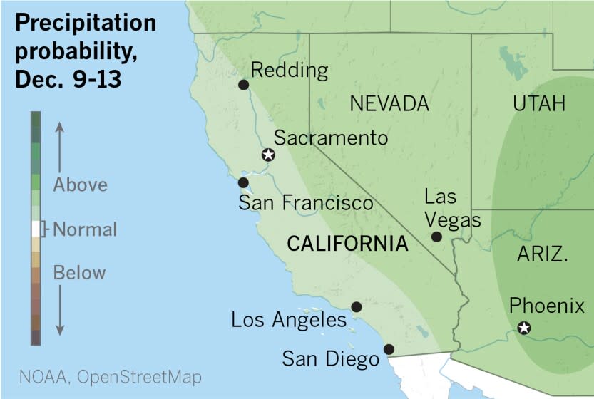
The six- to 10-day outlook from the National Oceanic and Atmospheric Administration favors above-normal precipitation across California, and the temperature outlook for the same period favors below-normal readings.
The reason for this glimmer of hope is a change in the weather pattern that has prevailed throughout the fall.
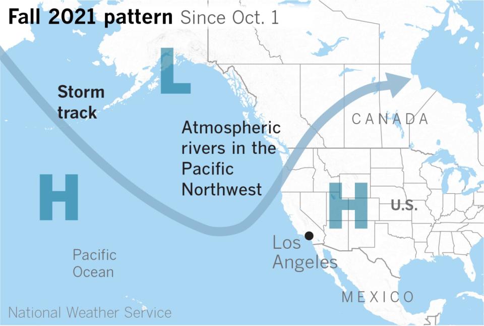
Since Oct. 1, a stubborn upper-level trough of low pressure in the Gulf of Alaska and the jet stream, also called the storm track, have been funneling numerous atmospheric rivers into the Pacific Northwest, said Alex Tardy, a meteorologist with the National Weather Service in San Diego.
"Wave after wave," he said, "like leaving the garden hose on overnight, but in this case, for two months — but not every day, of course." The hose has been persistently aimed at Seattle.
To the east of that trough, in the Great Basin, high pressure has been blocking the storm track and maintaining unusually warm, dry conditions in California. Los Angeles and San Diego just logged their driest Novembers in decades, and the state is under a drought emergency. Ski resorts in the Sierra Nevada around Lake Tahoe have delayed opening because of warm temperatures and lack of snow.
When the jet stream does dive into the western U.S., as low-pressure troughs move from west to east, it generally has been inland, in a configuration that favors dry Santa Ana winds. But late next week, the jet stream is expected to plunge much farther south and cut across Southern California, bringing a much better chance of precipitation for the region.
The key to how wet the storm will be is where it drops south. If it is another "inside slider," the name for systems that come down the West Coast over land and thus have no consistent source of moisture, it will be dry. If it comes down over the Pacific, or straddling the coast, it would have an abundant source of moisture and could provide beneficial rain.

High pressure with downsloping north to northeast offshore winds will bring several degrees of warming to Southern California on Sunday and Monday. Then a weak system late Monday will take an inside slider track, so no rain is expected to result. Drizzle is possible Tuesday morning if eddy circulation develops off the coast, then northerly winds will turn more northeasterly and offshore again later in the day. By Wednesday and Thursday, onshore flow returns once again.
After that, the models start to disagree. One model favors a track that's farther to the west, with colder, wetter results. Other models envision the storm taking a track that's too far inland to produce significant precipitation. But forecasters say a 20% to 40% chance of precipitation seems reasonable.
The location of the blocking high-pressure system plays a part in where the storm track moves down the coast. Sometimes it is said that the high retrogrades, or backs off to the west, allowing the storm track to come down the coast. But Tardy said it's a matter of meteorological debate whether the high moves the storm or whether the upper-level storm moves the high. Regardless, he said, it's not known exactly why the blocking ridge of upper-level high pressure over the North Pacific hasn't gone away — except temporarily — for the last two years.
The current weather pattern that has largely persisted through the fall favors offshore, generally northeasterly Santa Ana-like flow in Southern California — that is, winds that move from inland deserts toward the ocean. Santa Ana wind events peak in December and January, although, as Tardy points out, October is the month when the most acreage is burned in Southern California fires.
According to the latest U.S. Drought Monitor report, California remains in the grip of extreme to exceptionally dry conditions, so although some forecast models provide small glimmers of hope, none would produce enough precipitation to dent the state's drought.
This story originally appeared in Los Angeles Times.

