Changes to 2024 Hurricane Forecasts, Plus, How Upcoming Season Might Play Out

While the start of hurricane season is not until June, and the peak of the season is still six months away, the National Hurricane Center and various other agencies are already looking ahead.
The NHC announced Tuesday that meteorologists with the agency will start using an experimental cone on or around Aug. 15 that will inland tropical storm and hurricane watches and warnings.

The changes are meant to communicate wind-related risks to inland residents and businesses in order to prepare for storms more efficiently, according to the announcement.
Currently, the NHC outlines coastal warnings with a shaded line. But, local National Weather Service offices include all tropical-related inland advisories on their respective web pages and products.
Forecast cones will also be shaded in, instead of hatched, during the day four and day five periods. Currently, the cone is shaded in white for only the first three days.
The NHC will continue to review their products and ask for feedback regarding any future changes.
The changes come ahead of what may be another active hurricane season. More on that is below.
Hurricane Season 2024: An Early Look
El Nino and Southern Oscillation (ENSO): What Is It?
An El Nino is the warm phase of the El Nino and Southern Oscillation (ENSO). The process plays out in the Equatorial (Eastern) Pacific Ocean off the coast of South America. But, temperature anomalies can also be observed in the Central and Western Pacific Ocean.
Normally, trade winds blow from east to west (easterlies) across the Equatorial Pacific, from South America to the Western Pacific. If these winds relax, there is reduced upwelling of colder, deeper water off of South America. This results in warmer water at the surface and the warm-phase El Nino.
Conversely, if the trade winds are stronger, there is more upwelling of colder water, leading to La Nina.
If the sea surface temperatures are at least 0.5° warmer than average for three months, then there is an El Nino. If they are least 0.5 °average than normal for three months, then there is a La Nina. If the sea surface temperatures are within 0.5 °of the long term average, then this is what is called ENSO neutral.

ENSO phases can further be broken down into their strength. Sea surface temperatures that are between 0.5 ° and 0.9 ° warmer (cooler) than average characterize a weak El Nino (La Nina). Waters between 1.0 ° and 1.4 ° warmer (cooler) than average characterize a moderate El Nino (La Nina).
If sea surface temperatures are between 1.5 ° and 1.9 ° warmer (cooler) than average characterize a strong event. If the anomalies are 2 ° or greater, then the event is defined as very strong.
The Oceanic Nino Index (ONI) is the measurement used to classify these Nino events. It takes into account the waters off of South America. Another metric, the Southern Oscillation Index, measures the sea level pressure different between Tahiti and Darwin, Australia.
ENSO: How Does It Affect Seasonal Activity and Tracks?
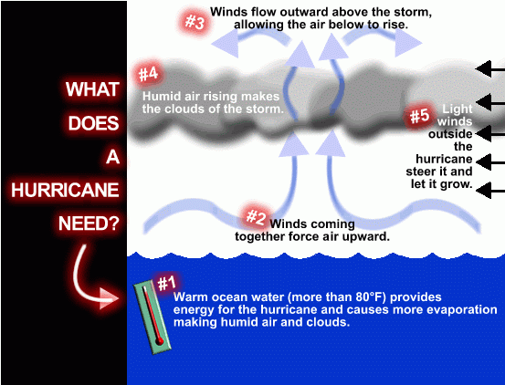
What happens in the ocean off of South America couples itself to the atmosphere, leading to global climatic effects.
In an El Nino, there is greater wind shear. Typically, hurricanes move east to west in the Atlantic Ocean. But, El Nino results in higher winds blowing west to east at higher levels. This rips apart developing storms.
Furthermore, warmer, unstable air will rise over the Pacific Ocean. But in the Atlantic, cooler, drier more unstable air sinks. This lack of instability also puts a lid on activity, and most seasons finish below average.
For reference, the 30-year average for seasonal activity is 14 named storms, seven hurricanes, and three major hurricanes (Category 3 or higher).
In La Nina events, this is flipped. There is much less wind shear but higher instability over the Atlantic Basin, leading to most seasons finishing above average. In ENSO-neutral years, there are no significant departures from average.


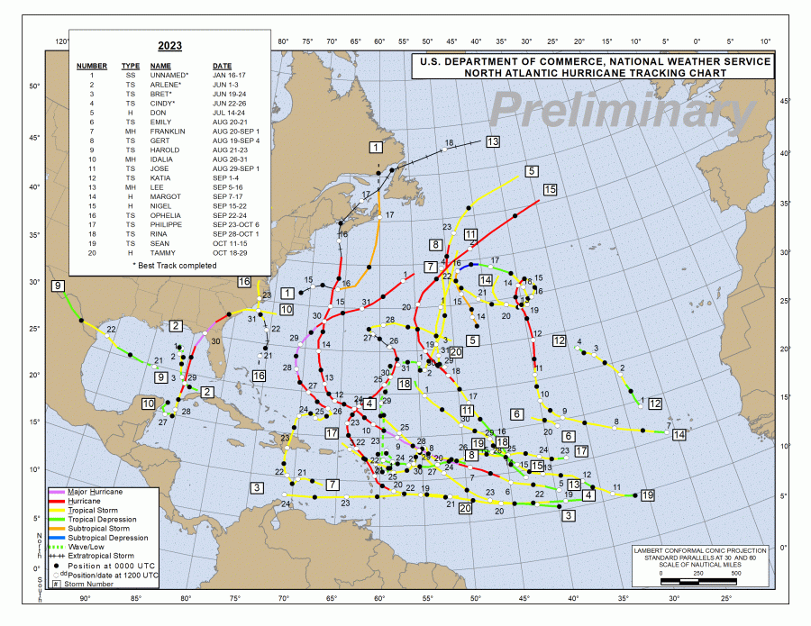
The 2023 Atlantic Hurricane Season occurred along the backdrop of a strong El Nino that strengthened into a very strong El Nino during Winter 2024.
Factors that played in the season’s favor included an active West African Monsoon and much warmer-than-average sea surface temperatures. There were 20 named storms, seven hurricanes and three major hurricanes.
Besides Hurricane Idalia and a few low-impact tropical storms, most places did not have any significant impacts. This is because the Azores-Bermuda High, which guides systems west across the Atlantic Ocean, was virtually nonexistent. This allowed storms to recurve far away from land. This is also a common feature of El Nino years, where storms recurve early and tend to form in the Subtropical Atlantic, farther away from ENSO influences.
2024 Atlantic Hurricane Season: What Are Forecasts, Observations and Models Saying Now?
An important disclaimer is this: This is purely an analysis of how the season MIGHT play out. This is not an official forecast for landfalls, overall activity, impacts etc.
Colorado State University, one of the nation’s most renown forecasting agencies, will release their forecast in April. The National Oceanic and Atmospheric Administration (NOAA) will release its official forecast in May.
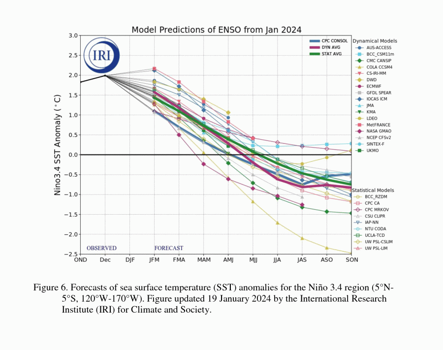
The current El Nino is weakening and has a 79 percent chance of transitioning to an ENSO-neutral state by Spring 2024, the Climate Prediction Center said Thursday. There is a 55 percent chance that La Nina conditions will be present by the peak of hurricane season, which runs from August through October.
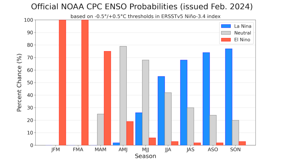
Currently, an El Nino advisory remains in effect, while there is now a La Nina Watch in effect.
At the same time, sea surface temperatures in the tropical Atlantic are running warmer than normal. Cooler-than-average temperatures are present south of New Foundland and in the subtropical Atlantic.
If this pattern persists into the hurricane season, it would foster an active season with storms possibly moving further west.
Since storms gain strength from warm sea surface temperatures, warmer waters are necessary. Cooler waters limit activity. Additionally, if the water is much warmer than average basin wide, this limits instability and storm activity.
Global climate models such as the NMME depict greater-than-average rainfall totals expanding through much of the Atlantic’s Main Development Region, which is the area between Western Africa and the Lesser Antilles.
These rainfall anomalies extend into the Caribbean and further west into the Western Atlantic and the Gulf of Mexico.
It is important to note that these do not necessarily correspond to future storm tracks.
In terms of ENSO effects on US landfalls, studies show El Nino events reduce landfalls along the Gulf Coast, East Coast and Florida Coast. The Gulf Coast is defined as anywhere expanding from the Florida/Alabama Border to Brownville, Texas. The Florida Coastline extends from the Florida/Alabama line, wrapping around to the Florida/Georgia Line. The East Coast is anywhere from Georgia northward.
The hurricane landfall frequency increases along the Gulf Coast and in Florida between El Nino and ENSO-neutral years, but this increase is not significant along the East Coast.
The frequency increase is insignificant along the Gulf and Florida coasts between ENSO neutral and La Nina years. Along the East Coast, there is a more significant increase.


Since Alabama is at risk from both Florida-landfalling and Gulf-landfalling storms, this will be one important pattern to watch as the season approaches.
A lot can and will change between now and the start of the 2024 Atlantic Hurricane Season. While this is not an official forecast, the First Alert Storm Team will continue to keep The Wiregrass up to date on all the latest weather-related information.
For the latest news, weather, sports, and streaming video, head to WDHN - wdhn.com.

