Charlotte braces for icy blast, outages and ‘impassable’ roads from weekend storm
Ice poses the greatest threat to Charlotte this weekend from a winter storm, with outages and “impassable roads” likely across the region, National Weather Service meteorologists said Friday.
Up to a half inch of ice with “light sleet and snow accumulations“ is expected in much of Charlotte and surrounding areas, NWS forecasters said in a winter storm alert at 4 p.m. Friday.
“The big deal for Charlotte is ice,” meteorologist Jake Wimberley of the NWS office in Greer, S.C., said.
Charlotte can expect an inch to 2 inches of snow and sleet as part of the wintry mix, and northern Mecklenburg County in the Lake Norman area 2 inches to 4 inches of snow and sleet, Wimberley said.
The brunt of the storm is predicted to hit Charlotte early Sunday and continue into until the afternoon, according to the 5 p.m. Friday NWS forecast. Sunday has a 100% chance of a wintry mix, forecasters said
A winter storm warning issued at 4 p.m. Friday by the National Weather Service begins at midnight Saturday and remains in effect until midnight Sunday.
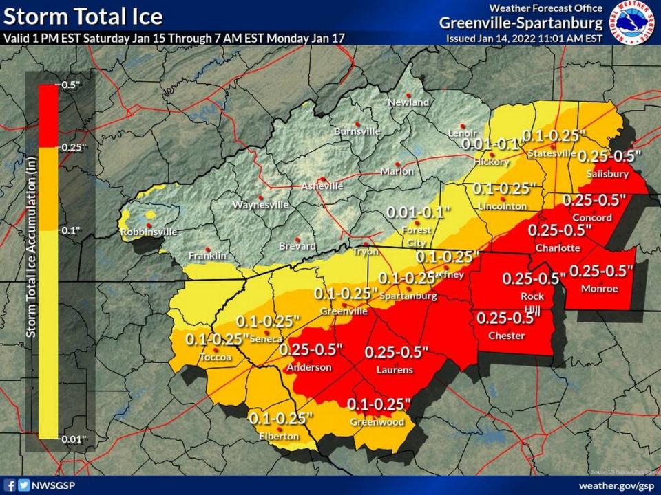
“Travel could be nearly impossible across the entire area,” NWS meteorologists said in a bulletin announcing the winter storm warning. “At least scattered power outages and tree damage are likely across the Piedmont due to the ice as well as gusty winds.”
Gusts in Charlotte could reach 35 mph, according to the NWS.
Emergency officials said they are ready to respond to wrecks, outages from ice-downed trees, and power lines and other winter weather events.
“It’s all hands on deck,” Mecklenburg EMS spokeswoman Grace Nelson said Friday.
Black ice a concern for region
Snow totals predicted by the NWS office in Greer, S.C., trended down for the Charlotte area on Friday, with a mix of all precipitation types expected closer to the Interstate 85 corridor and mostly freezing rain for areas southeast of I-85.
The I-85 corridor includes Mecklenburg, Cabarrus and Rowan counties and, in South Carolina, the Gaffney-Spartanburg areas, according to the NWS.
The precipitation, perhaps as light snow, should taper off Sunday evening. But black ice could make driving dangerous each morning early next week, NWS forecasters said.
Anywhere from 8 to 18 inches of snow is likely in the North Carolina mountains over the weekend.
The latest forecast calls for the Charlotte area to start seeing snow between midnight and 4 a.m. Sunday, then snow and sleet until noon and freezing rain between noon and 4 p.m. Rain, or freezing rain, is likely after 4 p.m. with the high a chilly 33 degrees.
The approaching storm prompted a plea by Mecklenburg County Animal Control for people to visit the animal shelter on Saturday to take a shelter dog on a “winter weather staycation,” as the shelter is again full of dogs.
Record snow is making moose cranky and dangerous, Alaska park says. ‘Be ready to run’
74.5 inches of snow? Multiple weather records smashed at one Alaska national park
Trooper seen dodging oncoming car on Wyoming video is compared to an NFL running back
Staff writers Jonathan Limehouse and Evan Moore contributed.

