Chimney Rock Trail offers Red cliffs, wildlife and panoramic views of Oregon's high desert
When a western Oregonian travels to the dry side of the Cascade Range, it has a similar effect to a time portal, or a starship, or maybe something in between. It’s a three-hour trip to a whole new world in a galaxy far, far away. It’s a journey that replaces our moss, thick foliage and fir forests with lichen-covered basalt cliffs, sagebrush and ponderosa pine.
If you’ve gone to the east side, you know exactly what I mean. And it’s something some Willamette Valley residents crave. With snow less of an issue on the mountain passes, and summer on its ways in Central Oregon, now is an ideal time to make the trip.
The 2.6-mile out-and-back Chimney Rock Trail, 18 miles south of Prineville, is the perfect way to experience the unique beauty of spring in Central Oregon.

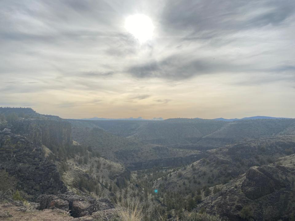
Located in the Crooked River area along Highway 27, this trail offers a gradual climb through forested canyons and cliffs up to a cylinder-shaped vista. Its namesake summit towers over the stunning Crooked River canyon with panoramic views of the Cascades that make it the ideal sunset hike for long, warm May days.
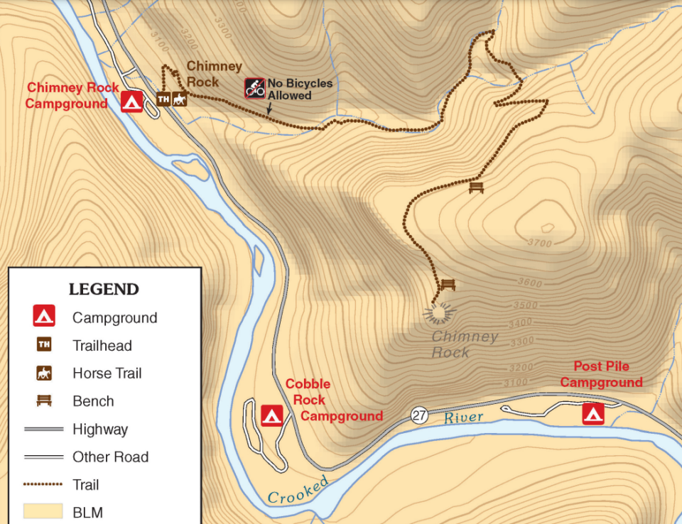
A map of the trail, as well as additional information on the area, can be found at on.doi.gov/3AWRqKs.
The trail is open year-round but is best enjoyed in the spring and fall when moisture tampers the dusty desert ground and air. The trail is located along the lower Crooked River just below the Bowman Dam. This prized section of public land offers several campgrounds, including the Chimney Rock Campground. Other common attractions in the area include fly fishing, kayaking and birding.
Rattlesnakes and desert views
You begin the hike by parking at a day use area, which is across Highway 27 from the Chimney Rock Campground. The trail, which is the only one available from the parking area, can be found directly left of the map and information plaques.
The trail is gradually sloped and easily visible throughout. It is rocky and dusty with plenty of loose gravel and stones, so wear comfortable hiking boots with decent ankle support.
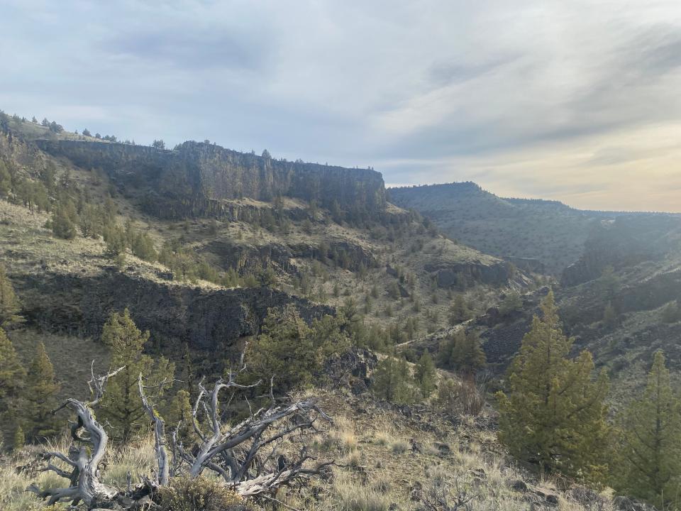
This moderately challenging route features a 623-foot elevation gain before plateauing near the namesake monument. In the first 0.75 miles, you’ll hike through a forested canyon surrounded by juniper and ponderosa pine trees. If you look carefully through the sagebrush understory, you’ll spot lizards, snakes and animal tracks.
Searching for a slightly enhanced view of the canyon, my hiking partner and I edged our way through a slim gap in the sagebrush where some mule deer had clearly traversed before. About 10 feet off the trail, I heard two noises: several high-volume expletives from my friend, and a sound no hiker wants to hear loud and clear.
Rattle, rattle, rattle
My friend saw the rattlesnake. I did not. The snake let us know it was there and got out of sight. But here's the point: it's the desert. There are going to be snakes. As long as you keep that in mind while on the trail, and listen for their very fair and often loud warnings, there's nothing you need to worry about.
After turning the switchback at around the 0.8-mile mark, you’ll find yourself walking along a cliff’s edge for the remainder of the ascent to the Chimney Rock lookout. This section offers stellar views of the canyon, river and Cascade Range but minimal tree cover, so be sure to wear sunscreen.
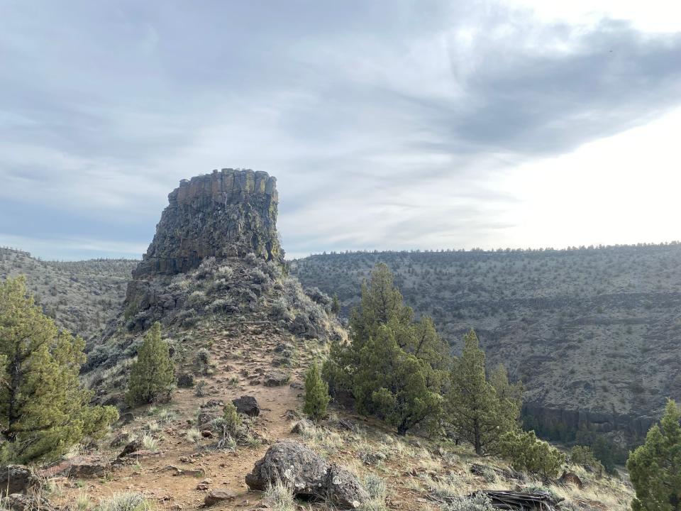
The final half mile of the hike features a gentle incline with numerous stopping points. Be sure to bring your binoculars, as this section is perfect for birding and wildlife viewing. The last stretch of the trail plateaus along the cliff before winding down 60 feet to the base of the Chimney Rock. The basalt rock structure is highly vertical and brittle, so no access to its pinnacle is available and climbing is discouraged.
The base of the Chimney Rock marks the end of the trail, where you can enjoy a break, a drink of water and take in the stark desert scenery before heading back down the way you came. The way down will be mellow, but tread with caution as loose rocks can be especially problematic when traveling downhill.
If you’re seeking a hands-on tour of the geology, wildlife and breathtaking scenery of Oregon's high desert, check out the Chimney Rock Trail along the Crooked River scenic corridor. You won’t regret it.
Chimney Rock Trail
In a nutshell: A prominent desert viewpoint accessible by day hike.
Trip: 2.6 miles out-and-back.
Location: 18 miles south of Prineville on Highway 27.
Trailhead: Chimney Rock Trailhead, Highway 27.
Weather: Chimney Rock is in the desert and can be intensely hot and dry, so bring ample water, dress comfortably and wear sunscreen on sunny days. Start early to avoid peak heat if hiking in the late spring and summer.
When to go: This trail is moderately trafficked, but if you want the place to yourself, go on a weekday.
Fee: No fee.
Map: on.doi.gov/3AWRqKs
Directions: Follow Highway 126 from Sisters for 37 miles. Turn right on Second Street in Prineville and in a half mile, take a right on Highway 27. Follow the road for 18 miles south before reaching the destination on your left.
Charles Gearing is an outdoors journalism intern for the Statesman Journal. He can be reached at cgearing@gannett.com.
This article originally appeared on Salem Statesman Journal: Chimney Rock offers one of Central Oregon's best desert hikes

