Cincinnati spent $120M to build Smale Park. It needs more for its eroding shoreline
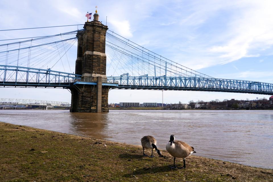
The Ohio River is eating away the shoreline of Smale Riverfront Park.
With protective trees and brush removed more than 15 years ago to build the downtown site, the constant ebb and flow of the river has eroded the park's western-most border and made long-planned repairs critical.
“Nothing is under threat yet,” Cincinnati Parks Director Jason Barron said of the danger posed by the erosion. But, he said, “If we do nothing, the day will come.”
A fix is in the works. Possible designs emerged last week. To move forward, the city needs $15 million promised by the federal government.
Smale is the ‘front door to our city’
Parks officials consider Smale a crown jewel among Cincinnati’s 100-plus park facilities. They also acknowledge it was among the costliest at about $120 million. Of that, at least $30 million came from local taxpayers, $20 million from one-time Procter & Gamble chief John G. Smale and the rest from other public and private sources, records show.
Planned since 1997 and dedicated in 2012, Smale spans 45 acres along downtown’s Mehring Way, the Bengals’ Paycor Stadium at its west end, the Reds’ Great American Ball Park at its east border.
Filled with lush landscaping, water features, playgrounds and gathering spaces, “Smale Riverfront Park is the front door to our city,” Barron said.
Attention to its frayed edge has been delayed by other priorities and changing administrators.
Barron signed on as parks director in September 2022 – the sixth full-time or temporary person in the job since 2017 – and took his first meeting on the erosion issue the next month.
Since then, he and his staff have been working with the U.S. Army Corps of Engineers, the federal agency that regulates U.S. waterways, toward solutions.
“This is the next phase,” Barron said. “It’s now time for that.”
Feds may absorb full cost of fixes
Congress OK’d $15 million in federal funding in 2016 for continued development at Smale – including restoration and flood risk reduction – under a water infrastructure bill. The legislation required a matching commitment from local sources.
In 2019, the city of Cincinnati and Hamilton County signed an agreement with the Corps of Engineers that essentially wipes out their matching obligation. Under their memo of understanding, the three parties agreed the city and county can count the $35 million they've spent to develop two lots along Mehring Way as their contribution under the 2016 law, parks documents and officials confirm. The lots are now home to the Andrew J. Brady Music Center and its outdoor Icon Festival Stage.
Parks' matching contribution will also include about $4.5 million in spending under way right now for finishing touches near the music venues. Those dollars – about $3.25 million of them from donors, via the Cincinnati Parks Foundation – will cover the cost of planters, bench seating, pergolas, granite facings and a donor wall at the center of an earlier dispute.
Assuming the 2019 agreement sticks, the city will only be on the hook for about $1.25 million more. That's half the cost of a feasibility plan that Army Corps requires to release the earlier-authorized federal dollars. Parks has already paid $300,000 of that and thinks the total bill could end up being less.
If parks wants features at Smale beyond what the federal budget covers, however, officials will need to find new local dollars, Barron said.
Four approaches under consideration
Even as the feasibility plan is being drafted, the Army Corps released four possible designs to fix and stop the erosion. Each incorporates 2.75 to 3 acres of Smale property, running 1,200 feet west from the John A. Roebling Suspension Bridge.
Barron presented them to the Park Board during its Feb. 15 monthly meeting:
One rendering features a river walk, granite seat walls and lawn with native grasses and other plantings.
A second includes a wall of rocks (called “riprap”) along with walkways and seat walls.
A third features a concrete serpentine wall, stepped down toward the water.
The fourth includes a more narrow set of stairs to the water, with walkways and seat walls.
Parks and federal officials expect to settle on the best design by next summer, Barron told Park Board commissioners.
“This is great we’re this far along,” Board President Jim Goetz said. “It’s exciting to see graphics.”
The design will dictate the final price tag, Joel Gross, division manager of planning and design, told the board.
Barron said he and his staff like the concept with the most plantings best, but anticipate a plan with “multiple methods” to combat erosion.
Without help, ‘Mother Nature will win’
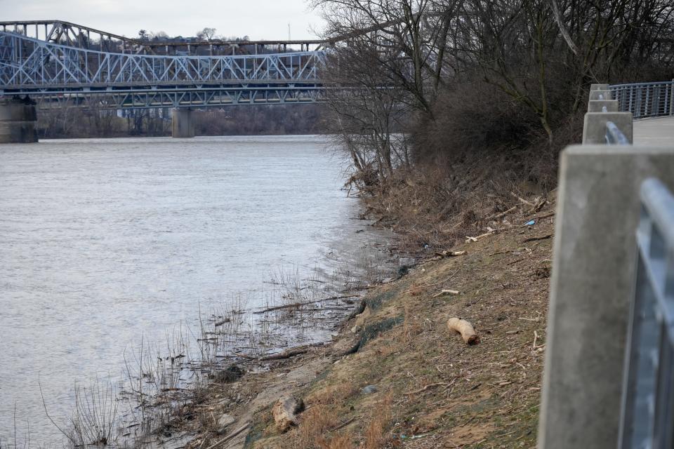
When Barron brought new members of the park board to Smale’s edge last year, he stood about 5 feet below them along a sheered-off section of the shore. The water was some 25 feet beyond the park’s sidewalk.
On a Feb. 1 tour this year, with the Ohio River standing at 48 feet, water creeped a dozen feet closer to the sidewalk, covering the erosion.
This week, with river under 30 feet, the erosion was once again bare – along with a car tire, abandoned cooler and range of of plastic debris.
The decorative metal fencing between the west end of Smale and the river is not compromised, parks officials said. But they acknowledge that the steep drop-off is a fall hazard.
Without intervention, Barron said, “Mother Nature will win.”
Parks wants what it picks for Smale to bring park users – people with fishing poles, people in canoes, people who use wheelchairs – to the water’s edge.
“I want a kid to be able to splash his brother,” Barron said.
What do you want at Smale? Parks officials are collecting ideas with this survey.
This article originally appeared on Cincinnati Enquirer: How will Cincinnati Parks fix Ohio River erosion near Smale Park?

