Clipper storm to raise risk of dangerous snow squalls for motorists in Midwest, Northeast

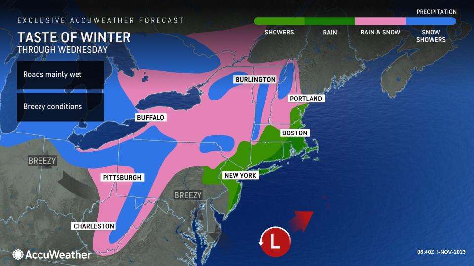
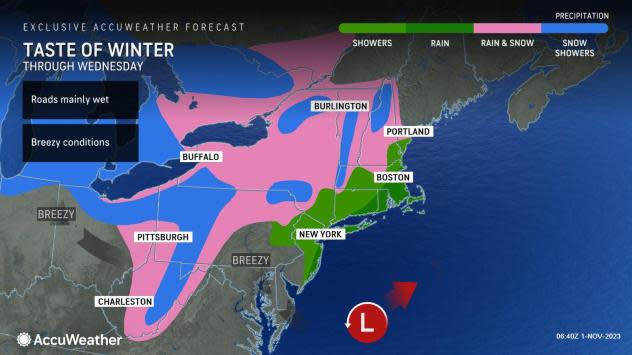
A blast of air more typical of early December will be accompanied by a type of storm notorious for triggering snow flurries, lake-effect snow and sudden snow squalls and that will continue to spread across the interior Northeast at midweek, AccuWeather meteorologists warn.
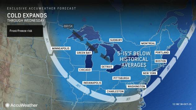
Not only will temperatures be 30 to 50 degrees Fahrenheit lower when compared to the peak of the warmth from its past week and weekend, but snowflakes will be flying in much of the Upper Midwest and the interior Northeast. Highs in the 60s, 70s and 80s have been swapped with highs in the 30s and 40s and nighttime lows in the teens, 20s and 30s.
 |
In most cases, the flurries and snow showers will merely bring a reminder of the season just ahead. However, some of the heavier snow showers, known as snow squalls, could pose a serious problem for motorists, especially when the snow hits during times of heavy traffic and brings a sudden drop in visibility.
Snow squalls are closely related to the well-known warm weather weather phenomenon -- thunderstorms. Most snow squalls do not bring thunder and lightning, unlike their summertime cousin, but are capable of unleashing localized heavy precipitation.
The type of storm system that will rally the flurries, snow showers and heavier snow squalls is known as an Alberta Clipper. This fast-moving storm, which originates from western Canada, often dives into the Midwest and Northeast and is typically accompanied by cold air and gusty winds.
"Figuring road conditions during early-season snowfall events such as this week's clipper storm is always tricky due to the warm ground and the effect it has on quickly causing the snow to melt as it falls," AccuWeather Senior Storm Warning Meteorologist Brian Wimer said, adding, "However, the nature of snow squalls can bring a quick, small slushy accumulation that can lead to dangerous conditions on the highway."
An abrupt temperature drop often accompanies snow squalls, which can help snow accumulate on paved surfaces long enough to lead to a potential pile-up. In some cases, by the time crews arrive on the scene, the snow has already melted from the highway.
Timing of the snow squalls may be critical for the risk of an accumulation on roads in late October and early November. For example, a snow squall that hits at the start of the day or toward evening and the overnight hours is more likely to bring slick conditions than during the middle of the day. However, there can be some exceptions.
Up to 6 inches of snow fell on parts of Minnesota and northern Wisconsin from Monday night to Tuesday morning. The Minneapolis metro area picked up between 2 and 3 inches of snow, according to the National Weather Service. Snow piled up along the eastern shores of Lake Michigan with 8-12 inches falling as of Wednesday morning.
Wimer added that the most likely zone for a general small accumulation of snow is over some of the higher terrain over the interior Northeast from West Virginia to Pennsylvania, New York, Vermont and New Hampshire through Wednesday night.
A small accumulation is possible a bit farther to the south and at lower elevations, where any snow squall happens to become intense, Wimer said.
Even where the snow is not likely to accumulate, such as along much of the Interstate 80 corridor from northern Illinois to the northern parts of Indiana, Ohio, Pennsylvania and New Jersey, the quick-hitting nature of the snow showers and squalls can create dangerous conditions. The sudden drop in visibility alone and reduced braking action can increase the risk of multiple vehicle accidents.
 |
There will still be stretches along I-80, as well as I-70 and I-90 that can get slippery. Parts of northeastern Ohio, western and northern New York state and the high ground in Pennsylvania along I-80 could also see the snow accumulate a couple of inches and linger for a time.
In the Northeast, the risk of locally heavy snow showers in major cities will generally be limited to Erie, Pennsylvania, and Buffalo, Rochester and Watertown, New York into Tuesday night. A touch of snow fell around Pittsburgh Tuesday night, while bursts of snow left up to 8 inches in northeastern Ohio and close to 10 inches over the interior of northwestern Pennsylvania during early Wednesday morning.
As the snow showers and squalls pivot across the interior Northeast, airline delays are likely due to deicing operations.
A storm offshore strengthened just enough to allow a period of wet snow over the higher elevations from of southwestern New England through Wednesday morning. The higher elevations of the Berkshires in western Massachusetts and northwestern Connecticut picked up 1-3 inches of wet snow on non-paved surfaces. The steady snow in the Berkshires will diminish Wednesday afternoon, but snow showers may still occur into the evening hours.
It is conceivable that some of the northern and western suburbs of the major I-95 cities from New York City and Boston will see some wet snowflakes briefly mixed in with sprinkles associated with the coastal storm and/or the clipper storm into Wednesday afternoon.
In the wake of the clipper storm in the Midwest on Wednesday and the Northeast on Thursday, temperatures will turn around a bit and may briefly swing back to above historical averages, which will end the risk of snow showers.
Want next-level safety, ad-free? Unlock advanced, hyperlocal severe weather alerts when you subscribe to Premium+ on the AccuWeather app. AccuWeather Alerts™ are prompted by our expert meteorologists who monitor and analyze dangerous weather risks 24/7 to keep you and your family safer.
