How close is Black Fire to Hillsboro, Gila Cliff Dwellings, Silver City? See updates
SILVER CITY - Though the Black Fire in the Gila National Forest continues to grow, so do containment levels.
As of Monday, May 30, the blaze had charred 241,403 acres and was 26 percent contained. Heading into the weekend, firefighters had contained 13 percent of what was then a 191,459-acre fire.
About 750 personnel are dedicated to fighting the blaze, the third largest in state history. The wildfire is burning in a largely uninhabited portion of the forest and has consumed two structures.
The official fire report notes much of the containment is happening on the western front. Crews continue firing operations on the northwest side, establishing containment lines from Forest Road 150 east. The blaze is growing to the south — where it's burning in the Silver Fire scar toward McKnight and Lake mountains — and the east — where it remains active in the Mineral Creek area and is expected to spread in the Palomas Creek drainage.
How the blaze started is under investigation, but suspected to be "human-caused," according to the report.
How far is the Black Fire from towns?
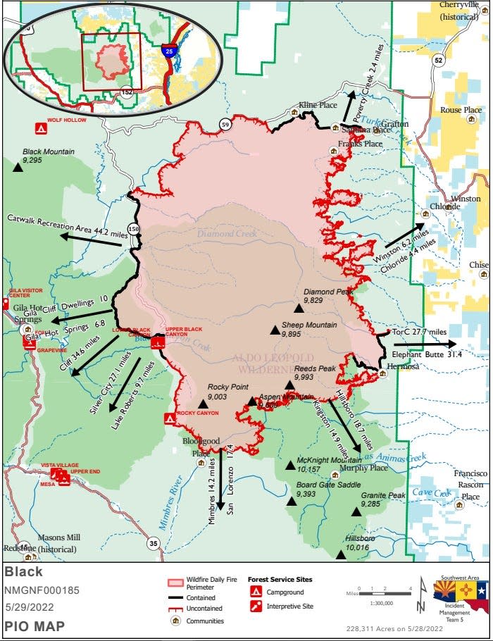
Gila National Forest released a map Sunday, May 29, showing how far the Black Fire is from landmarks and population centers. There is also an interactive evacuation map pinpointing structures nearby the fire.
The interactive map shows several homes along Poverty Creek, about 2.4 miles north of the blaze. There are also a number of homes in the Mineral Creek area close to the historical towns of Chloride and Winston, which are 4.4 miles and 6.2 miles, respectively, east of the current fire line. The structures along Poverty Creek and Mineral Creek are most in danger.
Kingston and Hillsboro, along US 152 and south of the Black Fire, are likely the most well known areas in the Black Range of the forest. Further to the west, but still south of the Black Fire, are Mimbres and San Lorenzo. All four small towns are between 14 and 19 miles away from the wildfire.
More: US review traces massive New Mexico fire to planned burns
The Gila Hot Springs are 6.8 miles west of the Black Fire, and the Gila Cliff Dwellings National Monument is 10 miles west of the fire, though the fire is largely contained on this side.
The largest population centers threatened by the fire are Silver City, which is 27.1 miles southwest of the Black Fire, and Truth or Consequences, which is 27.7 miles east of the blaze.
Evacuation orders and closures
Grant, Catron and Sierra county sheriff offices announced evacuations for areas near the fire. Ready, Set, Go evacuation statuses are on the official fire report page.
Highway 59 is closed from Mud Hole to the 59/150 intersection. Forest Road 150 is also closed at the North Star Helispot. Interstate 25 and other state highways remain open. A portion of the Gila National Forest affected by the fire has been closed.
Lucas Peerman can be reached at lpeerman@lcsun-news.com or @LittleGuyInATie on Twitter.
This article originally appeared on Silver City Sun-News: See a map of Black Fire and its proximity to Hillsboro, Silver City

