November thunderstorms fire up and bring hail to parts of southern Ontario
Get ready for an up-and-down sort of week across Ontario as we’re monitoring two impactful systems that’ll bring foul weather to the province over the next few days.
Our first system arrived late Sunday and will persist into Monday with a wide range of conditions throughout the region. Heavy snow in the north will sharply contrast with gusty winds and unseasonable warmth in the south.
It’s the second system, though, that warrants closer attention, as the developing storm could grow into a sprawling disruption for much of the province.
MUST SEE: Canada's November outlook: A smooth transition or a free fall into winter?
A clipper’s long journey brings a spectrum of weather to Ontario
A troublesome clipper pushing into Ontario to begin the week has caused problems since its heyday back on the West Coast, dropping heavy rain, formidable snows, and even a crust of ice along its path.
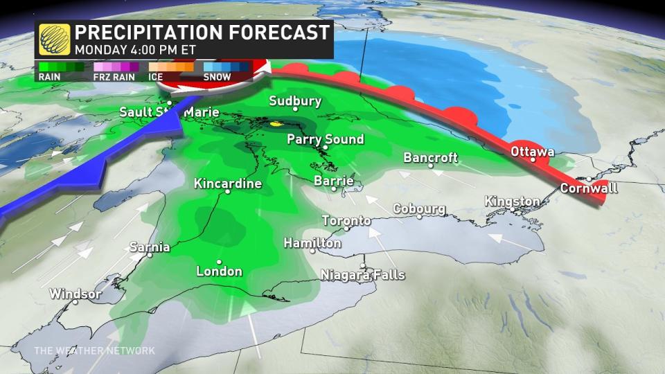
The system pushed into Ontario late Sunday with a swath of heavy snow for communities up north. Widespread snowfall warnings are in effect as a quick 10-20 cm of snow will fall between Kenora and Kapuskasing.
Some particularly treacherous routes include Highway 17 near Dryden and along Highway 11 between Geraldton and Kapuskasing, where up to 20 cm of snow is forecast to fall locally.
Warm winds funneling into the heart of the low-pressure system will force snow to change over to rain across cottage country, while precipitation may briefly begin as snow in eastern Ontario before the changeover to plain rain.
SEE ALSO: Canada’s cold air brings Mexico some of Earth’s most violent winds
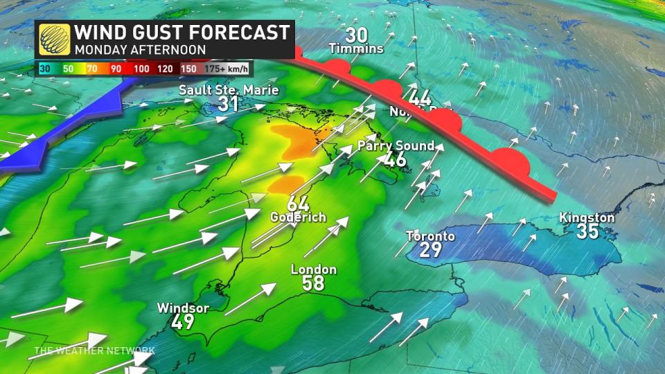
Those warm southerly winds will grow quite feisty at times, with 70+ km/h gusts possible in southwestern Ontario, especially around the shores of Lake Huron and Georgian Bay.
We’ll see unseasonably warm temperatures through the day Monday as that milder air surges north across the border. Daytime highs will come in as much as 5+ degrees above seasonal for the first week of November.

Rain will push into southern Ontario during the day Monday as the clipper’s cold front begins to push into that slug of warmer air streaming over the region.
Temperatures will dive into the single digits behind the clipper, setting the stage for our next system arriving late Wednesday into Thursday.
Uncertainty abound as a complex storm setup arrives Thursday
The progress of two systems through the week will dictate the conditions Ontario will contend with toward the end of the week.
Forecasters are watching the development of a Colorado low south of the border and a clipper expected to move across the Prairies.

Both of these systems will arrive in the Great Lakes region on Thursday. How the two disturbances interact with each other will determine how conditions play out.
Computer models are struggling a bit with the complex interaction between these two systems, as one system dominating over the other will have big implications for Ontario's weather.
Either way, this looks like it could be a more impactful snow event in northern Ontario, with the potential for prolonged freezing rain in central Ontario.

It doesn’t look like a winter weather event for the Greater Toronto Area right now, but forecasters will closely monitor the southern extent of snow and freezing rain to see how close it gets to the region.
Stay with The Weather Network and check back frequently in the days ahead for the latest on this midweek system and how it may affect your community and your travels this week.
Thumbnail courtesy of Hailey Vandaele, taken in Woodstock, Ont.

