A cold front may help the Mississippi Coast steer clear of a Category 3 hurricane
Cooler temperatures could not come at a better time for the Mississippi Coast.
Forecasters say a cold front expected Monday will push any signs of Tropical Depression 9, away from the area.
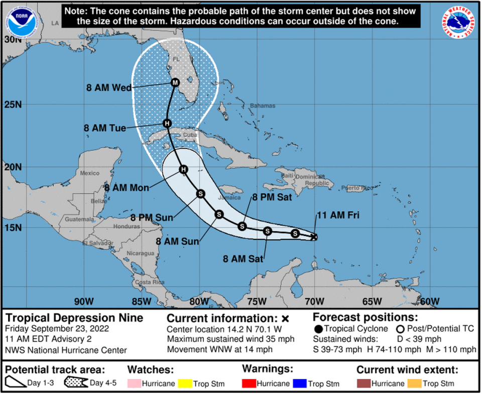
The storm system is expected to intensify to a Category 3 hurricane in the Gulf next week before landfall. South Florida is currently in the National Hurricane Center’s track cone, and the next storm name is Ian.
“Confidence has increased this morning that the eastern U.S. trough and Monday`s cold front will keep newly formed Tropical Depression Nine (TD 9) currently in the Caribbean Sea to the east of our area,” said the National Weather Service Friday morning.
The NWS also warned that until the tropical depression exits the Caribbean Monday night or Tuesday, it would be wise to continue to monitor its path.
Tropical Depression 9 forms in Caribbean and could become Hurricane Ian in the Gulf
The storm system is “not currently expected to be a significant threat to SE LA or S MS, but continue to monitor as the forecast beyond Monday is a bit more uncertain than usual,” NWS New Orleans tweeted.
The expected cold front will mean cooler, drier air starting Monday and lasting at least through Thursday in the Biloxi area.
“Forecast soundings would indicate that by Wednesday and Thursday, highs will be a good 15 degrees Fahrenheit cooler than over this weekend,” said NWS.
The drop could be as much as 20 degrees. Overnight temperatures will likely be in the 50s with daytime temperatures hovering around around the low 80s or high 70s. “The normally cooler locations (Pearl and Pascagoula River drainages) could even drop into the upper 40s briefly,” said NWS.