Cold front moving toward Florida behind line of storms that could bring severe weather
A "powerful" cold front is forecast to move into Florida behind a line of storms that bring with them the threat of tornadoes and large hail, according to the Florida Public Radio Emergency Network.
The front will drop temperatures by as much as 30 degrees in some locations as it brings with it a threat for lightning storms. Some could become strong to severe, according to the National Weather Service, Melbourne.
That's nothing compared to what almost 15 million people across the U.S. are facing, as a winter storm packing 80-mph wind gusts and snow prompt blizzard and winter storm warnings.
'Whiteout conditions' Winter storm could fuel blizzard conditions, travel havoc across swath of US
Flight delayed?If your flight is delayed, you may be eligible for compensation from your airline
"This system will then stall across the central Plains into Thursday, producing several days of heavy snow and blowing snow, including blizzard conditions, and freezing rain extending into the Upper Midwest," the National Weather Service Storm Prediction Center said in its advisory.
"Severe thunderstorms, tornadoes, and flooding will be possible in the South."
The storm prediction center also warned "bitterly" cold temperatures are likely to impact the lower 48 states leading up to and continuing from Dec. 20 and Dec. 26.
Rain chances increase in Florida toward the end of the week, along with the cooler temperatures, according to the National Weather Service, Jacksonville.
Conditions will be favorable for a few storms to become strong to severe. The primary threats will be strong wind gusts and frequent lightning strikes.
When is the cold front expected to move into Florida?
Storms are forecast to move into the Panhandle Wednesday evening, and move to the east overnight, arriving in the Tallahassee area early Thursday morning.
Across Central Florida, the severe risk will likely linger into the early evening Thursday before storms move into the Atlantic.
There will be a slight chance of thunderstorms in South Florida ahead of the front late Thursday evening into Friday morning, according to the National Weather Service, Miami.
What are the main storm threats expected ahead of the cold front?
Damaging winds and a threat for tornadoes are the primary threats currently forecast, especially in the Panhandle, according to the Florida Public Radio Emergency Network.
The risk for damaging winds and an isolated tornado will likely continue across the state into early Thursday evening.
Across east central Florida, the primary threats will be strong wind gusts and frequent lightning, according to the National Weather Service, Melbourne.
There is the potential for watches and warnings Wednesday and Thursday.
How low will temperatures drop across Florida?
A significant cooldown is expected from the Panhandle to Central Florida after severe storms move through. Highs for the weekend are forecast to drop into the 50s across the Panhandle, and into the lower and middle 70s across South Florida.
Highs could drop over the week by as much as 20 degrees in some locations in the Panhandle and North Florida.
Lows could dip by almost 30 degrees, into the upper 30s. Tallahassee's low of 68 projected for Wednesday could drop to 39 by Saturday.
Farther south, the dip could mean low temperatures dropping into the upper 40s by Friday along the East Coast. Temperatures are forecast to drop into the low to mid 50s along the West Coast.
In South Florida, lows are projected to drop by a few degrees into the mid 60s, although Naples could hit a low of 56 by Sunday.
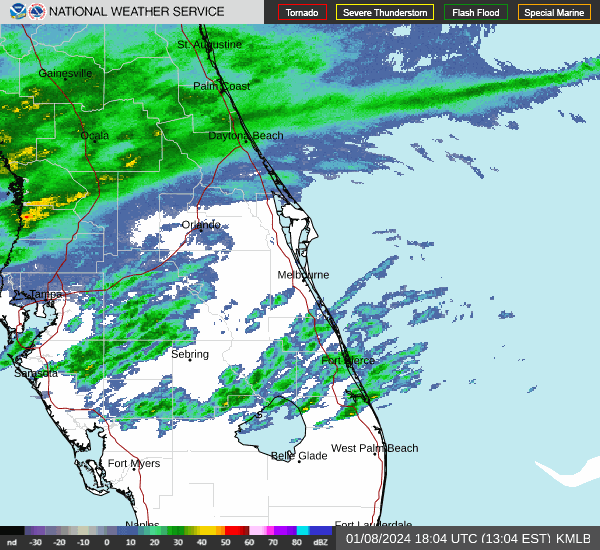
Weather radars and forecasts across Florida

At a glance
Day | High | Low | Rain chances |
Wednesday | 75 | 54 | 80%-100% |
Thursday | 64 | 45 | 70% |
Friday | 61 | 43 | |
Saturday | 57 | 43 | 20% |
Sunday | 56 | 46 | 20% |
Detailed Pensacola forecast
Wednesday: Showers likely and possibly a thunderstorm, then showers and thunderstorms after 7 a.m. High near 75. Southeast wind 10 to 15 mph, with gusts as high as 30 mph. Chance of precipitation is 80%. New rainfall amounts between a quarter and half of an inch possible.
Wednesday night: Showers and thunderstorms. Low around 54. South wind 10 to 15 mph becoming west after midnight. Winds could gust as high as 40 mph. Chance of precipitation is 100%.
Thursday: Showers and thunderstorms likely before 7 a.m. Sunny, with a high near 64. Northwest wind around 10 mph, with gusts as high as 25 mph. Chance of precipitation is 70%.
Thursday night: Clear, with a low around 45. Northwest wind 5 to 10 mph.
Friday: Sunny, with a high near 61. West wind around 10 mph.
Friday night: Partly cloudy, with a low around 43. Northwest wind around 10 mph.
Saturday: Partly sunny, with a high near 57. North wind around 10 mph.
Saturday night: A 20 percent chance of rain after 7pm. Partly cloudy, with a low around 43.
Sunday: A 20 percent chance of showers. Sunny, with a high near 56.
Sunday night: A 20 percent chance of showers. Partly cloudy, with a low around 46.

At a glance
Day | High | Low | Rain chances |
Wednesday | 73 | 68 | 30%-90% |
Thursday | 71 | 43 | 60% |
Friday | 63 | 40 | |
Saturday | 59 | 39 | 20% |
Sunday | 56 | 39 |
Detailed Tallahassee forecast
Wednesday: A 30 percent chance of showers and thunderstorms after 1p.m. Mostly cloudy, with a high near 73. South southeast wind 5 to 10 mph, with gusts as high as 20 mph.
Wednesday night: Showers and thunderstorms, mainly after 1 a.m. Steady temperature around 68. South southeast wind around 10 mph, with gusts as high as 30 mph. Chance of precipitation is 90%.
Thursday: Showers and thunderstorms likely, mainly before 1 p.m. Cloudy through mid morning, then gradual clearing, with a high near 71. South southwest wind 5 to 10 mph becoming west northwest in the afternoon. Winds could gust as high as 30 mph. Chance of precipitation is 60%.
Thursday night: Mostly clear, with a low around 43.
Friday: Sunny, with a high near 63.
Friday night: Mostly clear, with a low around 40.
Saturday: Mostly sunny, with a high near 59.
Saturday night: A 20 percent chance of showers and thunderstorms before 1am. Partly cloudy, with a low around 39.
Sunday: Sunny, with a high near 56.
Sunday night: Partly cloudy, with a low around 39.

At a glance
Day | High | Low | Rain |
Wednesday | 76 | 65 | 20% |
Thursday | 75 | 48 | 90% |
Friday | 65 | 42 | |
Saturday | 62 | 41 | |
Sunday | 58 | 42 |
Detailed Jacksonville forecast
Wednesday: Mostly cloudy, with a high near 76. Southeast wind 9 to 11 mph.
Wednesday night: A 20 percent chance of showers after 1 a.m. Mostly cloudy, with a low around 65. South wind 9 to 11 mph.
Thursday: Showers and thunderstorms. High near 75. Breezy, with a southwest wind 13 to 16 mph. Chance of precipitation is 90%.
Thursday night: Partly cloudy, with a low around 48.
Friday: Sunny, with a high near 65.
Friday night: Mostly clear, with a low around 42.
Saturday: Sunny, with a high near 62.
Saturday night: Partly cloudy, with a low around 41.
Sunday: Mostly sunny, with a high near 58.
Sunday night: Partly cloudy, with a low around 42.
At a glance
Day | High | Low | Rain |
Wednesday | 77 | 65 | |
Thursday | 79 | 53 | 30%-70% |
Friday | 66 | 48 | |
Saturday | 63 | 47 | 20% |
Sunday | 61 | 50 | 20% |
Detailed Daytona Beach forecast
Wednesday: Partly sunny, with a high near 77. South southeast wind 5 to 10 mph.
Wednesday night: Mostly cloudy, with a low around 65. South southeast wind around 10 mph.
Thursday: Showers likely and possibly a thunderstorm. Mostly cloudy, with a high near 79. South wind 10 to 15 mph, with gusts as high as 25 mph. Chance of precipitation is 70%.
Thursday night: A 30 percent chance of showers and thunderstorms. Mostly cloudy, with a low around 53. Southwest wind around 10 mph becoming west northwest after midnight.
Friday: Sunny, with a high near 66. Northwest wind around 10 mph.
Friday night: Mostly clear, with a low around 48. West northwest wind 5 to 10 mph.
Saturday: Sunny, with a high near 63. North northwest wind around 10 mph.
Saturday night: A 20 percent chance of showers. Mostly cloudy, with a low around 47. Northwest wind 5 to 10 mph.
Sunday: A 20 percent chance of showers. Mostly sunny, with a high near 61. North wind 10 to 15 mph.
Sunday night: A 20 percent chance of showers. Partly cloudy, with a low around 50. North wind around 10 mph.
Wednesday: Mostly sunny, with a high near 79. South southeast wind 10 to 15 mph, with gusts as high as 20 mph.
Wednesday Night: Partly cloudy, with a low around 67. South wind around 10 mph.
Thursday: A 40 percent chance of showers and thunderstorms. Partly sunny, with a high near 83. South wind 10 to 15 mph, with gusts as high as 25 mph.
Thursday Night: A chance of showers and thunderstorms. Mostly cloudy, with a low around 62. Southwest wind around 10 mph. Chance of precipitation is 50%.
Friday: Mostly sunny, with a high near 72. Northwest wind 10 to 15 mph.
Friday Night: Mostly clear, with a low around 53. Northwest wind around 10 mph.
Saturday: Sunny, with a high near 68. North northwest wind around 10 mph.
Saturday Night: Partly cloudy, with a low around 53. North northwest wind around 10 mph.
Sunday: A 20 percent chance of showers. Mostly sunny, with a high near 69. North northeast wind around 10 mph.
At a glance
Day | High | Low | Rain |
Wednesday | 77 | 65 | |
Thursday | 79 | 53 | 30%-70% |
Friday | 66 | 48 | |
Saturday | 63 | 47 | 20% |
Sunday | 61 | 50 | 20% |
Detailed Melbourne forecast
Wednesday: Partly sunny, with a high near 77. South southeast wind 5 to 10 mph.
Wednesday night: Mostly cloudy, with a low around 65. South southeast wind around 10 mph.
Thursday: Showers likely and possibly a thunderstorm. Mostly cloudy, with a high near 79. South wind 10 to 15 mph, with gusts as high as 25 mph. Chance of precipitation is 70%.
Thursday night: A 30 percent chance of showers and thunderstorms. Mostly cloudy, with a low around 53. Southwest wind around 10 mph becoming west northwest after midnight.
Friday: Sunny, with a high near 66. Northwest wind around 10 mph.
Friday night: Mostly clear, with a low around 48. West northwest wind 5 to 10 mph.
Saturday: Sunny, with a high near 63. North northwest wind around 10 mph.
Saturday night: A 20 percent chance of showers. Mostly cloudy, with a low around 47. Northwest wind 5 to 10 mph.
Sunday: A 20 percent chance of showers. Mostly sunny, with a high near 61. North wind 10 to 15 mph.
Sunday night: A 20 percent chance of showers. Partly cloudy, with a low around 50. North wind around 10 mph.
At a glance
Sunday: A 20 percent chance of showers. Mostly sunny, with a high near 71. North wind 5 to 10 mph.
At a glance
Day | High | Low | Rain |
Wednesday | 80 | 65 | 30% |
Thursday | 84 | 63 | 30%-50% |
Friday | 74 | 55 | 30% |
Saturday | 72 | 55 | 30% |
Sunday | 69 | 56 | 20% |
Detailed Port St. Lucie forecast
Wednesday: A 30 percent chance of showers, mainly between 10 a.m. and 1 p.m. Mostly sunny, with a high near 80. Southeast wind 5 to 10 mph.
Wednesday night: Partly cloudy, with a low around 65. South wind around 5 mph.
Thursday: A 30 percent chance of showers and thunderstorms. Mostly sunny, with a high near 84. South wind 10 to 15 mph, with gusts as high as 20 mph.
Thursday night: A 50 percent chance of showers and thunderstorms. Mostly cloudy, with a low around 63. Southwest wind around 5 mph.
Friday: A 30 percent chance of showers. Partly sunny, with a high near 74. North northwest wind 5 to 10 mph.
Friday night: Partly cloudy, with a low around 55. North northwest wind around 5 mph.
Saturday: Mostly sunny, with a high near 72. North wind 5 to 10 mph.
Saturday night: A 30 percent chance of showers. Mostly cloudy, with a low around 55. North wind 5 to 10 mph.
Sunday: A 30 percent chance of showers. Partly sunny, with a high near 69. North wind around 10 mph.
Sunday night: A 20 percent chance of showers. Partly cloudy, with a low around 56. North wind around 5 mph.
At a glance
Day | High | Low | Rain |
Wednesday | 77 | 75 | 20% |
Thursday | 81 | 72 | 20%-40% |
Friday | 76 | 67 | 20%-50% |
Saturday | 73 | 65 | 20%-30% |
Sunday | 71 | 67 | 20%-30% |
Detailed West Palm Beach forecast
Wednesday: A 20 percent chance of showers and thunderstorms before 1 p.m. Mostly sunny, with a high near 77. South wind around 14 mph, with gusts as high as 18 mph.
Wednesday night: Partly cloudy, with a low around 75. Southeast wind around 15 mph, with gusts as high as 18 mph.
Thursday: A 20 percent chance of showers after 1 p.m. Mostly sunny, with a high near 81. Breezy, with a south wind 15 to 18 mph, with gusts as high as 23 mph.
Thursday night: A 40 percent chance of showers and thunderstorms. Mostly cloudy, with a low around 72. Southwest wind around 14 mph, with gusts as high as 18 mph.
Friday: A 50 percent chance of showers and thunderstorms. Partly sunny, with a high near 76. Southwest wind around 10 mph becoming northwest in the afternoon.
Friday night: A 20 percent chance of showers before 1 a.m. Partly cloudy, with a low around 67. Northwest wind 7 to 9 mph.
Saturday: A 20 percent chance of showers after 1 p.m. Mostly sunny, with a high near 73. North wind around 10 mph.
Saturday night: A 30 percent chance of showers and thunderstorms. Mostly cloudy, with a low around 65.
Sunday: A 30 percent chance of showers and thunderstorms. Partly sunny, with a high near 71.
Sunday night: A 20 percent chance of showers. Mostly cloudy, with a low around 67.

At a glance
Day | High | Low | Rain |
Wednesday | 80 | 69 | |
Thursday | 80 | 67 | 50%-60% |
Friday | 76 | 60 | 30% |
Saturday | 73 | 58 | 30% |
Sunday | 69 | 56 | 20% |
Detailed Naples forecast
Wednesday: Sunny, with a high near 80. South wind 6 to 13 mph.
Wednesday night: Mostly clear, with a low around 69. Southeast wind 6 to 9 mph.
Thursday: A 50 percent chance of showers and thunderstorms after 1 p.m. Mostly sunny, with a high near 80. Breezy, with a south wind 9 to 17 mph, with gusts as high as 22 mph.
Thursday night: Showers likely and possibly a thunderstorm before 1am, then a chance of showers and thunderstorms after 1 a.m. Mostly cloudy, with a low around 67. Southwest wind around 7 mph. Chance of precipitation is 60%.
Friday: A chance of showers and thunderstorms before 1 p.m., then a slight chance of showers. Partly sunny, with a high near 76. West wind 6 to 10 mph becoming north in the afternoon. Chance of precipitation is 30%.
Friday night: Partly cloudy, with a low around 60. North wind around 9 mph.
Saturday: A 30 percent chance of showers and thunderstorms after 1 p.m. Mostly sunny, with a high near 73. Northeast wind around 10 mph.
Saturday night: A chance of showers and thunderstorms before 1am, then a slight chance of showers. Mostly cloudy, with a low around 58. Chance of precipitation is 30%.
Sunday: A 20 percent chance of showers. Partly sunny, with a high near 69.
Sunday night: Partly cloudy, with a low around 56.

At a glance
Day | High | Low | Rain |
Wednesday | 82 | 67 | |
Thursday | 83 | 66 | 20%-60% |
Friday | 74 | 58 | 20%-40% |
Saturday | 71 | 56 | 30% |
Sunday | 67 | 55 | 30% |
Detailed Fort Myers forecast
Wednesday: Sunny, with a high near 82. East southeast wind 5 to 10 mph becoming south in the afternoon.
Wednesday night: Mostly clear, with a low around 67. South southeast wind 5 to 8 mph.
Thursday: A slight chance of showers and thunderstorms between 8 a.m. and 2 p.m., then showers likely and possibly a thunderstorm after 2 p.m. Mostly sunny, with a high near 83. Breezy, with a south southwest wind 8 to 16 mph, with gusts as high as 24 mph. Chance of precipitation is 60%.
Thursday night: Showers likely and possibly a thunderstorm before 2 a.m., then a chance of showers and thunderstorms after 2 a.m. Mostly cloudy, with a low around 66. South southwest wind 5 to 9 mph. Chance of precipitation is 60%.
Friday: A chance of showers and thunderstorms before 8 a.m., then a slight chance of showers between 8 a.m. and 2 p.m. Partly sunny, with a high near 74. North northwest wind 5 to 9 mph. Chance of precipitation is 40%.
Friday night: Partly cloudy, with a low around 58. North wind 5 to 7 mph.
Saturday: A 20 percent chance of showers and thunderstorms after 2 p.m. Mostly sunny, with a high near 71. North northeast wind 6 to 8 mph.
Saturday night: A 30 percent chance of showers and thunderstorms, mainly after 8 p.m. Mostly cloudy, with a low around 56.
Sunday: A 30 percent chance of showers and thunderstorms. Mostly sunny, with a high near 67.
Sunday night: A 30 percent chance of showers and thunderstorms. Partly cloudy, with a low around 55.
At a glance
Day | High | Low | Rain |
Wednesday | 80 | 67 | |
Thursday | 80 | 63 | 40%-80% |
Friday | 71 | 54 | 20% |
Saturday | 69 | 54 | 30% |
Sunday | 65 | 52 | 20%-30% |
Detailed Sarasota forecast
Wednesday: Mostly sunny, with a high near 80. East southeast wind 7 to 14 mph, with gusts as high as 20 mph.
Wednesday night: Partly cloudy, with a low around 67. South southeast wind 7 to 11 mph, with gusts as high as 20 mph.
Thursday: A chance of showers and thunderstorms between 8 a.m. and 2 p.m., then showers and possibly a thunderstorm after 2 p.m. High near 80. Breezy, with a south wind 11 to 18 mph, with gusts as high as 26 mph. Chance of precipitation is 80%.
Thursday night: Showers and possibly a thunderstorm before 8 p.m., then a chance of showers and thunderstorms, mainly between 8 p.m. and 2 a.m. Low around 63. Southwest wind 6 to 11 mph becoming west northwest after midnight. Winds could gust as high as 20 mph. Chance of precipitation is 80%.
Friday: A 20 percent chance of showers and thunderstorms before 8 a.m. Partly sunny, with a high near 71. North wind 7 to 11 mph.
Friday night: Mostly clear, with a low around 54. North northeast wind 7 to 9 mph.
Saturday: A 20 percent chance of showers and thunderstorms after 2 p.m. Mostly sunny, with a high near 69. North northeast wind around 10 mph.
Saturday night: A 30 percent chance of showers and thunderstorms, mainly after 8 p.m. Mostly cloudy, with a low around 54.
Sunday: A 30 percent chance of showers and thunderstorms. Partly sunny, with a high near 65.
Sunday night: A 20 percent chance of showers and thunderstorms. Partly cloudy, with a low around 52.
Weather watches and warnings issued for your area specify city or county
If you can't see any local weather warnings here, you'll need to open this story in a web browser.
Excessive rainfall forecast
Stay informed with the latest weather developments and news by becoming a subscriber.
This article originally appeared on Treasure Coast Newspapers: Florida cold front expected behind line of storms. Tornadoes possible
