Cold fronts bringing possibility of 'sleet pellets,' tornadoes, heavy rain to Florida
As the Northeast braces for a major snowstorm, Florida's Panhandle might see "sleet pellets" today and a "potentially significant event" when it comes to weather in North Florida early next week.
Sleet pellets, damaging winds, possible tornadoes, and severe storms are all in the forecast between Jan. 3 and Jan. 9.
But what are sleet pellets and what is expected for the Panhandle and North Florida into early next week?
National Weather Service warns 'crummy' day ahead
☔️ A cold rain has begun to overspread the area this morning and is expected to last all day. A few sleet pellets may even slip in with the rain this morning before transitioning to all rain throughout the day. Overall a pretty crummy day unless you worked the graveyard shift! pic.twitter.com/j8bKYojb1k
— NWS Mobile (@NWSMobile) January 3, 2024
The National Weather Service Mobile, warned residents on X, formerly known as Twitter, this morning that a cold rain is beginning to spread over the area. The agency also issues forecasts for the western tip of Florida's Panhandle, including Pensacola.
"A cold rain has begun to overspread the area this morning and is expected to last all day.
"A few sleet pellets may even slip in with the rain this morning before transitioning to all rain throughout the day. Overall a pretty crummy day unless you worked the graveyard shift!" NWS tweeted.
What are sleet pellets?
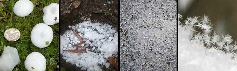
Sleet pellets, also known as ice pellets, are frozen raindrops that hit the ground.
"In a sleet situation the precipitation aloft when it is first generated will be snow," according to the National Weather Service.
"The snow falls through a layer that is a little above freezing and the snow partially melts. If the snow completely melts it will be more likely to reach the earth's surface as supercooled water instead of sleet. If the snow partially melts there will still be ice within the falling drop for water to freeze on when the drop falls into a subfreezing layer.
"The lowest layer of the troposphere will be below freezing in a sleet situation and deep enough to freeze drops completely. The lower boundary layer can be above freezing and sleet occurs if the sleet does not have time to melt before reaching the surface."
What is the difference between sleet pellets and hail?
Hail is dense precipitation ice that is at least 5 millimeters in diameter, according to the National Weather Service.
"Hail will commonly have soft ice and hard ice layers when it is sliced open."
Soft hail is more white and less dense because of air bubbles. Hard hail occurs when liquid water drops freeze on the outer edges of the hailstone, creating solid ice.
First round of storms arriving today in Florida
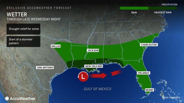
AccuWeather forecasters said the first sizable storm in a "rain train" that brought wet weather to central Texas will expand along the Gulf Coast into late Wednesday night.
An area from Houston to Panama City could get up to 2 inches of rain through late Wednesday night.
The National Weather Service in Tallahassee tweeted this morning that as the first wave moves through the area today, it is forecast to bring light to moderate rain, along with hazardous marine conditions for small craft.
More storms forecast for weekend
"The potential exists for another storm to pass through the same affected areas of the South Central and Southeastern states Friday into the weekend," said Meteorologist Brandon Buckingham.
Friday and Saturday could bring "locally damaging wind gusts and a couple of tornadoes," tweeted the National Weather Service Tallahassee.
Residents were advised locally heavy rain is possible, along with gale conditions over water, high surf and possible beach erosion.
The strongest cold fronts are forecast to arrive on Saturday and then again Tuesday, the National Weather Service Melbourne said.
New week could bring even more rain to Florida
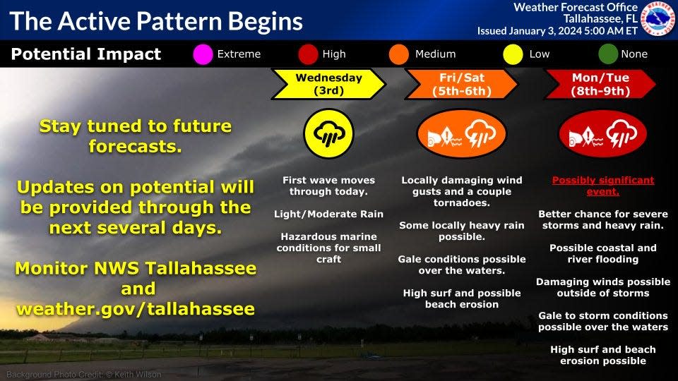
A "possibly significant event" is in the forecast for the Tallahassee area Jan. 8-9, the National Weather Service in Tallahassee warned this morning.
Conditions could bring:
Better chance for severe storms and heavy rain.
Damaging winds possible outside of storms.
Gale-to-storm conditions possible over water.
High surf and beach erosion possible.
Possible coastal and river flooding
Each passing storm has the potential to produce 1-2 inches of rain across a wide swath, with locally higher amounts possible.
There is the potential for one or more of these storms to produce locally severe thunderstorms across the South, in addition to heavy rainfall.
Weather radar and forecast for Pensacola

Follow National Weather Service Mobile on X, formerly known as Twitter
Wednesday: Showers. High near 53. East wind 10 to 15 mph, with gusts as high as 20 mph. Chance of precipitation is 100%. New precipitation amounts between a half and three quarters of an inch possible.
Wednesday night: A 20 percent chance of showers before 9pm. Mostly cloudy, with a low around 36. North wind 10 to 15 mph, with gusts as high as 25 mph.
Thursday: Sunny, with a high near 55. North wind around 10 mph.
Thursday night: Mostly clear, with a low around 42. North wind 5 to 10 mph becoming east after midnight.
Weather radar and forecast for Tallahassee
Follow the National Weather Service Tallahassee on X, formerly known as Twitter
Wednesday: Rain, mainly after 3 p.m. High near 54. North northeast wind around 5 mph. Chance of precipitation is 80%. New precipitation amounts of less than a tenth of an inch possible.
Wednesday night: Rain, mainly before 11 p.m. Low around 38. East northeast wind 5 to 10 mph becoming north after midnight. Chance of precipitation is 80%. New precipitation amounts between a tenth and quarter of an inch possible.
Thursday: Partly sunny, then gradually becoming sunny, with a high near 58. North wind around 10 mph.
Thursday night: Clear, with a low around 36. North wind around 5 mph.
Weather radar and forecast for Jacksonville

Follow the National Weather Service Jacksonville on X, formerly known as Twitter
Wednesday : Patchy fog before 9 a.m. Otherwise, mostly sunny, with a high near 62. Calm wind becoming southeast 5 to 7 mph in the afternoon.
Wednesday night: Showers likely before 11 p.m., then rain between 11 p.m. and 1 a.m., then showers likely after 1 a.m. Low around 44. North wind around 7 mph. Chance of precipitation is 80%. New precipitation amounts between a tenth and quarter of an inch possible.
Thursday: A 30 percent chance of showers before 7 a.m. Mostly cloudy through mid-morning, then gradual clearing, with a high near 60. North wind 7 to 11 mph, with gusts as high as 17 mph.
Thursday night: Clear, with a low around 43. Northeast wind 5 to 7 mph.
This article originally appeared on Treasure Coast Newspapers: Florida weather forecast: sleet pellets, cold fronts, possible tornado

