Cold storm bringing rounds of snow to Northwest


AccuWeather meteorologists are tracking a storm that will collide with a fresh outbreak of frigid air and set the stage for a round of snow and slippery travel along the Interstate 5 corridor in Oregon. Dangerous travel conditions can extend farther inland and southward, where snow may be measured in feet.
The region has endured a tumultuous week of heavy snowfall and difficult travel through the passes as multiple storms have moved into the Northwest. These storms have gone on to produce round after round of blizzard conditions, severe thunderstorms and flooding rainfall farther to the east across the United States.
"A frigid air mass sinking into the area will encounter the latest storm system moving in from the Pacific into Saturday night. This will allow for snow down to unusually low levels over much of the Northwest," AccuWeather Senior Meteorologist Heather Zehr said.
 |
On Thursday night, Seattle was cold and moist enough for a bit of snow to fall. There were a few reports of around a coating to 1.5 inches of snow to the east and north of the city.
"There will be too much dry air in place in the coldest areas over northern Washington and Idaho, so they will avoid any snow or ice with the latest storm," Zehr said. Despite a lack of winter precipitation, it will be cold in Seattle through the weekend, with highs 15-25 degrees Fahrenheit below the historical average in the upper 40s.
 |
Travel is likely to turn treacherous along the Interstate 5 corridor from Portland to just north of Medford, Oregon. The most significant icing impacts are expected to be centered over Salem, Corvallis and Eugene.
"In the Willamette Valley, the cold air will be trapped in place while warm air surges overhead. This is likely to lead to a longer period of freezing rain that will create hazardous travel. A potentially significant buildup of ice can cause tree damage and trigger power outages," Zehr said.
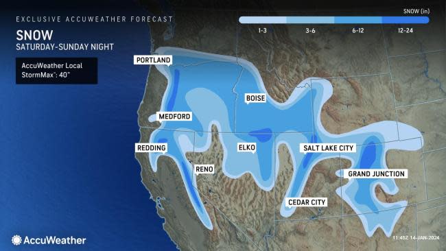
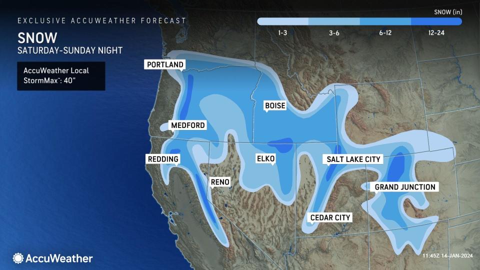
Precipitation is expected to take the form of snow for the duration of the storm from the Oregon Cascades and California's Sierra Nevada eastward into southern Idaho, northern Nevada and Utah. The highest snow totals on the order of feet are likely to occur in the mountains to the west and southwest of Bend, Oregon with the AccuWeather Local StormMax™ of 40 inches.
The storm track will promote accumulating snow even in the valley areas that are typically sheltered from sizable snowfall accumulations.
"Interior areas received the heaviest snow Saturday afternoon into Saturday night," Zehr said.
 |
Boise, Idaho, added to their impressive snowfall amounts this month. Typically, in January, the city receives 5.3 inches. As of Jan. 14, they have quadrupled that amount with 20.3 inches so far.
Farther southeast, Salt Lake City is running ahead of pace for snowfall this month, picking up 10.9 inches as of Jan. 14, compared to the month-to-date historical average of 4.8 inches.
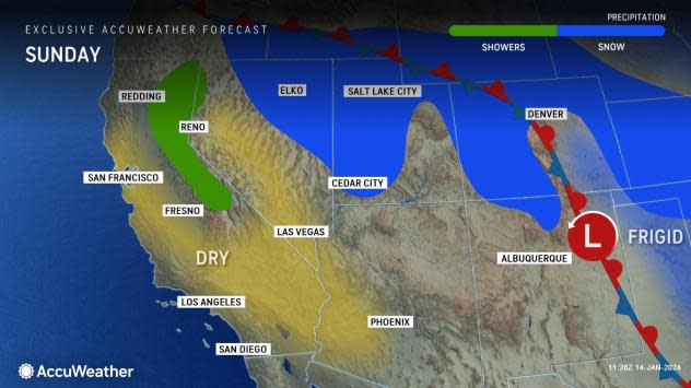
A quieter period of weather is expected to follow this winter onslaught into Monday as an area of high pressure builds in. However, the break could be short-lived as more storminess can arrive in the region from the Pacific toward the middle and end of the week. A storm that rolls in on Tuesday could bring a zone of ice or a wintry mix to the I-5 corridor from Portland to Seattle.
Meanwhile, the energy from the storm that will move into the Northwest early this weekend may produce snow and ice across the South and East next week.
Want next-level safety, ad-free? Unlock advanced, hyperlocal severe weather alerts when you subscribe to Premium+ on the AccuWeather app. AccuWeather Alerts™ are prompted by our expert meteorologists who monitor and analyze dangerous weather risks 24/7 to keep you and your family safer.
