Spy satellite photos reveal hundreds of long-lost Roman forts, challenging decades-old theory
- Oops!Something went wrong.Please try again later.
Sign up for CNN’s Wonder Theory science newsletter. Explore the universe with news on fascinating discoveries, scientific advancements and more.
Declassified photos captured by United States spy satellites launched during the Cold War have revealed an archaeological treasure trove: hundreds of previously unknown Roman-era forts, in what is now Iraq and Syria.
Many of those long-lost structures may be gone forever at this point, destroyed or damaged over recent decades due to agricultural expansion, urban development and war. Nevertheless, the discovery of the forts’ existence challenges a popular hypothesis established in the 1930s about the role of such fortifications along the ancient Roman Empire’s eastern border, researchers reported Wednesday in the journal Antiquity.
Based on the satellite views, the high number of forts and their widespread distribution hints that the forts may not have been erected to keep enemies out, as the decades-old theory suggested. Rather, the structures were likely built to ensure safe passage for caravans and travelers along routes that saw plenty of nonmilitary traffic. These forts, according to the study authors, were outposts and havens, not hostile barriers.
High-resolution images analyzed in the new study were taken during flyovers by multiple satellites belonging to two US military programs: the Corona Project (1960 to 1972) and Hexagon (1971 to 1986). Corona’s images were declassified in 1995, and Hexagon’s photos were released to the public in 2011.
Images from Hexagon and Corona are invaluable for archaeologists because they preserve snapshots of landscapes that have since undergone significant disruption, said lead study author Jesse Casana, an archaeologist and professor in the department of anthropology at Dartmouth College in New Hampshire.
“Agriculture and urbanization have destroyed a lot of archaeological sites and features to a shocking degree,” Casana told CNN. “This old imagery allows us to see things that are often either obscured or no longer extant today.”
Spy satellite photos vs. the Poidebard survey
Satellite images are especially helpful for searches across the northern part of the Fertile Crescent in the Middle East — from the eastern coast of the Mediterranean to western Iran — because of the area’s archaeological importance and high visibility of the ground in photos, Casana added.
The research team pored over the images for signs of Roman forts, which have a distinctive square shape and walls that usually measure about 164 to 262 feet (50 to 80 meters) long. The scientists began their search using reference maps from an aerial survey of the region conducted in the 1920s and 1930s by French archaeologist and Jesuit missionary Father Antoine Poidebard. That survey was among the first to photograph archaeological sites from the air, and in 1934 Poidebard reported finding 116 Roman forts.
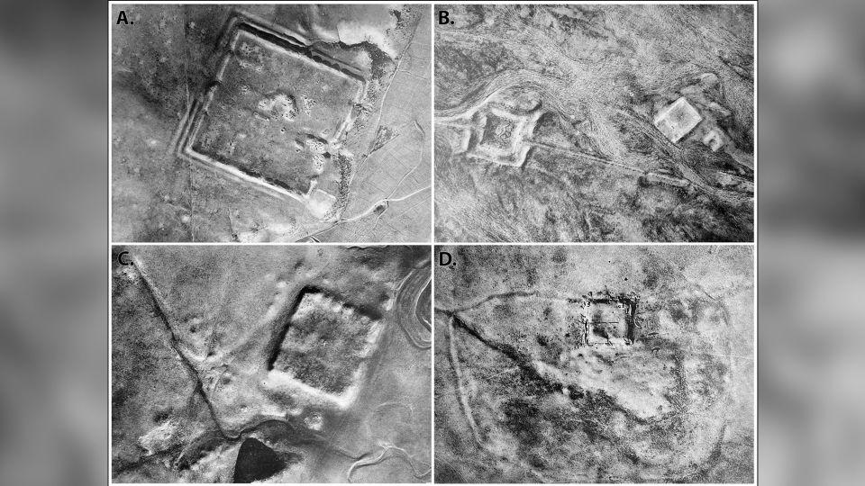
It was an unprecedented achievement. But nearly a century later, mapping Poidebard’s forts to satellite photos was challenging. Because his map wasn’t large-scale, it contained numerous spatial errors, Casana said. Poidebard also did not provide names or numbers for most of the forts he found, identifying them instead by their proximity to geologic features.
Those forts were aligned north to south along what was once the easternmost boundary of the Roman Empire, according to Poidebard. This arrangement, he claimed, was surely intended to guard against invaders from the east.
But Poidebard’s survey provided only a partial view of Rome’s ancient infrastructure, the researchers found. What he overlooked — and what the satellite photos revealed — was that the north-to-south line of 116 forts was actually only a narrow sliver of a cluster spreading from east to west and containing 396 fortified structures.
The forts spanned approximately 116,000 square miles (300,000 square kilometers), “extending from Mosul, on the Tigris River in Iraq, through Ninawa province, across the Khabur and the Balikh valleys, continuing to the semi-arid plains west of the Euphrates River, leading to western Syria and the Mediterranean,” according to the study.
Oases of safety for ancient Rome
When the archaeologists performed a second survey of an image subset, they found 106 more fortlike structures, hinting that further investigations will yield many more Roman forts. Based on excavations of other Roman sites in the region, the scientists estimated that the forts were built between the second and sixth centuries.
While Poidebard’s row of forts along the Roman Empire’s eastern front looked like a military fortification, this new evidence suggested that the forts collectively served a different purpose. Rather than presenting an impassable wall on a violent frontier, they provided oases of safety and order along well-traveled Roman roads.
Borders in this world “were places of dynamic cultural exchange and movement of goods and ideas,” not barriers, Casana said. And perhaps that perspective holds a lesson for the modern era, he added.
“Historically, as an archaeologist, I can say that there have been many attempts by ancient states to build walls across borders and it has been a universal failure,” Casana said. “If there’s any way that archaeology contributes to modern discourse, I would hope it is that building giant walls to keep people out is a bad plan.”
Mindy Weisberger is a science writer and media producer whose work has appeared in Live Science, Scientific American and How It Works magazine.
For more CNN news and newsletters create an account at CNN.com

