Colder than normal weather alert issued for Tri-Cities. Here’s the snow forecast
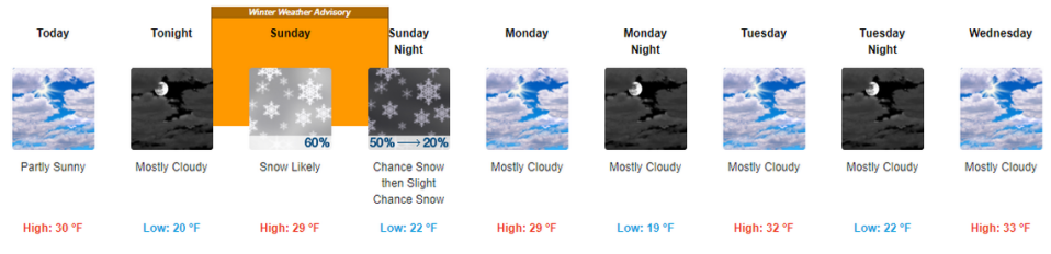
A winter weather advisory is issued for the Tri-Cities area starting at 4 a.m. Sunday and lasting until night.
Snow is likely Sunday across the Mid-Columbia, with enough snow possible in the Tri-Cities to cover the ground.
The National Weather Service forecast puts the chance of snow in the Tri-Cities at 60%, with an inch accumulation possible.
That’s the center of a range that includes the possibility of no snow accumulation to as much as 2 inches in the Tri-Cities.
Snow is most likely until 10 p.m. Sunday, decreasing to a 20% chance of snow later in the night. Any accumulation overnight should be less than half an inch, says the weather service.
The snow forecast for Sunday could be the last the Tri-Cities sees through the coming work week.
Cloudy skies are forecast Monday through Wednesday with just a slight chance of snow Thursday and Friday, according to the extended weather forecast.
Temperatures will continue to be colder than normal for early December in the Tri-Cities.
Highs are expected to gradually warm from 29 degrees on Sunday to 34 by Friday. Lows are expected to range from 19 degrees to 21.
That’s about 10 degrees below the normal highs and lows for the Tri-Cities in early December.


