Coldest temperatures of season expected in some Florida locations this weekend
Grab your jacket. Well, maybe not.
As residents across the Great Lakes and Northeast prepare for the sudden arrival of winter this weekend, Florida residents will do the same thing.
It'll probably take a lot less time to prepare here, but cooler temperatures will be a welcome respite from record highs the Sunshine State has seen for the past several months.
The National Weather Service in Melbourne may have summed it up best in its tweet:
"If you've been waiting for a cool down across central Florida, you're in luck! Cooler temperatures will arrive this weekend behind a cold front with many locations forecast to drop into the 60s for low temperatures. 😎"
The National Weather Service Tallahassee warned residents, "A series of cold fronts will move through this weekend bringing us our coldest morning temps of the fall season so far."
So how cold will it really get around the Sunshine State this weekend?
Tallahassee and Panama City could see temperatures drop to 53 Sunday morning. By Monday morning, Tallahassee is looking at a low of 48.
Across most of the peninsula, temperatures are expected to drop into the low to high 60s for a day or two. Farther south, Naples and West Palm Beach will see lows in the low to mid 70s.
That's quite a difference from what our northern neighbors will get hit with.
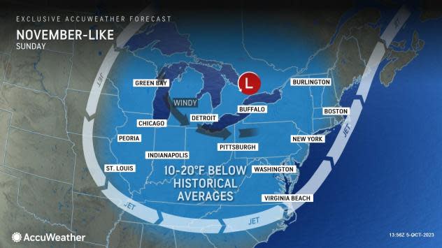
"The coldest air of the season yet will arrive across the Upper Midwest and Northeast from this weekend to early next week," warned AccuWeather meteorologists. Much cooler temperatures could dip into the Carolinas.
Temperatures of 10 to 20 degrees above the seasonal average will be replaced with temperatures of 10 to 20 degrees below average in a matter of a few days.
Weather watches and warnings issued across Florida
Weather radar for Pensacola

Follow National Weather Service Mobile on Twitter
Pensacola weather forecast
Rain chances will be a bit elevated today as a cold front sweeps across the area. High temperatures will climb into the low to mid 80s this afternoon. #mobwx pic.twitter.com/jlUxag72bv
— NWS Mobile (@NWSMobile) October 6, 2023
A red flag warning is in effect from 11 a.m. to 7 p.m. Saturday. A red flag warning means critical fire weather conditions are either occurring now, or will shortly. A combination of strong winds, low relative humidity, and warm temperatures can contribute to extreme fire behavior.
Friday: High 86; low 67. Rain chances 30%.
Saturday: High 81; low 55.
Sunday: High 75; low 55.
Columbus Day: High 78; low 60.
What is a red flag warning? Pensacola Red flag warning issued but not the kind you think. What to know about fire warning
Weather radar for Tallahassee
Follow the National Weather Service Tallahassee on Twitter
Tallahassee weather forecast
A series of cold fronts will move through this weekend bringing us our coldest morning temps of the fall season so far. Here are some morning temps you could see. Additionally, with dry and breezy conditions on Saturday, fire weather concerns will increase. #FLwx #ALwx #GAwx pic.twitter.com/KsMWDf0Qit
— NWS Tallahassee (@NWSTallahassee) October 5, 2023
A fire weather watch is in effect from noon Saturday through 8 p.m. Saturday. A fire weather watch means that critical fire weather conditions are forecast to occur, including gusty winds and low humidity.
Friday: High 86; low 68.
Saturday: High 82; low 52
Sunday: High 74; low 46
Columbus Day: High 79; low 53
Weather radar and forecast for Jacksonville
Follow the National Weather Service Jacksonville on Twitter
Friday: High 85; low 69
Saturday: High 86; low 58
Sunday: High 76; low 53
Columbus Day: High 80; low 56
Weather radar for Daytona Beach

Follow the National Weather Service Melbourne on Twitter
Weather forecast for Daytona Beach
Oct 4 | If you've been waiting for a cool down across central Florida, you're in luck! Cooler temperatures will arrive this weekend behind a cold front with many locations forecast to drop into the 60s for low temperatures.😎 pic.twitter.com/C8Ergj1lLX
— NWS Melbourne (@NWSMelbourne) October 5, 2023
Boating conditions may become poor again over the Gulf Stream Saturday night into Sunday as northwest to north winds briefly increase behind a cold front which will push through the local Atlantic waters.
Friday: High 83; low 69
Saturday: High 86; low 65
Sunday: High 77; low 62
Columbus Day: High 78; low 64
Cooler temperatures coming: Not quite sweater weather, but cooler temps on the way for Volusia, Flagler
Weather radar for Melbourne
Follow the National Weather Service Melbourne on Twitter
Weather forecast for Melbourne
Oct 4 | If you've been waiting for a cool down across central Florida, you're in luck! Cooler temperatures will arrive this weekend behind a cold front with many locations forecast to drop into the 60s for low temperatures.😎 pic.twitter.com/C8Ergj1lLX
— NWS Melbourne (@NWSMelbourne) October 5, 2023
Boating conditions may become poor again over the Gulf Stream Saturday night into Sunday as northwest to north winds briefly increase behind a cold front which will push through the local Atlantic waters.
Friday: High 87; low 72
Saturday: High 87; low 71
Sunday: High 82; low 69
Columbus Day: High 82; low 70
Weather radar for Port St. Lucie
Follow the National Weather Service Melbourne on Twitter
Weather forecast for Port St. Lucie
Oct 4 | If you've been waiting for a cool down across central Florida, you're in luck! Cooler temperatures will arrive this weekend behind a cold front with many locations forecast to drop into the 60s for low temperatures.😎 pic.twitter.com/C8Ergj1lLX
— NWS Melbourne (@NWSMelbourne) October 5, 2023
Boating conditions may become poor again over the Gulf Stream Saturday night into Sunday as northwest to north winds briefly increase behind a cold front which will push through the local Atlantic waters.
Friday: High 88; low 71
Saturday: High 88; low 70
Sunday: High 84; low 68
Columbus Day: High 83; low 70
Weather radar and forecast for West Palm Beach

Follow the National Weather Service Miami on Twitter
Friday: High 85; low 77
Saturday: High 85; low 76
Sunday: High 83; low 76
Columbus Day: High 82; low 76
Weather radar and forecast for Naples
Follow the National Weather Service Miami on Twitter
Friday: High 89; low 74
Saturday: High 89; low 73
Sunday: High 87; low 70
Columbus Day: High 85; low 71
Weather radar for Fort Myers

Follow the National Weather Service Tampa Bay on Twitter
Weather forecast for Fort Myers
🌡️ A few of our #FLwx climate sites experienced record-tying heat today, with highs in the lower 90s
🍂 Expect a couple more days of near-record warmth before a weekend cold front ushers in a hint of Autumn, at least by Florida standards pic.twitter.com/ojxF2jtyRR— NWS Tampa Bay (@NWSTampaBay) October 5, 2023
Friday: High 89; low 74
Saturday: High 89; low 72
Sunday: High 84; low 68
Columbus Day: High 82; low 70
Cool change for Fort Myers: Just how cool will it get this weekend? NWS has the answers
Weather radar for Sarasota
Follow the National Weather Service Tampa Bay on Twitter
Weather forecast for Sarasota
🌡️ A few of our #FLwx climate sites experienced record-tying heat today, with highs in the lower 90s
🍂 Expect a couple more days of near-record warmth before a weekend cold front ushers in a hint of Autumn, at least by Florida standards pic.twitter.com/ojxF2jtyRR— NWS Tampa Bay (@NWSTampaBay) October 5, 2023
Friday: High 90; low 74
Saturday: High 89; low 70
Sunday: High 80; low 65
Columbus Day: High 83; low 67
This article originally appeared on Treasure Coast Newspapers: Florida weather forecast, radar. Cold front coming. See expected lows
