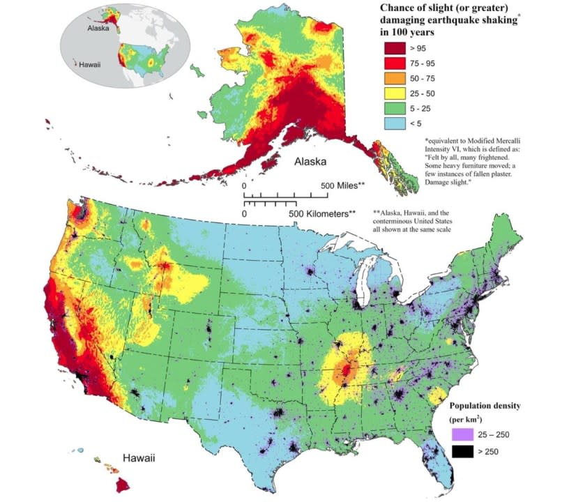
Color-coded map shows where ‘damaging’ earthquakes are most likely to occur

SAN DIEGO (KSWB) — Earthquakes can’t be predicted but a new scientific assessment by the United States Geological Survey (USGS) has revealed areas where scientists predict “damaging” earthquakes are most likely to occur.
According to the latest USGS National Seismic Hazard Model (NSHM), which was released in December 2023, 75% of the U.S. could experience damaging seismic shaking in the next 100 years.
The new model was determined by a USGS-led team of more than 50 scientists and engineers using new science on seismicity, fault ruptures, ground motions and probabilistic techniques.
How the drying Salton Sea could be fending off California’s next ‘big one’
The NSHM update can be used as a tool for engineers to help figure out how earthquakes may affect “the most vulnerable communities,” USGS explained. By showing likely earthquake locations and how much shaking they might produce, mitigation efforts can be put into place.
“This was a massive, multi-year collaborative effort between federal, state and local governments and the private sector,” said Mark Petersen, USGS geophysicist and lead author of the study. “The new seismic hazard model represents a touchstone achievement for enhancing public safety.”
As part of the NSHM findings, researchers created a color-coded map that pinpoints areas in the country that are most likely to experience damaging shaking based on insights from their seismic studies. It may comes as no surprise that much of California is in the dark red zone, which represents the highest hazard risk.
California’s north coast has a long history of strong earthquakes
Also covered in dark red is a great portion of Alaska and Hawaii.
Which California landmarks are at risk from a massive earthquake?
“Yes, I think it is safe to say that California has the most risk from damaging earthquake shaking,” said Allison Shumway, a research geophysicist with the USGS who worked on this study. “There are other areas on the map that are dark red, indicating a high chance of shaking, but the risk is lower as there are less people and infrastructure in those areas.”
According to USGS, nearly 500 additional faults that could produce a damaging earthquake were discovered during this assessment. The experts have said this showcases the “evolving landscape of earthquake research.”
Are most of these news faults in California?
“Actually, most of the additional faults included in this update are located in areas of the Western U.S. outside of California — in the Intermountain West, Pacific Northwest and Alaska,” said Shumway. “There was only a 2% increase in the number of included faults in California in this update vs. the previous update in 2018.”
California’s largest earthquakes of the 21st century
When considering widespread hazards, USGS noted 37 U.S. states have experienced earthquakes exceeding magnitude 5 during the last 200 years. Experts said this highlights a long history of seismic activity across this country.
“Earthquakes are difficult to forecast but we’ve made great strides with this new model,” said Petersen. “The update includes more faults, better-characterized land surfaces, and computational advancements in modeling that provide the most detailed view ever of the earthquake risks we face.”
Though it’s uncertain when the next “big one” will strike, investigating faults and past quakes is helping scientists better assess the likelihood of future shaking across the country.
For the latest news, weather, sports, and streaming video, head to FOX 5 San Diego.


