Colorado weather alert: What to expect for snow totals, travel impacts and more
Yes, there is a strong winter storm brewing for Colorado, but there is a large line of demarcation of forecast snowfall totals and travel impacts.
Here is the storm's breakdown, including what's expected in Fort Collins:
Timing of the snow and wind
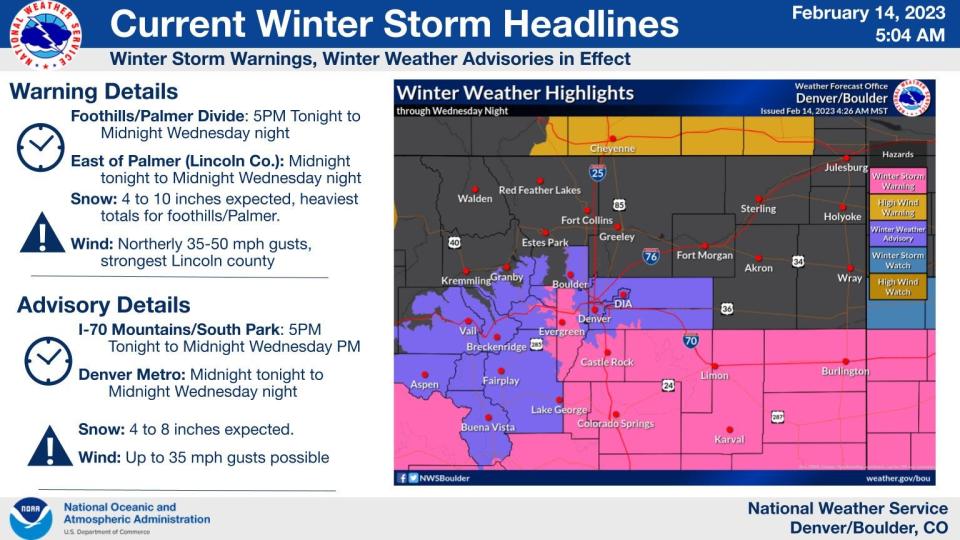
11 p.m. Tuesday, Feb. 14, through 5 a.m. Thursday, Feb. 16: Winter weather warning for Denver south to New Mexico border.
5 p.m. Tuesday through noon Thursday: Winter weather advisory for Boulder-Denver area and west.
5 p.m. Tuesday: Snowfall begins along Interstate 70 Mountains, South Park, central-southern foothills, Palmer Divide and the southern half of the state.
Midnight Tuesday through early Thursday morning: Snowfall expected in the Denver metro area and southern half of the state, when heaviest snow and windy conditions take place.
Winter storm's impacts on Fort Collins and Northern Colorado
Little to none as the low pressure is tracking too far south.
Fort Collins is forecast for 1-2 inches of snow and the Eastern Plains, where blowing snow could make travel hazardous, is forecast for 1 to 5 inches.
With this track, the upslope conditions, which produce larger amounts of snow, will only reach north to around Longmont.
There are no winter weather advisories, watches or warnings for Northern Colorado.
Expect these major roads to be impacted by the storm
Interstate 25 from Denver south to the New Mexico border
I-70 southeast of Denver to the Kansas border and west of Denver
U.S. Highway 24 east of Colorado Springs
U.S. Highway 287 south of Limon
U.S. Highway 160 west of Walsenburg and east of Trinidad
U.S. Highway 350 northeast of Trinidad
For road conditions, visit cotrips.org or call 511
National Weather Service forecast snowfall totals for around Colorado
Fort Collins: 1-2 inches
Boulder: 2-6 inches
Estes Park: 1-4 inches
Denver: 4-7 inches
Fort Morgan: 1-3 inches
Eisenhower Tunnel: 5 to 10 inches
Conifer: 5-11 inches
Winter Park : 5-10 inches
Limon: 4-8 inches
Castle Rock: 5-9 inches
Colorado Springs: 3-6 inches
Pueblo: 4-7 inches
La Junta: 6-10 inches
Trinidad: 7-12 inches
Wolf Creek Pass: 20-29 inches
Winter Weather still on track to arrive later today. Most travel impacts will come after the evening rush tonight, but be prepared for slick/hazardous travel by Wednesday AM! Check latest road conditions at https://t.co/uoUwxQXFoP or @ColoradoDOT #cowx pic.twitter.com/1pp2ZDz4sT
— NWS Boulder (@NWSBoulder) February 14, 2023
This article originally appeared on Fort Collins Coloradoan: Forecast Colorado snow totals, travel impacts of latest storm

