Colorado weather alert: 6-11 inches of snow possible Tuesday into Wednesday
Fort Collins and the entire northeast quarter of the state is under a winter weather warning with impressive snow totals and strong wind expected to blast the area Tuesday into Wednesday.
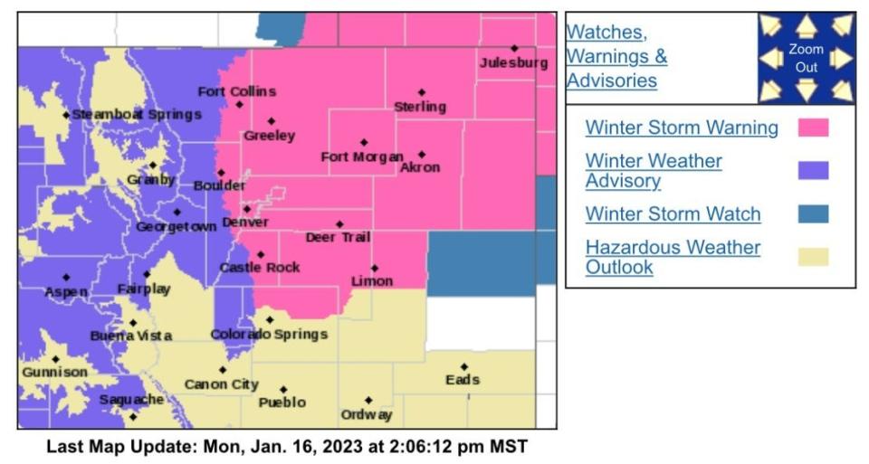
Here's what we know as the storm approaches Colorado, according to the National Weather Service:
Winter storm warning includes eastern one-third of Larimer County; what does it mean?
The National Weather Service has issued a winter storm warning from 5 p.m. Tuesday through 5 p.m. Wednesday evening from the Colorado/Wyoming border line south to Castle Rock and east to the Nebraska/Kansas borders. The area could see 6 to 11 inches of snow with up to 35 mph wind gusts.
A warning means there is a strong likelihood for significant and hazardous winter weather.
Timing of storm and travel impacts
Tuesday afternoon: Snow develops in the mountains and spreads onto the Eastern Plains.
Tuesday night: Snow intensifies, with locally heavy bands developing on the Eastern Plains.
Wednesday: Snow continues, gradually ending west to east through the day.
If heavier snow develops earlier on Tuesday, the evening commute could be impacted. Wednesday morning's commute is expected to be impacted.
Interstate 76 runs directly through the higher forecast snowfall area and is expected to see difficult travel conditions. The same is possible for U.S. Highway 34 from Greeley east to the Nebraska state line. The eastern section of Colorado Highway 14, Interstate 70 and Interstate 80 through southern Wyoming from Cheyenne east are also expected to see impacts.
Interstate 25 could see some impact from Fort Collins south to Castle Rock.
Fort Collins breakdown of when snow arrives, falls heaviest
11 a.m. to 5 p.m. Tuesday: 30% chance of snow. Less than a half-inch expected. Wind 5-10 mph, gusting to 16 mph
5 p.m. Tuesday to 5 a.m. Wednesday: 80% chance of snow. 3-5 inches of snow expected. Wind 7-9 mph, gusting to 15 mph
5-11 a.m. Wednesday: 60% chance of snow. Wind 11-14 mph, gusting to 22 mph
11 a.m. to 4 p.m. Wednesday: 30% chance of snow
A look at probable snowfall totals; Eastern Plains wears the bullseye
Here are the probabilistic snowfall forecast totals predicted by NWS as of Monday:
Fort Collins: 6 inches expected: 98% chance 1 inch or more, 89% chance 2 inches or more, 61% chance 4 inches or more, 40% chance 6 inches or more and 19% chance 8 inches or more
Greeley: 7 inches expected: 95% chance 2 inches or more, 71% chance 4 inches or more, 49% chance 6 inches or more and 26% chance 8 inches or more
DIA: 8 inches expected. 99% chance 2 inches or more, 80% chance 4 inches or more, 61% chance 6 inches or more and 40% chance 8 inches or more
Downtown Denver: 7 inches expected. 97% chance 2 inches or more, 76% chance 4 inches or more, 57% chance 6 inches or more and 37% chance 8 inches or more
Boulder: 5 inches expected. 98% chance 1 inch or more, 83% chance 2 inches or more, 54% chance 4 inches or more, 32% chance 6 inches or more and 4% chance 8 inches or more
Sterling: 8 inches expected. 97% chance 2 inches or more, 79% chance 4 inches or more, 62% chance 6 inches or more, 44% chance 8 inches or more and 5% chance 12 inches or more
Fort Morgan: 8 inches expected. 97% chance 2 inches or more, 77% chance 4 inches or more, 59% chance 6 inches or more, 39% chance 8 inches or more and 5% chance 12 inches or more
Holyoke: 10 inches expected. 92% chance 4 inches or more, 74% chance 6 inches or more, 60% chance 8 inches or more and 26% chance 12 inches or more
Castle Rock: 7 inches expected. 96% chance 2 inches or more, 76% chance 4 inches or more, 58% chance 6 inches or more and 29% chance 8 inches or more
Winter Park: 8 inches expected. 84% chance 4 inches or more, 52% chance 6 inches or more and 15% chance 8 inches or more
Walden: 2 inches expected. 78% chance 1 inch or more, 53% chance 2 inches or more and 2% chance 6 inches or more
Breckenridge: 4 inches expected. 90% chance 2 inches or more, 46% chance 4 inches or more and 3% chance 6 inches or more
Vail Pass: 8 inches expected. 92% chance 4 inches or more, 61% chance 6 inches or more and 30% chance 8 inches or more
Durango: 8 inches expected. 85% chance 6 inches or more, 66% chance 8 inches or more and 28% chance 12 inches or more
This article originally appeared on Fort Collins Coloradoan: Fort Collins could see significant snow. How much can we expect?

