Colossal storm threatens chaotic holiday travel across Ontario
A ferocious storm moving over the Great Lakes will lead to chaotic travel for the long holiday weekend across Ontario.
Heavy snowfall, potentially damaging winds, blizzard conditions, and a flash freeze are all hazards from this long-duration event.
Beware the potential for extensive power outages, road and business closures, and flight cancellations and delays. School boards across the Greater Toronto Area (GTA) and National Capital Region announced some school closures Friday ahead of the storm.
Winter storm warnings cover almost all of southern and eastern Ontario as we head into the main event on Friday. Blizzard warnings are in effect for much of the Huron shores, as well as a portion of the Niagara Peninsula.
RELATED: Holiday havoc: Vast, 3,000-km-sized storm puts travel plans in peril
Thursday night: Conditions deteriorate
Conditions will steadily deteriorate across the province overnight Thursday as the centre of this powerful low-pressure system moves into the heart of the Great Lakes region.
Northern and northeastern Ontario will see snowfall increase in coverage and intensity heading into the nighttime hours on Thursday.
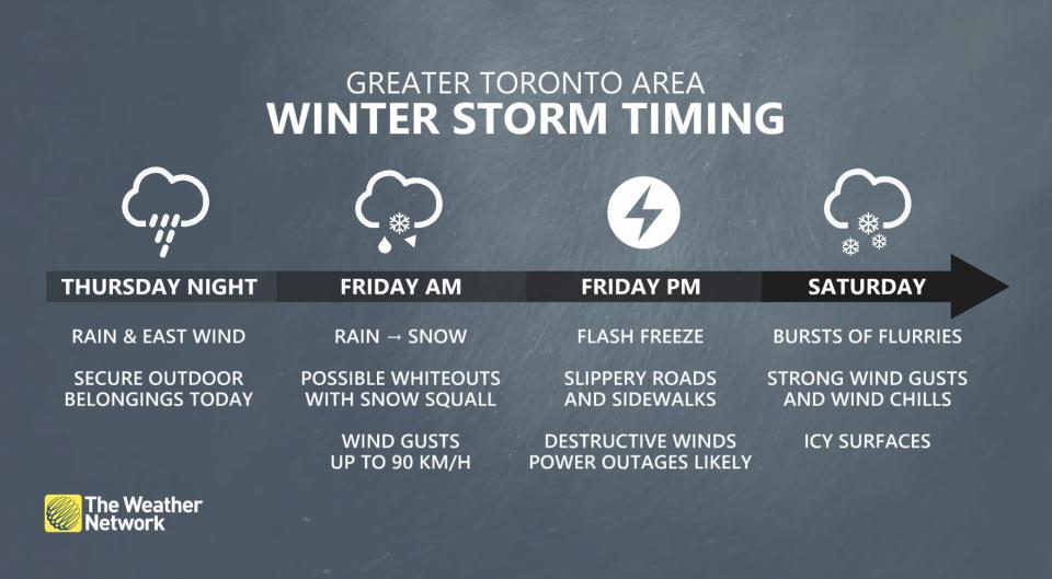
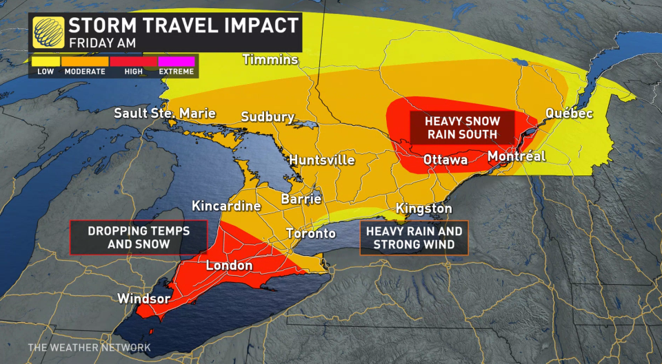
Southern Ontario will see rain increase across the region into Thursday night. Temperatures in the lower single digits should keep precipitation mostly rain for southern Ontario through the overnight hours.
Conditions overnight will be much trickier toward Ottawa, however, where colder temperatures are already locked in place.
This batch of colder air across the National Capital Region will allow for a period of heavy snowfall during the wee morning hours Friday. Ottawa could see 10-15 cm of snow before precipitation changes over to rain Friday morning, potentially snarling the region’s commute.
Friday: Threat for a flash freeze
WATCH: What is a flash freeze, and why is it so dangerous?
The weather you wake up to on Friday will feel like a completely different universe compared to the conditions you’ll endure by the middle of the afternoon.
Friday’s high temperature will occur early in the morning as commuters and travelers start the day with readings in the lower single digits. That won’t last long, though, as cold air wrapping around the low sends temperatures plummeting.
Readings will rapidly fall below freezing as the cold front roars over the region, allowing wet surfaces to ice over and become slick in a hurry.
A flash freeze is possible, posing a significant threat to the safety of motorists caught on the roads during and after the temperature drop.
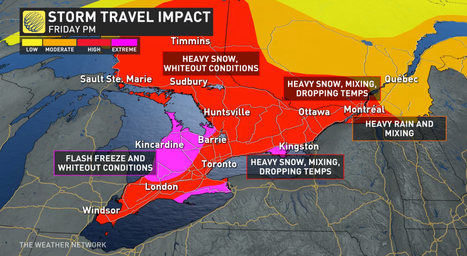
For the Greater Toronto Area (GTA) and southern Ontario, rain will transition to snow as temperatures fall through late morning, lunchtime, and beyond.
While the GTA won’t have to deal with major snow accumulations, the number of folks traveling to areas dealing with dangerous conditions makes it critical to be aware of what’s happening throughout the region.
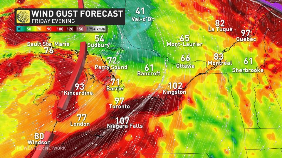
Those frigid temperatures will blow into Ontario on powerful winds that could lead to damage and power outages across the province.
Wind gusts will intensify throughout the day Friday as this powerful and dynamic system exerts its influence on the region. Lakeshore communities along Huron, Erie, and Ontario could see gusts exceed 90 km/h, with widespread gusts of 70-80+ km/h across the rest of southern Ontario.
In addition to the risk for power outages and damage, these intense winds could lead to blizzard conditions and whiteouts across areas dealing with snowfall.
Visibility can change rapidly during high winds and heavy snowfall. This is the kind of setup that can leave travelers stranded on the roads—no small threat when it’s going to be this cold and windy.
Powerful southwesterly winds across the lakes will also lead to large waves, as well as a risk for ice shoves and ice buildup along the shoreline.
Saturday (Christmas Eve): Howling winds and intense snow squalls
Howling winds will continue across Ontario through Saturday, giving rise to intense snow squalls across the traditional snowbelts.
Intense lake-enhanced snow squalls are likely off Lake Huron, Georgian Bay, and Lake Erie. Road closures are likely as heavy snowfall combines with powerful winds up to 100 km/h to lead to widespread whiteout conditions.
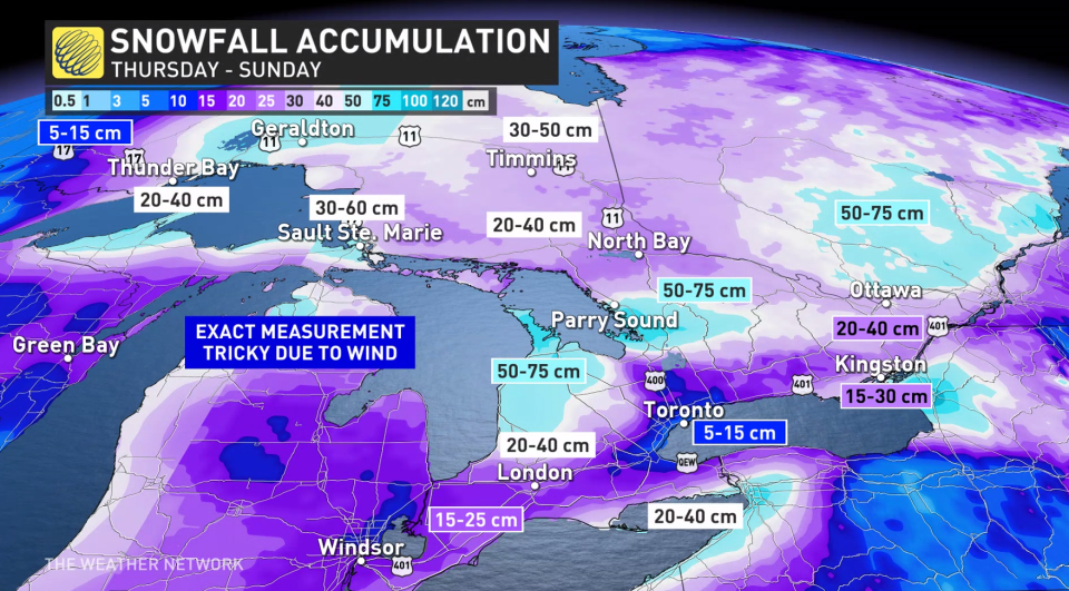
Regions caught beneath these snow squalls could see 50-75cm of snow by the end of the weekend. Exact measurements will be tricky due snow blowing and drifting in the high winds.

Sunday (Christmas Day): Conditions improve as the system moves east
Christmas Day itself is looking much better across the bulk of Ontario’s population centres as the storm lifts north and east out of the province.
Snow squalls will remain a threat for the snowbelts and some communities near Lakes Erie and Ontario. This lake-effect snow could meander and push through southern Ontario at times through the day Sunday.
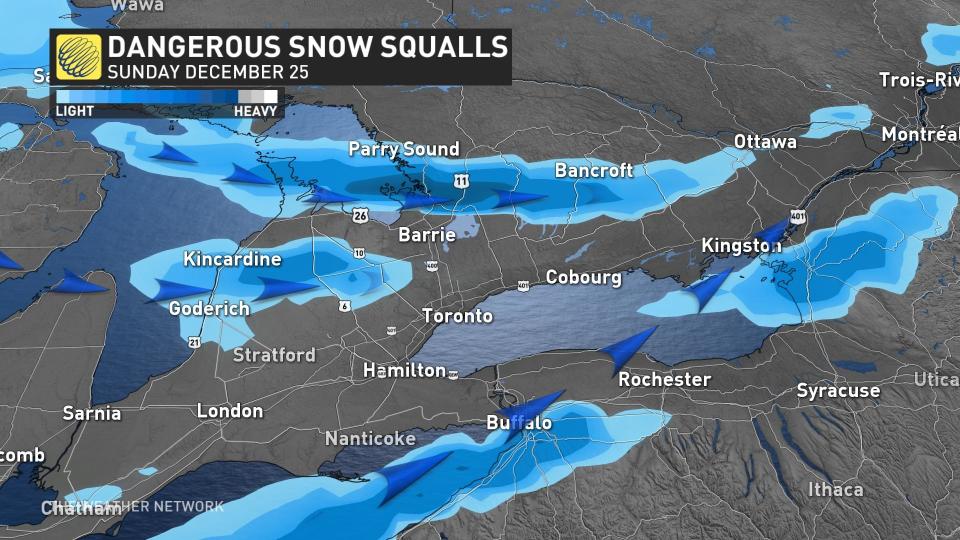
Check the forecast if you plan to travel on Christmas Day to see if there is any chance of encountering snow squalls on your route. The squalls will continue through the day, slowly winding down into Boxing Day on Monday.
WATCH: Your questions about holiday storm answered by our meteorologists
Check back for the latest on the forecast across southern Ontario.
ICYMI: Our Chief Meteorologist @ChrisScottWx along with meteorologists @ThatMetGirl @matt_grinter and weather expert @KMacTWN answer your questions about the incoming #ONStorm #QCStorm 🎙❄ https://t.co/nzsF0L6jeo
ICYMI: Our Chief Meteorologist The Weather Network on Twitter: "ICYMI: Our Chief Meteorologist @ChrisScottWx along with meteorologists @ThatMetGirl @matt_grinter and weather expert @KMacTWN answer your questions about the incoming #ONStorm #QCStorm 🎙❄ https://t.co/nzsF0L6jeo / Twitter" along with meteorologists The Weather Network on Twitter: "ICYMI: Our Chief Meteorologist @ChrisScottWx along with meteorologists @ThatMetGirl @matt_grinter and weather expert @KMacTWN answer your questions about the incoming #ONStorm #QCStorm 🎙❄ https://t.co/nzsF0L6jeo / Twitter" The Weather Network on Twitter: "ICYMI: Our Chief Meteorologist @ChrisScottWx along with meteorologists @ThatMetGirl @matt_grinter and weather expert @KMacTWN answer your questions about the incoming #ONStorm #QCStorm 🎙❄ https://t.co/nzsF0L6jeo / Twitter" and weather expert The Weather Network on Twitter: "ICYMI: Our Chief Meteorologist @ChrisScottWx along with meteorologists @ThatMetGirl @matt_grinter and weather expert @KMacTWN answer your questions about the incoming #ONStorm #QCStorm 🎙❄ https://t.co/nzsF0L6jeo / Twitter" answer your questions about the incoming The Weather Network on Twitter: "ICYMI: Our Chief Meteorologist @ChrisScottWx along with meteorologists @ThatMetGirl @matt_grinter and weather expert @KMacTWN answer your questions about the incoming #ONStorm #QCStorm 🎙❄ https://t.co/nzsF0L6jeo / Twitter" The Weather Network on Twitter: "ICYMI: Our Chief Meteorologist @ChrisScottWx along with meteorologists @ThatMetGirl @matt_grinter and weather expert @KMacTWN answer your questions about the incoming #ONStorm #QCStorm 🎙❄ https://t.co/nzsF0L6jeo / Twitter" 🎙❄ The Weather Network on Twitter: "ICYMI: Our Chief Meteorologist @ChrisScottWx along with meteorologists @ThatMetGirl @matt_grinter and weather expert @KMacTWN answer your questions about the incoming #ONStorm #QCStorm 🎙❄ https://t.co/nzsF0L6jeo / Twitter"
— The Weather Network (@weathernetwork) The Weather Network on Twitter: "ICYMI: Our Chief Meteorologist @ChrisScottWx along with meteorologists @ThatMetGirl @matt_grinter and weather expert @KMacTWN answer your questions about the incoming #ONStorm #QCStorm 🎙❄ https://t.co/nzsF0L6jeo / Twitter"
—
