Coming in spring 2023: New recreation area on former YMCA camp in Smithfield | Walking RI
SMITHFIELD — For decades, the Sprague Upper Reservoir was the centerpiece of the old YMCA Camp Shepard, an isolated, wooded retreat where boys and girls swam, camped, fished, hiked and learned about the outdoors.
The camp closed in 2008 and has been vacant ever since. It is no longer open to the public.
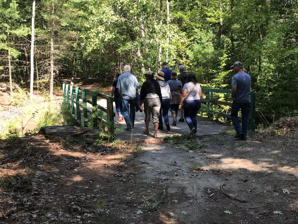
But in October 2020, the Town of Smithfield acquired the property for $1.225 million. Recently, town residents were invited to take guided tours on the land and offer suggestions for its best public use. The decisions made now will affect people for generations.
Walking RI: Hike through unique Ice Age terrain at Dr. John Champlin Glacier Park
Walking RI: Up for a hiking challenge? Tackle this section of the North South Trail in Exeter
I accompanied some residents last month on a walk through the 114-acre property. One common theme I heard from the walkers was an interest in creating a woodland experience to get their children and grandchildren off the couch and away from their cellphones and electronic games for some fresh air in the woods. Some suggested the property could one day include a zipline or climbing wall.
There have been other proposals, too.
Some suggested a small housing development on a slice of the land to recoup some of the purchase price. Another resident’s petition drive for a proposed Frisbee golf course garnered 1,400 signatures.
Walking RI: What's missing from Tiverton's Basket Swamp? A key tree for Native peoples
Walking RI: Hike along the Narrow River at former Girl Scout camp in North Kingstown
Those ideas, for now, are dead, according to Town Manager Randy Rossi, who said in an interview that the land will be preserved for passive recreation. More specific plans should be decided in a year or so, after a subcommittee studying the land collects suggestions and makes recommendations. The preserve will reopen to the public next spring, Rossi said.
During the planning, town leaders shouldn’t forget the area’s history, because the land can be a unique outdoor classroom, especially for youngsters.
Why is Camp Shephard closed to the public until spring?
Our group set out to explore the camp by walking down a dirt road that opens through a gate between two stone pillars off Colwell Road, where the town has posted no-trespassing and no-parking signs. Rossi said the land is off-limits because much of the rugged terrain has not been mapped and there are some dangerous spots that emergency responders would have a hard time reaching if there were an accident.
Our guide, Bill, grew up nearby and told stories about riding bikes with his friends to the reservoir to swim away the afternoon.
More: Fall bird migration is in full swing in RI. Here's where to go to enjoy the show.
Walking RI: Hike the 'Big Hill' in Cumberland, where skiing was once a favorite winter pastime
On the right, the road passes a ballfield with a backstop, a cracked asphalt basketball court (with no poles or baskets) and a wooden, open-windowed building that has seen better days. One walker suggested the area could be used for parking.
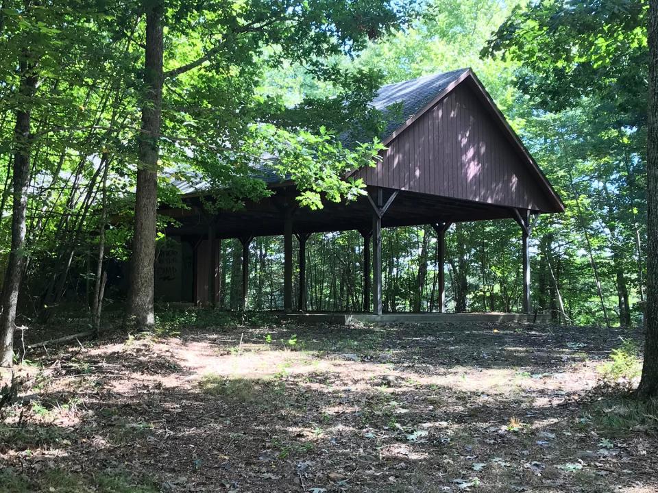
In a hundred yards, the road split and we went right and downhill. On a rise on the left is an old, open-sided, roofed pavilion with a cement floor. Graffiti has been spray-painted on what once was a stage, but overall it looked to be in pretty good shape.
On an adjoining hill, however, a log cabin-style building is badly deteriorated.
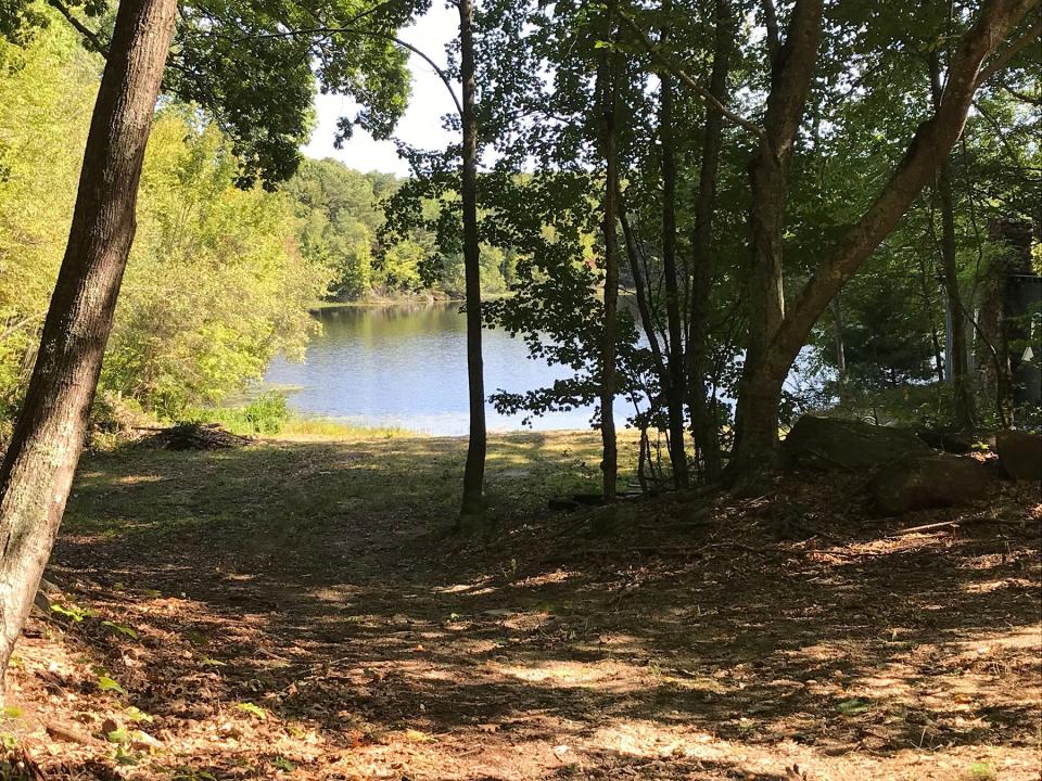
To the right of the cabin and downhill is a natural amphitheater with broken wooden benches, and to the right of that is the first glimpse of the reservoir. There’s a wide opening and a short, tree-lined walk to a grassy beach with some litter, a decaying building, a spooled swimming rope line and several damaged boating docks.
Walking RI: Discover a hidden gem of forest, ponds and wetlands in Little Compton
Walking RI: Spectacular bay views and Colonial and tribal history at Mount Hope Farm
The walkers suggested it would be a good place to store kayaks and canoes and to go swimming. But there seemed to be little interest in creating a special beach area such as the ones at Georgiaville Pond or Lincoln Woods.
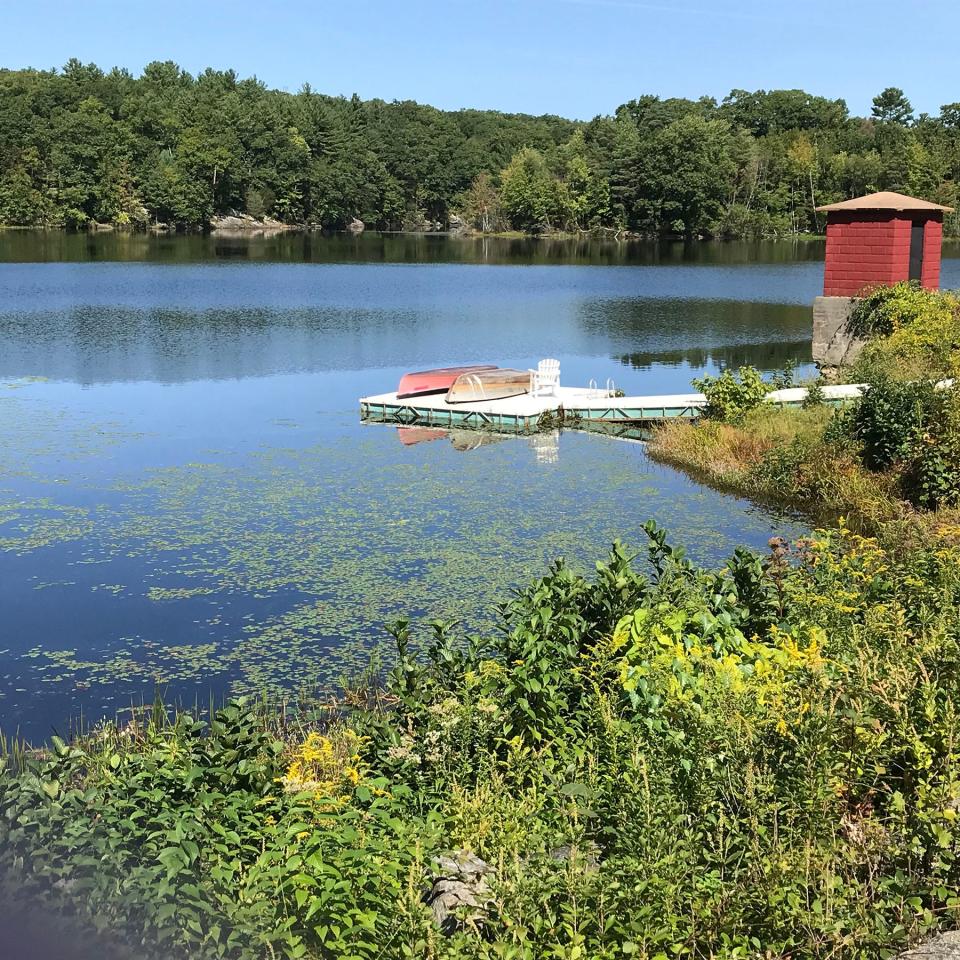
The view across the reservoir includes several coves, ledges, banks covered with trees and an earthen dam with a small, square gatehouse.
Former Brown University property became summer playground for YMCA campers
Brown University once owned the property and sold it for $1 in the 1960s to the Greater Providence YMCA, which built Camp Shepard in 1970.
Over the years, kids spent summers there learning to swim, row a boat, shoot a bow and arrow and camp overnight. The camp welcomed youngsters from the cities, and volunteers arrived from banks, insurance companies and nonprofits to make repairs and clear land. The Rhode Island National Guard once trained there and built some of the roads.
When the YMCA decided during the COVID crisis to sell some of its assets, the Town of Smithfield stepped up and bought the property and began its planning.
Walking RI: Discover why hikers and anglers love the 'wild and scenic' Beaver River
More: Want to practice some rock climbing? Head to Connors Farm in Smithfield
After stopping to survey the beach, our group continued down the gravel road and passed a red cement block garage, a storage shed and an asphalt lot that may have been used to store picnic tables, vehicles and camp equipment.
On the right, the land drops off into a swampy area before rising up a slope. Several small streams carry runoff from the hillside through culverts under the road and eventually to the reservoir.
The road then bends in a half circle under pine trees, with a stone wall flanking the path on the right, indicating this was once farmland. Houses, private property and several operating farms surround the camp. Town officials said the camp connects to conservation easements, land trust preserves and open land to form 450 acres of protected property.
The road runs up a small hill and turns east before passing a large house on the right and then emerging at the start of a 20-foot-high earthen dam that stretches about 250 feet, holding back the 30-acre Sprague Upper Reservoir.
Walking RI: Leave the noise behind at a wooded retreat in Richmond
Walking RI: Follow in the footsteps of Trappist monks in Cumberland
The impoundment was built in the 1800s, probably as part of the area’s industrial past when streams were dammed to create reservoirs to hold and control a water supply to power the mills. The derivation of the Sprague name of the reservoir is unclear, but the Sprague family once controlled nearby land after Thomas Sprague, a former sea captain, arrived in Smithfield in the 1820s and built a large, granite cotton mill.
Sprague Upper Reservoir is a popular spot for fishing
Below the dam on the left is a wooden dock with a chair and two boats and a small peninsula where the cement-block gatehouse stands that we saw from the grassy beach. The depth of the reservoir varies up to to 16 feet, depending on the time of year, and anglers report catching sunfish, pickerel, bluegill and largemouth bass.
The dam was reinforced and repaired in the 1980s after the state determined it was in danger of failing.
Further on, we crossed a sturdy bridge with a green metal railing above a cement spillway. Water from the reservoir drains into a stream that flows to the Sprague Lower Reservoir and then to the Woonasquatucket River.
The road ends soon after the bridge, but there are unmarked paths that circle the reservoir and pass through some rugged, heavily wooded terrain.
Walking RI: Tillinghast Pond's trails are part of something special and well worth a visit
Walking RI: Mingle with birds, beavers, mink and more at Exeter's Fisherville Brook refuge
The trails run up and down small hills along the edge of the property and pass a high stone cliff on the right before reaching lowlands that get swampy in the spring. The paths soon pass side-by-side, three-sided stone foundations that may have been barns or stables. Years ago, Brown University offered horseback riding through the woods.
Just ahead on the left, the land gradually rises to a series of ledges and rocky cliffs above the water where campers in the old days jumped off into the reservoir.
Just below the cliffs is a stream that feeds the reservoir from the north. A path crosses the stream, climbs a hillside, passes a hunters’ blind, runs through a gap in a stone wall and finally reaches the gravel road where our group started out.
In all, the paths around the reservoir are about 2½ miles.
The camp seems like a tremendous opportunity to create something special. Most trails in Rhode Island are well established, and it’s interesting to envision what could be created on a large, remote, wooded tract with a peaceful reservoir in the center.
Walking RI: Looking for a great birdwatching spot? Try this former Navy site in North Kingstown
Walking RI: A step-by-step guide to beautiful Stepstone Falls
As our walk ended, our guide asked, “Well, is it worth $1.2 million?”
I’m not a Smithfield resident and I don’t have a say, but I would answer yes, depending on whether town officials ensure that the natural terrain stays unspoiled and the land fulfills its potential.
Camp Shepard is closed, but town is open to suggestions on its use
Camp Shepard and the surrounding land is closed to the public while Smithfield officials consider suggestions for its use, including who will have access to the property and when. A public opening is planned for the spring, said Town Manager Randy Rossi.
He added that recommendations for the use of Camp Shepard can be emailed to him at RRossi@SmithfieldRI.com, or mailed to: Town Manager’s Office, Smithfield Town Hall, 64 Farnum Pike, Smithfield, RI 02917
John Kostrzewa, a former assistant managing editor/business at The Providence Journal, welcomes email at johnekostrzewa@gmail.com.
This article originally appeared on The Providence Journal: New Smithfield RI recreation area coming on site of former YMCA camp

