Conditional risk of severe weather returns to OKC Friday, followed by cooler temperatures
The chance of severe thunderstorms and cooler temperatures returns to the forecast Friday for Oklahoma City, following several days of intense heat.
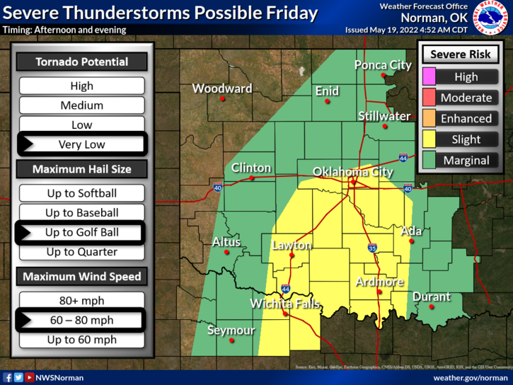
The Oklahoma City metro area was expected to see highs near 92 degrees Thursday, but fire weather could give way to stormy weather by Friday afternoon, meteorologists said. Whether storms develop or not, however, is highly conditional.
"There's going to be a strong cap overhead, and it's going to depend on if we can get enough convergence along with it to see thunderstorms Friday afternoon and evening," said Vivek Mahale, a meteorologist with the National Weather Service in Norman.
If storms do develop, parts of the state could see golf ball-size hail and damaging wind gusts between 60 and 80 mph. But tornado potential was expected to be "very low," forecasters said, and there was a possibility severe weather might not develop at all.
More: Seminole endured a devastating tornado. Now residents face supply chain shortages.
What is not in doubt are cooler temperatures over the weekend, as a strong cold front is expected to move through the state.
"For Saturday, right now our forecast high is 75, and then in the 60s for the high Sunday and Monday," Mahale said. "The low on Sunday morning might be as cold as the upper 40s for Oklahoma City."
The drop in temperatures is expected to persist into midweek as the Memorial Day holiday approaches, with meteorologists predicting a high of 74 on Wednesday.
This article originally appeared on Oklahoman: Possible storms in OKC Friday ahead of cooler weekend

