'Cone of heat' expected to bring potentially dangerous summer swelter to northeast Kansas
WIBW-TV chief meteorologist Jeremy Goodwin expects a potentially dangerous heat wave Wednesday and Thursday to cause Topeka temperatures to leap into triple digits for the first time this year.
After highs here topped out at 92 degrees Monday, Goodwin's station predicted on its website that the mercury would reach about 100 degrees Wednesday and 101 Thursday, with heat indices potentially getting as high as 110.
This week's heat wave will be "rough" but brief, Goodwin told The Topeka Capital-Journal.
High temperatures by Saturday will "cool down" to the upper 80s, he said.
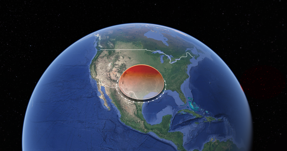
'Heat dome' brought record highs to Texas

The heat here will result from the northward expansion of a "heat dome" that has gripped Texas for days, causing record-breaking high temperatures in Texas.
A heat dome occurs when a persistent region of high pressure traps heat over an area, said William Gallus, professor of atmospheric science at Iowa State University.
Texas cities that set or tied all-time record-high temperatures included Del Rio and Laredo, both with 115 degrees, and San Angelo, with 114 degrees, USA Today reported. The heat index reached an unofficial record of 125 degrees at Corpus Christ, Texas, it said.
Heat dome expected to expand
As of Monday, more than 45 million Americans lived in a place where some level of heat alert was in effect, the National Weather Service said.
That figure should increase Wednesday as the heat dome expands into areas that include Kansas, while also pushing the existing jet stream north.
Jet streams are relatively narrow bands of strong wind in the upper levels of the atmosphere, which follow the boundaries between hot and cold air.
Jeremy Goodwin: Jet stream anomaly meant fewer tornadoes in Kansas
For much of June, a "split jet stream flow" was present over North America, Goodwin said.
"The northern branch formed a persistent ridge of high pressure that climbed well into Canada," he said. "Those of us who watched storms pop up several afternoons in a row earlier this month, moving slowly from east to west, would have noticed the pattern was unusual for June."
The southern branch of the jet stream remained over the Deep South for the first part of June, then moved to northern Texas and Oklahoma in the middle of that month, Goodwin said.
"The hottest weather and extreme humidity from the Gulf Of Mexico tends to be kept south of this subtropical jet stream," he said. "The boundary also tends to guide the worst severe weather."
That meant that tornadoes that would usually torment Kansas each June formed instead in north Texas and Oklahoma, Goodwin said.
The entire state of Kansas has seen four tornadoes this month, all coming on one day, and the state's average for June is more than 20, he said.
Meanwhile, north Texas and Oklahoma are seeing an above-average number of tornadoes, Goodwin said.
Heat index in July likely to break 100 degrees 'over and over'
The good news about this week's burst of hot weather is that the jet stream pattern will continue to move, dropping high temperatures to Topeka to the upper 80s by Saturday, Goodwin said.
"There is bad news about the jet stream pattern overall, as El Nino is projected to bring the Midwest a significant and persistent ridge in the jet stream during July," he said. "This means we will tend to be drier than normal and warmer than normal."
A "hot and dry July" in Kansas means the heat index here will break 100 degrees on "quite a few days," Goodwin said.
"While northeast Kansas hasn't been in extreme drought, much of the state and surrounding states do have extreme drought," he said. "Dry ground heats faster. As we get deeper into July, it is extremely likely that we will see the "heat index" break 100 over and over."
Heat wave not expected to break any records
This week's heat wave shouldn't break any temperature records for the date Wednesday or Thursday in Topeka, where the top mercury readings on record are 106 for June 28, set in in 2012, and 106 for June 29, set in 1933.
The National Weather Service's Topeka office doesn't maintain official records of heat index extremes, but that office began keeping unofficial records of heat index readings in 1978, Capital-Journal archives show.
Topeka's unofficial record heat index record is thought to be 121 degrees, recorded in 2017.
Contact Tim Hrenchir at threnchir@gannett.com or 785-213-5934.
This article originally appeared on Topeka Capital-Journal: Heat wave anticipated to move Wednesday into northeast Kansas

