Cool temperatures in South Florida will last through midweek, then we can expect a warm-up
An early-season cold front freed South Florida from oppressive heat and molten air early this week with promises of even cooler temperatures through Tuesday.
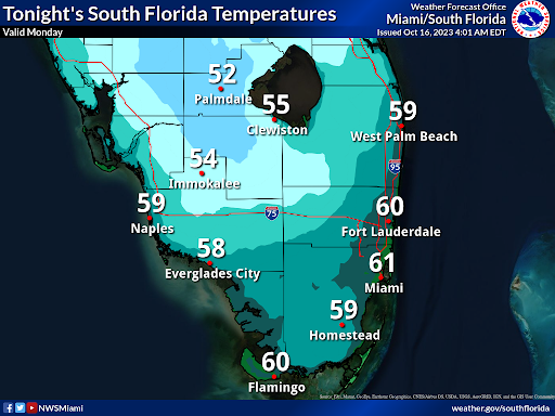
The first significant sweep of northern chill dropped morning lows into the mid-60s Monday with the high temperature in West Palm Beach reaching just 79 degrees — six degrees below normal.
On Tuesday morning, lows could dip to the upper 50s at Palm Beach International Airport. If that forecast holds true, it would be the first time since March 21 that the temperature fell below 60 degrees.
“It’s actually comfortable out,” said Jon Rizzo, the warning coordination meteorologist at the National Weather Service in Key West where the coolest air is expected to drift in early Wednesday. “The biggest thing is the drop in humidity.”
The cold front, which carried a blast of Canadian air through the Peninsula and into northern Cuba, is being reinforced by an area of high pressure that is keeping winds coming out of the north and northwest into Wednesday.
Normal temperatures in West Palm Beach for this time of year are daytime highs of 85 degrees with overnight lows of 71.
Tuesday’s forecast high at the airport is just 75 degrees.
Fall is here: Bird migration has started with some unruly starlings crashing the sojourn south
“For those who enjoy cooler temperatures and crisp mornings, this will be the perfect setup,” said NWS meteorologist Brendan Schaper in Melbourne.
The break of drier, cooler air comes after a 93-degree day on Thursday in West Palm Beach, which tied the record high for that day set in 1946.
Miami International Airport reached 95 degrees on Friday, breaking the previous 93-degree record set in 1990. Fort Lauderdale/Hollywood International Airport measured 93 degrees Friday, breaking its record of 91 degrees set in 2006.
Cold fronts can be fickle in South Florida in the fall, but by late October and early November, more reliable forays of Canadian chill begin to venture down with the plunging jet stream. The average normal overnight low temperature in West Palm Beach doesn't hit 60 degrees until Dec. 14. The average normal high temperature dips to 75 degrees about a week later.
While some of South Florida's most pernicious invasive species, such as cold-blooded green iguanas and Burmese pythons, dislike cooler temperatures, it takes more than a few nights in the 50s and 60s to cull their numbers. Green iguanas, which, like pythons, warm themselves by basking in the sun, can become immobilized when temperatures hit between 40 and 50 degrees. If there are many consecutive days of cloudy skies, the paralyzed iguanas become easy prey to vultures, bobcats and coyotes.
Also, when the lizards are immobilized by the cold, the lizards' digestive systems sour and they die from bacterial infections. Iguanas that fall from trees onto streets are also in danger of becoming road kill.
Pythons have an advantage that iguanas don't — they can generate heat by shivering.
The last significant die-off of iguanas and pythons caused by cold weather occurred during the winter of 2010 when between Jan. 2 and Jan. 13, West Palm Beach's overnight lows dipped into the 30s nine times.
For Palm Beach, Broward and Miami-Dade counties, it was the coldest 12-day period since at least 1940, according to the National Weather Service. By the end of February, the NWS declared 2010 the coldest winter for South Florida in three decades.
A study published later that year by University of Florida wildlife ecology professor Frank Mazzotti and colleagues found that some pythons who died during the cold spell didn't seek shelter from the cold. Others, however, did find burrows to hide in during the cold and survived. It was unclear whether the survival behavior was learned, genetic, or happenstance.
"While it is indisputable that large numbers of pythons died, attempts to interpret these deaths with respect to python ecology are complicated by a number of factors, including behavior, availability of refuges, and unknown variation in detection probabilities," the study said.
By Wednesday, temperatures will begin to creep back to normal with highs near 80 degrees and overnight lows in the mid-70s.
“This period of cooler conditions won’t last very long,” said Ana Torres-Vazquez, a meteorologist with the NWS office in Miami. “But, it’s very quiet weather for the rest of the week with low rain chances.”
The rainy season officially ended Oct. 15 for the seven counties overseen by the Miami office of the NWS — Miami-Dade, Monroe, Broward, Collier, Palm Beach, Glades and Hendry. Still, a coastal flood statement is in effect through at least Tuesday afternoon with Saturday's new moon still tugging at the high tides.
The clear skies this week could offer a better glimpse of the Orionids meteor shower. Although the shower is active from late September to Nov. 22, it peaks this year late Friday through early Sunday. Halley's comet is the source of the Orionids, although it is named for the celestial hunter Orion.
Kimberly Miller is a veteran journalist for The Palm Beach Post, part of the USA Today Network of Florida. She covers real estate and how growth affects South Florida's environment. Subscribe to The Dirt for a weekly real estate roundup. If you have news tips, please send them to kmiller@pbpost.com. Help support our local journalism, subscribe today.
This article originally appeared on Palm Beach Post: South Florida cold front drops temperatures into 60s but will not last
