Cooldown slows Utah's snowmelt, but 3 flood warnings remain in place this week
Utah's spring snowmelt slowed down a bit over the weekend, as scattered showers and cooler temperatures impacted the state.
While that reduced some flood threats, three flood warnings remain in place Monday, according to the National Weather Service.
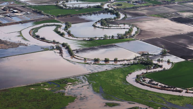
Bear River (below Woodruff Narrows Reservoir in Wyoming to Rich County, Utah; also between Cutler Dam in Cache County to the Great Salt Lake): The river is forecast to be near or above its flood stage at both locations for the "foreseeable future," and the warning will remain in place until further notice. The high waters are expected to impact agricultural areas and low-lying roadways by the river in both sections of the warning.
Ogden River (south fork near Huntsville): The river is forecast to rise above the flood stage (992 cubic feet per second) at times over the next few days, with a possible peak of 1,316 cubic feet per second by late Thursday morning. Minor flooding is expected to impact any low-lying areas near the banks of south fork of the Ogden River below Causey Reservoir through the town of Huntsville. Moderate flooding is possible if the river reaches 1,599 cubic feet per second.
Sevier River (near Hatch, Garfield County): The river's flow is expected to remain close to or above flood stage through at least mid-May. Minor flooding is expected to impact fields and any low-lying structures by the river.
Flood watches are also in place for the Cache Valley and the northern part of the Wasatch Front. The agency advises that excessive runoff could lead to more flooding in areas close to the Little Bear River below Hyrum Reservoir, as well near the lower Weber River by Plain City. The alert for the Little Bear River continues through at least Friday afternoon, while the lower Weber River alert remains in place until further notice.
Utah's snowmelt so far
About 18.3 inches of snowpack remained in Utah's statewide total Monday morning, according to Natural Resources Conservation Service data. This means about 60% of this year's record snowpack is still in the mountains, waiting to melt into the state's creeks, rivers and streams.
A low-pressure system that passed through the state just before the weekend did slow down the snowmelt's torrid pace. The agency notes that 7.8 inches of the statewide figure melted between April 25 and Friday, or about 0.7 inches per day over that stretch. It melted at a rate of 0.17 inches over the weekend.
Most of the remaining snowpack is in northern Utah. The Weber-Ogden (30.4 inches) and the Provo-Utah Lake-Jordan (27.5 inches) snowpack basins currently hold the most water among the state's basins.
Meanwhile, basins in southern Utah are getting near the end of their spring runoff periods. For example, more than three-fourths of the Escalante-Paria basin's 19.1 inches have melted since April 7. It has 4.5 inches left, as of Monday. Southwestern Utah is also down to 9.1 inches, melting 19.5 inches over the past month.
This week's forecast
KSL meteorologist Matt Johnson said another low-pressure system off the Pacific Coast is expected to cross through Utah, bringing more scattered showers and thunderstorms across the northern half of the state Monday afternoon into the evening. Some additional showers are expected on Wednesday; however, temperatures are expected to warm up a little bit from the highs in the mid-60s over the past few days.
High temperatures along the Wasatch Front are currently forecast to top out in the low 70s through the rest of the workweek, which is a few degrees warmer than Saturday or Sunday but very close to normal for this point in the year. High temperatures are expected to top out in the mid-60s in the Cache Valley.
This is expected to allow the snowmelt to continue at a normal pace, though creeks, rivers and streams will likely remain flowing faster than usual. The next warmup beyond seasonal temperatures could begin this weekend, which would lead to more flooding risks.
Excessive snowmelt combined with reservoir releases in the upper Bear River is already flooding agricultural land and is about to get worse. Current forecast calls for river levels in the Woodruff, UT to Cokeville, WY area to exceed the historical peak by early next week! #utwx pic.twitter.com/UWmtR6eivw
— Matthew Johnson (@KSL_Matt) May 8, 2023
Johnson points out that the Bear River is one of the waterways most at risk because of reservoir releases, as well. Current forecasts of the river in the Woodruff area soaring to record status by next week.
A long way to go
Utah's creeks, streams and rivers are expected to remain high for at least the next several weeks as the rest of the snowpack melts, Alex DeSmet, a lead meteorologist at the National Weather Service, told KSL.com last week.
"There is still a lot of snowpack, especially in the higher-elevation areas," he said. "It depends on the nature of our warmups here as we go through the next several weeks but there's a high chance for high flows to remain with us across the state into June, possibly through June as well."
Full seven-day forecasts for areas across Utah can be found online, at the KSL Weather Center.

