Cooler temperatures, heavy rain, flash flood warnings for OKC weather Monday, Tuesday
Severe thunderstorms brought heavy downpours and flash flooding potential to southern, central and eastern parts of Oklahoma Monday and Tuesday.
Storms developed late Sunday in the Texas Panhandle and continued to move northeast through Oklahoma Tuesday morning, a product of a cold front that began Saturday after unseasonably hot temperatures last week.
More: Heavy rain, lightning fires, possible tornadoes in Oklahoma City's Monday weather forecast
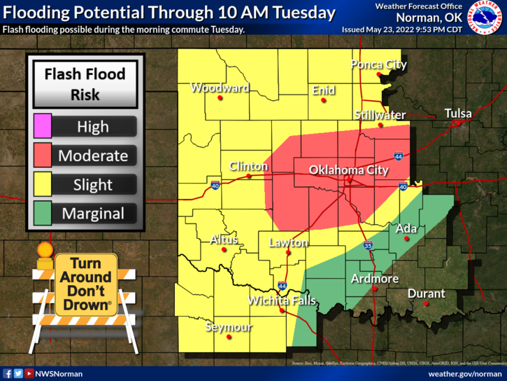
Increased flood potential, but low tornado potential Tuesday
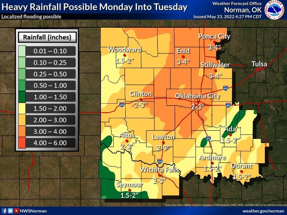
By Monday night, the Oklahoma City metro had seen between 2 to 3 inches of rainfall, meteorologists said, with more rain expected to pass through the area until Wednesday.
The National Weather Service issued a flood watch for areas along and northeast of Interstate 44. Cities sitting in a forecast zone from Binger to Stillwater were the most susceptible to flooding, the weather service said.
A "marginal risk" of severe thunderstorms was expected Tuesday afternoon into evening for areas in the Oklahoma City metro and west-central Oklahoma, according to the weather service. Winds of 60 mph and quarter size hail were the main threats, meteorologists said, but the tornado potential for the forecast area was low.
"Most of the heaviest rain is going to be down in portions of southeast Oklahoma along the Red River (Tuesday) night, with scattered showers possible for central and northern Oklahoma," said meteorologist Phillip Ware.
Power outages, traffic accidents increase, but reprieve expected Memorial Day weekend
By 9:35 a.m. Tuesday, Oklahoma Gas & Electric Co. reported over 1,500 customers were without power due to the storms, with more than 1,000 people in the Oklahoma City area among the most impacted.
Major flooding was reported near the intersection of NW 4 and N Macarthur Blvd, and cars were seen stranded on the sides of the roadway.
As the day continued, the Emergency Medical Services Authority for the Oklahoma City area began receiving increased calls concerning traffic accidents.
Adam Paluka, EMSA’s chief public affairs officer, said Tuesday afternoon the number of vehicular crashes had doubled from the daily average.
More: Severe weather causes surge in OKC car accidents
Rain was expected to continue throughout Oklahoma until Wednesday, but experts believed the storm clouds would dissipate by Thursday, after which warmer temperatures should begin to return.
"It looks like we could see rain for both the morning and evening commutes Wednesday," Ware said. "It's going to take a little bit of time to recover, and we're seeing low 70's in the forecast for Thursday. But for Memorial Day weekend, it's looking pretty dry and hot. We'll be back in the upper 80s, low 90s by then."
What is a flash flood watch or warning? Here's what to know about this deadly weather hazard
Until the risk of localized flooding subsides, the National Weather Service recommends safety precautions to residents making their daily drives.
Have multiple ways to receive warnings.
Avoid driving through flooded roadways, which are especially dangerous at night because you can't see how deep the water might be.
"Turn Around, Don't Drown!"
Avoid spots with creeks and drainage ditches, and seek higher ground if you find yourself in a flood-prone area.
This article originally appeared on Oklahoman: Heavy rainfall, flash flood weather warnings in OKC and Oklahoma Tuesday

