The cost of maintaining Outer Banks highway
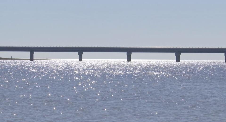
After nearly a decade of planning, four years of construction, and $155M, those who live, work, and play in the Outer Banks got their first chance to drive into Rodanthe over the new jug handle bridge in July 2022.
The Rodanthe Bridge spans 2.5 miles, stretching into the Pamlico Sound to bypass what engineers, tourists, and locals know as the biggest trouble spot along N.C. Highway 12.
READ MORE: The Outer Banks prepare for the impact of rising sea levels
Pablo Hernandez, who helped design and build the jug handle bridge, said in his first four years with the North Carolina Department of Transportation, he rebuilt the former “S-curves” section of Highway 12 north of Rodanthe, three times. The first was in 2009 after Hurricane Ida.
“At that time, we made a decision to try to scooch the road over to a little bit farther from the ocean,” he said. “Then again in 2011 after Hurricane Irene and then again after Hurricane Sandy in 2012.”
Even in years without a major storm, the S-curves proved to be a trouble spot, according to Jeff Ryder, one of the maintenance engineers.
He is responsible for reconstructing protective sand dunes and responds to overwash along the roadway.
“It was notorious for flooding and closing the road even on the most beautiful days in the summer,” he said.
Flooding has left homes and businesses along the Cape Hatteras National Seashore inaccessible from the north for hours, or in serious circumstances, prompt emergency ferry services.
“That impact to the business community, as well as just the standard of living, there’s a significant intangible cost to that as well,” Hernandez said.
Preparing NC 12 for the future
The NC 12 Task Force was formed in 2021 to look at problem areas, including the s-curves in Rodanthe, and help determine what infrastructure changes are necessary to keep the road open for today’s conditions. The task force also prepares for an anticipated 10-14 inch rise in sea levels.
With input from the NCDOT, Hyde, and Dare counties, National Parks, the Army Corps of Engineers, local business owners, and the Coastal Studies Institute, the latest task force report mapped out six hot spots along NC 12 and gave their short-and long-term recommendations.
READ MORE: Bridge designed to avoid flooded road to Outer Banks opens on NC coast
With the jug handle bridge removing the s-curves from consideration, the new, persistent trouble spot is on the north end of the Cape Hatteras National Seashore, near the Pea Island Visitor’s Center.
“There’s just not enough beach and the ocean is very close to the protective dune system,” Ryder said of that stretch of road.
All long-term recommendations to make that spot more sustainable include building another bridge, including a potential 10-mile bridge bypassing that section of the island entirely and connecting the Oregon Inlet Bridge to the new jug handle bridge. This would be twice as long as the 5.2-mile Virginia Dare Bridge, currently the longest bridge in North Carolina and also in Dare County.
However, the report acknowledges that kind of change will come with a massive price tag and likely a years-long permitting process.
The cost of doing business
The status quo isn’t cheap either.
Currently, Ryder said the NCDOT’s maintenance engineers are focused on building and rebuilding protective dune systems around these hot spots.
“We have to haul some sand from another location that has an abundance of sand down to an area that needs the sand very badly,” he said.
According to data from NCDOT, maintenance on the less than 50-mile stretch on NC 12 along the Cape Hatteras National Seashore has cost about $9.6 million over the past 10 years. That excludes the $33.5 million that the DOT has received for emergency repairs following disasters.
Year | Maintenance Total | Disaster Total |
|---|---|---|
2022 | $1,555,001.60 | $129,877.99 |
2021 | $756,655.93 | $290,384.48 |
2020 | $999,993.96 | $180,469.33 |
2019 | $1,182,396.27 | $248,395.12 |
2018 | $928,851.47 | $11,476.52 |
2017 | $1,007,101.88 | N/A |
2016 | $1,707,067.42 | $1,101,720.09 |
2015 | $1,862,534.96 | $2,345,645.89 |
2014 | $2,194,162.48 | N/A |
2013 | $1,710,706.95 | N/A |
2012 | $762,304.03 | $29,238,221.16 |
Total | $9,592,745.55 | $33,546,190.58 |
While crunching those numbers, the state also has to weigh the economic significance of the islands. The National Park Service’s annual report showed Cape Hatteras National Seashore also brought in $865 million in economic output to the region last year.
“You had to go with the worst of the worst and you had the get the most bang for your buck,” Hernandez said.
That’s why Hernandez believes resilient structures like the jug handle bridge are priceless.
It was built, not only to withstand the worst storms the Outer Banks has seen in the past but with the knowledge that future storms will bring water an additional 10-14 inches higher. Hernandez hopes it will keep the region accessible decades into the future.
So far, it’s only had a few tropical systems to test its defenses, but since the bridge opened, the NCDOT reports it’s only closed once, which was for just a few hours due to issues further north on the island.

