Could Hurricane Idalia make a return trip to Florida? Another storm did.
DEBARY, Fla. — Anyone keeping tabs on Hurricane Idalia’s path might be doing a double take at a few of the computer models predicting a loop in the Atlantic Ocean and a return to Florida for a second landfall next week.
At least two models have shown runs that include a loop back toward Florida after the tropical cyclone emerges into the Atlantic Ocean, said Gus Alaka, a meteorologist with the National Oceanic and Atmospheric Administration.
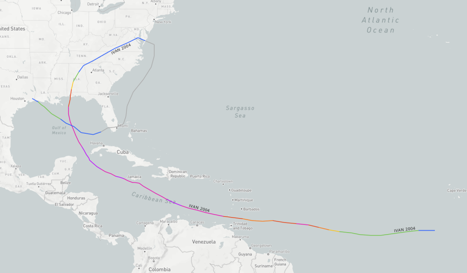
If that sounds familiar, Hurricane Ivan followed a very similar path in the midst of the wild 2004 hurricane season that saw Florida struck four times.
"The most famous (or infamous) looping storm has to be Ivan," said Phil Klotzbach, a hurricane researcher at Colorado State University.
Like Idalia, Ivan moved between Cuba and the Yucatan and traveled north in the Gulf of Mexico. After making landfall in Alabama and pushing through the Carolinas, Ivan traveled southward in the Atlantic then crossed over South Florida as a tropical depression, and made a third landfall in Louisiana.
Ivan and Co.
Ivan wasn’t the only hurricane to accomplish a loop during the hectic 2004 season. Hurricane Jeanne did a loop in the Atlantic before its eventual landfall in Stuart in South Florida.
Klotzbach's personal "loopy" favorite is Hurricane Ginger in September 1971. It traveled east of Bermuda, completed two loops in the Atlantic, and eventually made landfall in North Carolina.
At least nine other storms since 1963 have made some kind of loop as prevailing currents pushed them around, either before landfall or after returning to the ocean. That doesn't include storms that looped around over land while dissipating.
On Tuesday, the more pressing question on the minds of Floridians was just where Idalia would wind up along Florida’s Gulf Coast Wednesday morning and how strong it would be.
What is Idalia's track forecast?
The hurricane is expected to take advantage of extremely warm waters in the Gulf of Mexico and rapidly intensify before a potentially historic strike along Florida’s Big Bend region with a catastrophic storm surge of up to 15 feet and winds of up to 115 mph.
As Idalia crosses over Florida into Georgia and South Carolina and emerges into the Atlantic, it could be moving so quickly it might retain its hurricane status, the National Hurricane Center said in a Tuesday afternoon forecast discussion.
Beyond Friday, the center shows Idalia as a tropical storm drifting nearly stationary between the U.S. and Bermuda.
HURRICANE SEASON: Idalia's path goes through hot waters in the Gulf of Mexico. That's concerning.
What happens after Idalia moves back into the Atlantic?
One model, the Global Forecast System, commonly known as the GFS, has consistently shown Idalia’s remnants moving back over south or central Florida. Alaka said that particular model has made similar projections before.
"It’s very rare" for a storm to make landfall in the Gulf and then emerge into the Atlantic, then circle back, he said. "But it’s certainly something to watch for next week."
One ensemble model, the European Center for Medium-Range Weather Forecasts model, has several members showing the remnants or a weak tropical storm version of Idalia drifting toward the south and essentially hanging out there or curving back toward Florida, Alaka said. "It’s on the table, but that forecast is still five days away."
Even if Idalia does slide back toward Florida, Alaka said "there’s no indication it would re-intensify because of the unfavorable wind shear" in the Atlantic.
A Canadian Meteorological Centre model run also shows the remnants moving over South Florida. Other models show the remnants moving southward or dissipating, but forecasters say it's too soon to say what could happen.
An unlikely scenario
It's hard to forecast further than a week out, and errors grow as the forecast time lengthens, said Kole Fehling with the National Weather Service office in Melbourne, Florida. "Right now, given the time that it’s a week or so out, (our) confidence is pretty low."
Some of the model solutions take the remnants "back into the eastern Gulf of Mexico, which is the last place we want to see anything at this point," said meteorologist Josh Nagelberg of Perry Weather.
Whatever happens off the East Coast could be influenced by Hurricane Franklin’s passage, Nagelberg said. It's likely Franklin's passing would cool the surface waters in the ocean, providing an additional obstacle to Idalia's future.
'KIND OF USED TO IT': Not everyone chooses to flee possible monster Hurricane Idalia
Other hurricanes and tropical storms with looped tracks
A search of NOAA's database reveals a little history behind the tracks of nine other storms:
Hurricane Ginny in 1963 made not one but two loops, one big one east of Jacksonville, Florida, then a smaller one east of the Outer Banks, before finally making its way to a landfall in Nova Scotia.
Hurricane Isbell in 1964 looped in the northwestern Caribbean, then crossed the tip of Cuba and made landfall in Southwest Florida.
Hurricane Betsy in 1965 traveled a long distance from the eastern Atlantic and then turned to the north off the Florida coast. A change in steering conditions resulted in a little loop, then a path south through the Bahamas and a landfall in Louisiana.
Hurricane Diana made a tight little loop just east of Wilmington, North Carolina, in September 1984, before making landfall there and exiting over the Outer Banks.
In 1985, Hurricane Elena traveled almost the entire length of Cuba and then into the Gulf of Mexico before making a hard right toward Florida’s east coast. The steering currents then pushed the hurricane into a short loop, then westward to a landfall between New Orleans and Mobile, Alabama.
Hurricane Lili made a loop in the northwestern Caribbean Sea in October 1996, then crossed over Cuba before heading out to sea.
Hurricane Dennis, in 1999, also looped around east of the Outer Banks and then circled back for a landfall in North Carolina.
Tropical Storm Edouard made a loop of the Florida coast and made landfall in Ormond Beach, then crossed the state into the Gulf of Mexico in September 2002.
In the midst of a hurricane season that saw five Florida landfalls in 2005, Hurricane Ophelia made a loop off Central Florida in September, then moved on, doing a second loop east of Georgia, before heading to landfalls in Nova Scotia and Newfoundland.
This article originally appeared on USA TODAY: Hurricane Idalia forecast: Could storm make a second trip to Florida?

