Could Hurricane Idalia make a second run at Florida after battering its west coast?
Idalia’s menace is focused on Florida's Gulf Coast, but a blocking swirl of high pressure above the mid-Atlantic region may send it looping back toward the state over the long Labor Day weekend, according to one reliable hurricane model.
The National Weather Service (NWS) in Miami mentioned the potential for a “return trip to Florida” by Idalia, or, more likely, its remnants, in its Tuesday forecast. The NHC said it’s possible the stream of westerly winds Idalia is riding could leave the storm behind once it reaches the open waters off the coast of the Carolinas.
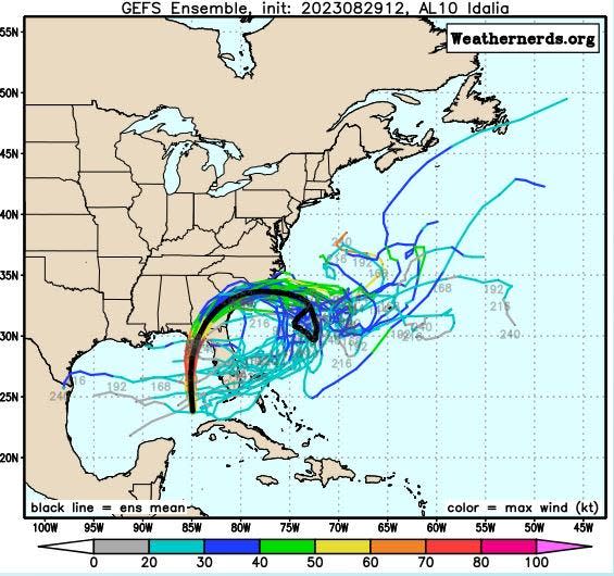
If Idalia stalls, the GFS, or American model, showed that it could get trapped under a clockwise churn of winds that would boomerang it back to the Sunshine State.
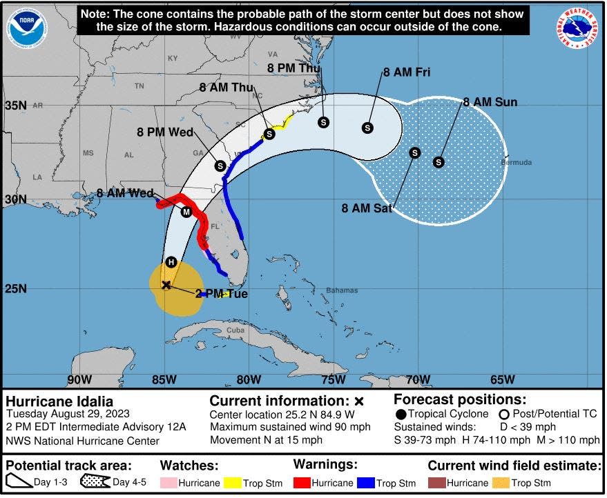
“Idalia’s return trip to Florida still isn’t the most probable solution looking at the ensemble spread but does seem to have risen into the realm of being plausible,” Miami meteorologists wrote in their Tuesday forecast.
It’s unlikely Idalia would maintain its tropical title on its second run at the state, but the forecasters noted that sea surface temperatures 3.5 to 5 degrees warmer than normal could help it reenergize.
What it would mean to South Florida is unclear.
Hurricane prep: Everything you need to know for the 2023 season
It could just be a meteorological eccentricity bringing no foul weather with it. The National Weather Service (NWS) forecasts are limited to seven days and show Labor Day in West Palm Beach as mostly sunny but with a 60% chance of showers.
“Basically, it’s a little messy at this point,” said Sammy Hadi, a meteorologist in the NWS Miami office about Idalia’s long-term forecast. “It could stall, but that would be more in the Saturday or Sunday timeframe and it’s too early to speculate at this point.”
Still, meteorologists Bob Henson and Jeff Masters said in their Eye on the Storm column for Yale Climate Connections that while Idalia’s long-term fate is muddled, the GFS model predicts Idalia will loop back across Florida and head full on into the Gulf of Mexico once again.
Don't miss this celestial oddity: A rare super blue moon rises Aug. 30 following this month's full sturgeon moon
“Such loops are not unprecedented,” the duo wrote.
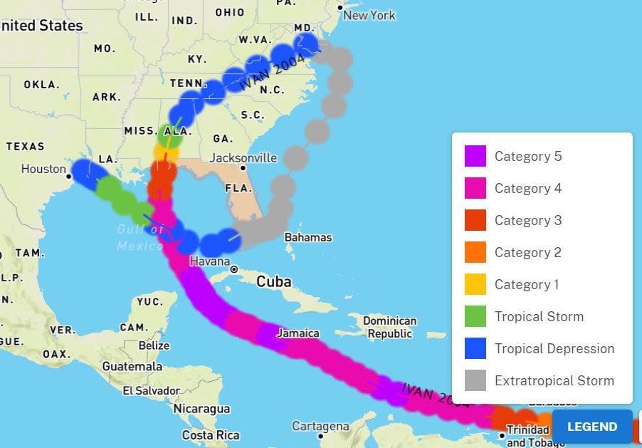
In 2004, hurricanes Ivan and Jeanne both did cartwheels before hitting southeast Florida.
Ivan made landfall as a Category 3 hurricane near Gulf Shores, Alabama, on Sept. 16, 2004. It headed north, made a U-turn in Maryland, and came back to South Florida as a harmless extratropical storm.
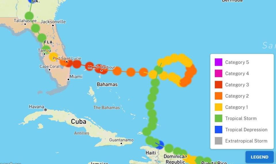
Jeanne lingered in the far off Atlantic for days adrift in a weak steering flow before doing a loop about 500 nautical miles east of the northwestern Bahamas that put it on a path toward Florida. Jeanne made landfall as a Category 3 hurricane on Hutchinson Island on Sept. 25. It was the same place Hurricane Frances made landfall three weeks earlier.
Hurricane and storm surge expert Michael Lowry also noted in his forecast Tuesday that while most models show Idalia taking a softer turn south after entering the Atlantic, the GFS model hooks it back to Florida as a “much weaker redux.” Lowry is a meteorologist with South Florida ABC affiliate, Channel 10
“We’ll of course continue to monitor the trends for any shenanigans next week,” Lowry said.
Kimberly Miller is a veteran journalist for The Palm Beach Post, part of the USA Today Network of Florida. She covers real estate and how growth affects South Florida's environment. Subscribe to The Dirt for a weekly real estate roundup. If you have news tips, please send them to kmiller@pbpost.com. Help support our local journalism, subscribe today.
This article originally appeared on Palm Beach Post: GFS model shows Idalia making a loop, heading back to Florida

