Iowa counties along the Mississippi River brace for potentially record-breaking flood levels
Gov. Kim Reynolds has issued a disaster proclamation as counties along the Mississippi River prepare for potentially record-breaking water levels.
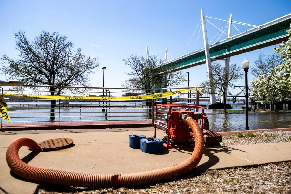
The areas along the Mississippi River have faced flood conditions for the past two weeks as the river's water levels have risen due to melting snow. The river skipped its banks in Davenport on Wednesday morning, and Dubuque is prepared to close all of its floodgates for only the third time since they were installed 50 years ago.
According to National Weather Service's predictions, peak flood conditions are still days away.
Here's what forecasters are saying about potential flood levels and what cities and counties are doing to prepare.
Where might record flooding occur?
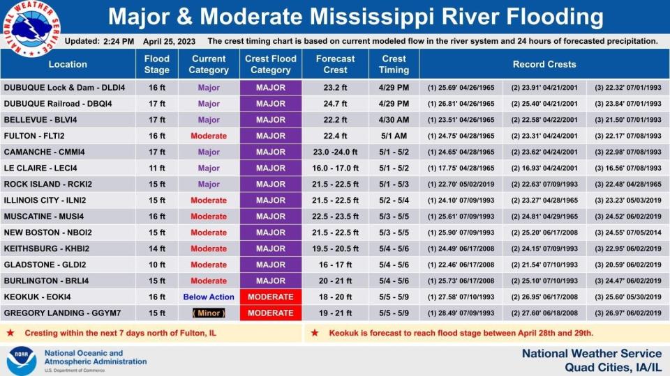
The National Weather Service in the Quad Cities expects at least 13 counties along the Mississippi River to be under a major flood risk now through May 9.
Most regions are expected to experience near record-breaking crests in coming days. John Haase, a meteorologist for the National Weather Service in the Quad Cities, defines the "crest" as the highest water level the river is expected to reach before it starts to fall.
The river near Bellevue, for example, is already experiencing major flooding, with water levels having reached over 21 feet as of Thursday afternoon. By Sunday morning, NWS predicts flooding levels in that area will reach a crest of up to 22.2 feet, which would be the third-highest in the city's history.
What's causing the rising water levels?
The potential record-breaking flooding is a result of a rapid snowmelt from the north that's making its way into the Mississippi River, according to Haase.
"(The river) just can't handle that rapid of a snowmelt when you've had that much snow that has occurred to the north," he said. "Twin Cities had anywhere from 90 to 100 inches (of snow), and that's like 40 to 50 inches above normal."
After that high volume of snow accumulated in the north, Haase said, the region experienced temperatures that reached between 80 and 90 degrees, which quickly melted the snow and sent it off south down the river. Coupled with some heavier rain in eastern Iowa, Haase said, conditions were ripe for potentially record-breaking flooding.
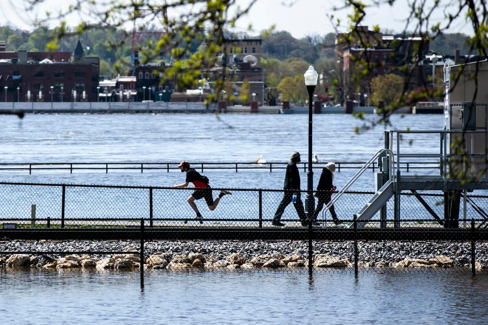
River flows over banks in Davenport
Water flowed over riverbanks in Davenport on Wednesday morning, flooding nearby roads and parking lots. River levels there are still nearly a week away from their peak, according to the National Weather Service.
Davenport and surrounding cities like Rock Island are currently at major flood stage. As of Thursday afternoon, river water levels had risen to nearly 20 feet, according to the NWS office based in the Quad Cities. The river is expected to crest between 21.5 and 22.5 feet May 1 to May 3. If water levels reach the maximum prediction of 22.5 feet, it will be the third-highest crest in recorded history.
The police department has closed both east and west lanes of River Drive from Rockingham Road to Bettendorf as a result of the flooding.
Dubuque prepares to close all floodgates for only the 3rd time
The city of Dubuque is preparing for the third-highest crest ever recorded. The river is expected to reach up to 24.7 feet by Saturday afternoon or evening.
The city and surrounding areas are facing major flood risks as river levels have already risen to nearly 24 feet by Thursday afternoon. However, city Public Works Director John Klostermann said the city's floodwall and other prevention protocols have spared the city from any damage so far even as water levels continue to rise.
"The floodwall/levee protecting most of the city is operating as designed and City staff are now monitoring it around the clock for any signs of issues," the city wrote in a Facebook post. "Public Works staff have also closed 13 of the 17 floodgates along the river and are operating four permanent pumping stations and three temporary pumps 24/7 to convey water over the floodwall and into the river."
The post said the remaining four floodgates will be closed by the end of the week, which is only the third time in history all the floodgates have been closed since the system was implemented in 1973.
Klostermann said the city also is employing further flood prevention tactics at Schmitt Island, which is not protected by the city's flood wall.
"That's all going in the right direction," Klostermann said. "Now we've got to get through the next three or four days of rain but I think we will be in good shape."
The city is still warning residents to proceed with caution over the next few days while river levels continue to rise.
"The public is reminded to be cautious around the river and floodwall and to avoid flooded areas and follow all traffic detours. City staff also ask that the public avoid areas where they are working on flood control so they can complete this critical work as quickly and safely as possible," the city wrote on Facebook.
How other cities, counties are preparing
Counties all along the Mississippi River in Iowa are implementing emergency procedures to brace for potential floods.
Lyn Medinger, the emergency management coordinator for Jackson County, which includes the cities of Bellevue and Sabula, said the county has so far experienced only minor flooding on agricultural land and a few campgrounds. He added that a few buildings in Bellevue have been impacted by rising water levels.
In Sabula, Medinger said city workers are checking the levee every hour to ensure there are no leaks in the system. The city also posted on Facebook that workers started sandbagging on Monday to prevent any flood damage.
Even as water levels rise, Medinger said he does not expect to see more serious flood damage in Jackson County.
Louisa County, located a little farther downriver, is implementing similar procedures ahead of expected flooding. Emergency Management Coordinator Brian Hall said the county is preparing sandbags and monitoring the levee, while also focusing on what to do in case flooding turns more severe.
"What we've done is alerted some of the local churches to be ready to receive people in the event that there was a catastrophe," he said.
Hall said the county, whose largest city is Wapello, has experienced minor seepage since water levels began rising. He said he expects seep water to intensify as the river reaches around 20 to 21 feet at the crest next week, but he does not expect anything more severe.
"The crest is expected to last only 24 hours and then start back down. We hope that's going to be a speedy event," he said.
Despite his expectations, Hall recommended residents pay close attention to weather updates and to be "prepared to move at a moment's notice in case things were to go wrong."
Where is the disaster proclamation in effect?
Iowa Gov. Kim Reynolds issued a disaster proclamation for 10 counties along the Mississippi River who are already or are expected to face major flooding. The counties are Allamakee, Clayton, Clinton, Des Moines, Dubuque, Jackson, Lee, Louisa, Muscatine and Scott.
The proclamation unlocks state resources that can be used in the recovery and cleanup of areas impacted by flooding.
As of Friday afternoon, families in Allamakee, Clayton, Clinton, Dubuque, Jackson, Muscatine and Scott Counties with incomes up to 200% of the federal poverty level are eligible to apply for the Iowa Individual Assistance Grant Program, which provides grants of up to $5,000 for weather-damaged assets such as cars, households, clothing or food. Residents in these five counties, regardless of income level, can also reach out to case managers through the Disaster Case Management Program for assistance.
"Iowans who live along the Mississippi River are urged to prepare for possible flooding by having a plan to evacuate if necessary, packing an emergency kit with supplies for several days, staying informed about flood forecasts for their communities, and following information and guidance issued by local officials," a news release from the governor's office said.
The proclamation will stay in effect until May 24.
Tips to stay safe if you're in a flood area
Haase said the No. 1 tip for residents who are unable to evacuate from a flood zone is to avoid driving on roads blocked off by law enforcement.
"Turn around. Don't drown when encountering flooded roads," he said.
The majority of flood deaths occur in vehicles because drivers will skirt around barricades and find themselves on roads with major flooding, he said.
Haase added it's also important for residents to avoid high risk areas like riverbanks, because during flooding "the river would be fast flowing."
Hall, of Louisa County Emergency Management, said residents in flood areas should "watch their weather apps and sign up for mass notifications" so they can be prepared in case of an emergency.
Editor's note: This story has been updated to correct river levels.
Francesca Block is a breaking news reporter at the Des Moines Register. Reach her at FBlock@registermedia.com or on Twitter at@francescablock3.
This article originally appeared on Des Moines Register: Mississippi River flooding in Iowa could break records in some areas

