Creek Fire live updates: 6% containment; Clovis Rodeo full with animals; Oakhurst on watch
We’ve removed the paywall on this story as a public service to provide the broadest access to the latest information. To support local journalists bringing you wildfire information, subscribe to The Bee. (Click on "Subscribe" or the "person" icon in the top right.)
7 p.m.: Finally, some containment
The Creek Fire is at 6% containment, it was announced at Thursday’s nightly update.
Total acreage remained unchanged from the morning at 175,893.
12:45 p.m.: Firefighting resources spread across western U.S.
The number of fires burning across California and the United States has Creek Fire officials fighting for resources.
On the western front of the Creek Fire, those resources are being focused around the North Fork area even as the fire is seeing growth to the northeast.
Fire crews spent much of Wednesday and Thursday cutting lines and doing burning operations around Cascadel Woods.
The weather conditions in the area on Thursday were favorable— even if it didn’t appear as such. The heavy smoke trapped by the inversion layer actually helped to moderate burn conditions.
Similar conditions are expected tomorrow.
The current operations are designed to save lives and structures, according to Michael Davis, an information officer with the Incident Command Post in O’Neals. There has been property damage in the area, but crews have not been in to access exactly which structures have burned.
Those in areas near the fire that have not yet been evacuated should be aware that there are 1,000 firefighters working in the area with trucks and heavy equipment that will be out on the roads, Davis said.
Residents in pre-evacuation areas should spend time preparing for mandatory evacuations, doing things like making sure they have gas in their vehicles and their belongings gathered.
“They need to be ready to leave at a moment’s notice,” Davis said.
At the Incident Command Post in Tollhouse, Capt. Chris Vestal gave this update:
“Thursday was the first day that fire crews near Tollhouse and Shaver Lake could shift their focus to containment. Work is being prioritized in both the east and west as the fire moves southward. Thursday saw favorable weather, with no red flag warnings and major wind events, which gave crews the chance to improve fire lines.
“Of course, the inversion layer is trapping in the smoke, keeping aircraft from being able to drop water or retardant.”
Noon: Clovis Rodeo at capacity for large animals
Fresno County officials reported the Clovis Rodeo Grounds are at capacity and no longer accepting animals evacuated from the Creek Fire.
The Fresno Fairgrounds is set up to receive evacuated animals and has space available.
The Fresno Fairgrounds are located at 1121 S. Chance Ave., Fresno, CA 93702.
Anyone transporting animals there should first contact the Central California Animal Disaster Team at 1-888-402-2238 to finalize arrangements.
11:15 a.m.: Idaho firefighter in North Fork
Road 225 through North Fork appears to be normal.
Nearby, firefighter John Vincent of Blaze Runners Inc. out of Boise, Idaho, outlined the issues along the line:
There are three things that present a challenge when containing a fire like this — topography, fuel and weather, Vincent said.
He was part of a three-man crew working to hold the fire along a stretch of Minarets Road, east of North Fork near Cascadel Woods.
“The wind was moving at 50 miles an hour at Bass Lake yesterday,” Vincent said. “Today, the weather here is cooperating. An inversion layer has kept temperature down and that means less wind.
“Right now, the weather is working in our favor.”
11 a.m.: Cal Fire reports more structural destruction
Cal Fire reported Thursday morning 361 structures, including 60 homes and 277 commercial and residential mixed-use buildings, were destroyed by the fire. Four commercial and 20 other smaller buildings also were destroyed.
In addition, six other residences, two commercial and one smaller building were damaged.
The fire remained 0% contained.
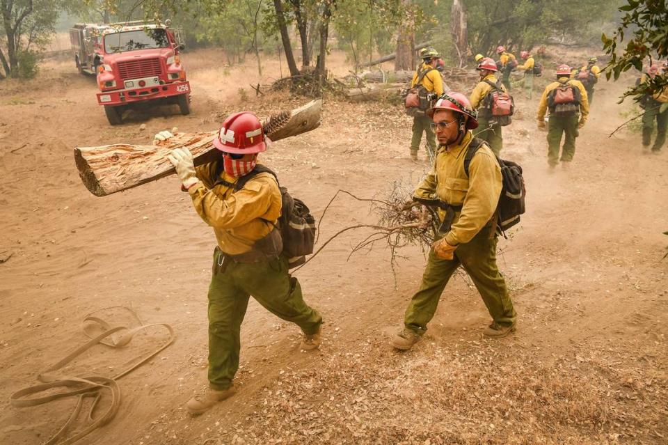
More than 1,300 firefighting personnel are assigned to the fire, using equipment such as fire engines, helicopters, dozers and air tankers.
9:30 a.m.: Near fire’s western edge, Oakhurst on watch
The group that meets for coffee outside Oakhurt’s Cool Bean Cafe most mornings is without a couple members because of the Creek Fire.
One lives outside of Oakhurst in an area inside the mandatory evacuation zone. Another chose to evacuate voluntarily, out of caution.
For the ones who’ve remained, it’s a game of wait-and-see for “a lot of people who don’t know what’s going on,” said Nathan Nielsen.
“Updates and information on the fire come mostly through social media and listening to the scanner — very little direct communication has come from official channels: the sheriff or Cal Fire,” said Nielsen, who lives three miles east of the cafe near Yosemite High School.
“We haven’t heard anything in 48 hours.”
This is not anything new. Nielsen has been evacuated before. The Junction Fire that burned through Oakhurst in 2014 was 100 yards from his house.
Lee Hubert lives west of Oakhurst and said he wasn’t too worried about the fire getting that far. But he’s also prepared with a generator and extra fuel in case the power gets cut off.
“None of us like it, but this is the way it is,” Hubert says.
It’s been a particularly bad year for the community, Nielsen said, first the pandemic and now the fire.
There is some frustration that is built up from locals, who are watching their community suffer while seeing an influx of tourists passing through the area.
“For us the forest is sacred in some ways,” Nielsen said. “It’s where we live. It’s where we raised our family.”
Access to Bass Lake is being blocked by the California Highway Patrol. There is heavy smoke and almost no visibility across the lake.
8 a.m.: Fire past 175,000 acres; find your address on evacuation map
The U.S. Forest Service reported Thursday morning the Creek Fire surpassed 175,000 acres in size. Sixty residences, two commercial structures and 278 other mixed commercial and residential structure have been destroyed.
Firefighting crews are making progress building a containment line from the San Joaquin River northwest toward Castle Peak in Madera County, the forest service reported. Additionally, dozers are removing vegetation near structures in Cascadel Woods.
The U.S. Forest Service also posted an interactive evacuation map for the Creek Fire. The map shows which areas are under evacuation orders and evacuation warnings. The map is searchable so residents can find their address.
To use this map from the National Interagency Fire Center, accept the terms, enter an address or place in the search field, then select the correct result. To see the map, click on the “down chevron” symbol at the upper right of the frame and zoom in or out as needed.
7:30 a.m.: Air quality forecast unhealthy for Valley floor, forest
As the Creek Fire enters its sixth full day, the San Joaquin Valley Air Pollution Control District forecast predicted unhealthy air quality on Thursday for San Joaquin Valley counties from San Joaquin to Kings. That forecast also is true for the Sequoia National Forest and Sequoia National Park.
The air district lists particulate matter and the top pollutant.
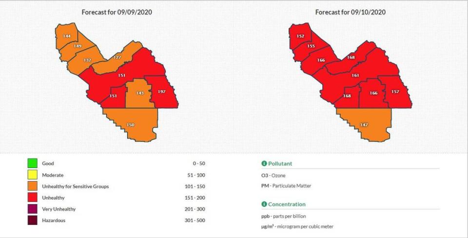
Earlier this week, the air district renewed a health caution for air quality due to smoke from the Creek Fire, noting winds were expected to blow smoke directly into the Valley, causing increased particulate matter pollution and potential high levels of ozone.
Particulate matter pollution can trigger asthma attacks, aggravate chronic bronchitis and increase the risk of heart attack and smoke, the air district reports. Young children, older people and those with existing respiratory conditions, including COVID-19, are especially susceptible to the health effects from this type of pollution.
The air district advised residents in the poor air quality areas to remain indoors and in a filtered, air-conditioned environment with closed windows.

