RI shoreline access: CRMC is moving forward with Portsmouth rights of way; others studied
A subcommittee of the Coastal Resources Management Council voted on Tuesday to move forward with the process of designating five rights of way to the shoreline in Portsmouth.
But the thornier matter of potential rights of way in Weekapaug, Narragansett, and the Buttonwoods section of Warwick will require further research, said the council's attorney, Anthony DeSisto.
The public access points under consideration in Portsmouth are located at 1 Beach St., Cedar Avenue, and Fountain Avenue in Island Park; at the end of Cory's Lane between Green Animals and the Portsmouth Abbey School; and at the end of East Power Street, which runs down to the Sakonnet River in a neighborhood just slightly north of Clements' Marketplace.
Discrepancy with Portsmouth public access points
Oddly, several already have signs labeling them as CRMC rights of way, DeSisto said. But a review of the CRMC's records showed that they never actually received that designation.
Political Scene: How can shoreline access in Rhode Island be improved? Candidates weigh in
DeSisto said Portsmouth's town planner became aware of the discrepancy and "has done quite a bit of work" to demonstrate that the access points should have that official designation, so that access will be protected if issues arise in the future.
"What he said is, basically, everyone uses these as rights of way," DeSisto said. "But we want to make sure they are officially designated as such."
Roger Williams University law students who are helping the CRMC to establish new rights of way "did a lot of legwork" to gather the necessary documentation, DeSisto said.
The panel unanimously approved DeSisto's recommendation to hold a public hearing where residents can weigh in on the proposed rights of way, which is typically the final step before the rights of way subcommittee holds a vote and forwards its recommendation to the full council.
Several other closely watched efforts to formally establish public rights of way along contested parts of the coastline remain on hold for now.
Narragansett shoreline access
One is the so-called "Mumford Road right of way" in Narragansett, a path near the William C. O'Neill bike path that leads to the Narrow River and has long been used as a kayak launch. In recent years, residents have reported encountering "No Trespassing" signs and other obstructions.
DeSisto said there was some confusion over whether the right-of-way had been accepted by the town of Narragansett along with the rest of the subdivision plat in 1965.
Narragansett: Council wants survey to look for encroachment on shoreline rights of way
"We did our research on it, but I really feel we’re going to have to do a bit more before it can be recommended for a public hearing," he said.
The subcommittee unanimously approved DeSisto's recommendation to hold off and conduct more research in the town's archives.
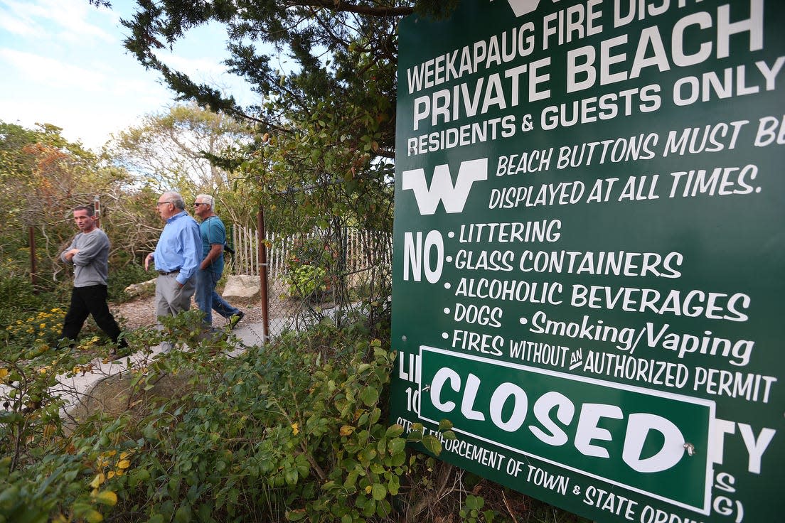
Potential rights of way in the Buttonwoods section of Warwick and the Weekapaug section of Westerly also will require further study, DeSisto said.
Weekapaug effort to block public access
In Westerly, a group of volunteers is making the case that the Weekapaug Fire District is illegally blocking a right of way called the "Spring Avenue Extension" in order to keep the public from using its beach.
Both sides have produced "very lengthy" memos outlining their legal arguments, DeSisto said. He acknowledged there was "a lot of public interest" and requested more time to analyze those memos and "come up with the appropriate legal position" before scheduling a public hearing.
Westerly: Armed with dusty old maps, activists fight to reclaim beach access in Weekapaug
Buttonwoods in Warwick maintains beach is private
DeSisto said there were "some similar issues" at play in Buttonwoods, where the Buttonwoods Fire District similarly maintains that it is a private beach community and its streets are not public rights of way.
In that case, there aren't any legal memoranda to comb through, but frequent fire district critic Richard Langseth has submitted quite a bit of research, DeSisto said.
Waterfront Warwick: Neighborhoods are full of 'No Parking' signs. Many aren't legal.
"What we do have is a lot of factual and historical data going back to the turn of the last century," DeSisto said. "We’re sorting through that too."
Tuesday also marked the launch of a new CRMC map that's intended to make it easier to find existing rights of way.
RI CRMC designated rights of way to the shore
Produced in collaboration with Save The Bay, the map plots the location of each right of way and has a gallery that contains recent photographs and relevant legal documentation.
It can be accessed by going to www.crmc.ri.gov/publicaccess.html and clicking on the ArcGIS online map.
Providence: Neighbors scramble to soften impact of waterfront apartments
This article originally appeared on The Providence Journal: RI beach access: CRMC discusses Portsmouth, Narragansett, Weekapaug

