Crooks Fire: Over 9,100 acres scorched; 27% contained
The Crooks Fire burning near Mount Union, about 10 miles south of Prescott, grew to 9,196acres and 27% containment as of Thursday night.
The fire was reported on April 18, and the cause is still under investigation, according to Inciweb, a website that tracks wildfire information.
The Yavapai County Sheriff's Office updated areas under evacuation and "set" status Tuesday evening. "Set" is the middle step of the state's three-step evacuation framework and advises residents to be ready to evacuate if ordered by authorities.
The following areas are under "go" or evacuation status:
Mountain Pine Acres
Breezy Pines
Potato Patch
South Walker
Lookout Mountain
Mount Tridal
Prescott National Forest announced that the restricted area expanded Wednesday night to the south and southeast of Prescott. The restrictions will be in place until May 3. A map of the updated restricted area can be found on the national forest's website.
The Prescott National Forest tweeted Tuesday afternoon that a community meeting is scheduled for 6 p.m. Thursday at Embry Riddle University for an update on the fire. The meeting will also be live-streamed on the Prescott National Forest's Facebook page.
#CrooksFire
A community meeting will be held Thursday, April 28th, 2022, at 6:00 p.m., at Embry Riddle University in the Hanger, 3700 Willow Creek Dr., Prescott, Arizona. The meeting will be live-streamed to the Prescott National Forest Facebook. pic.twitter.com/A32SmMlNjL— Prescott NF (@PrescottNF) April 26, 2022
Fire outlook and smoke forecast
Critical fire conditions were predicted Thursday due to gusty winds combined with low humidity. The low humidity will stay but winds will lighten on Friday.
Map: Here's where Arizona wildfires are burning
Smoke from the fire is expected to start to the south and spread to the north and northeast again Thursday, according to the Arizona Department of Environmental Quality. Prescott and Prescott Valley will continue to see smoke overhead. Flagstaff may also see light smoke in the afternoon.
About 879personnel were working on the fire as of Thursday morning.
On Wednesday, strong winds with low humidity hindered firefighting efforts, according to an update from Inciweb. Winds spread the fire west of Lookout Mountain towards Dosoris Canyon. Crews also worked south of Lookout Mountain with the support of aircraft.
Firefighters strengthened containment lines and structure protection Thursday.
"They're making good progress it's just really slow going. It's an active piece of fire, so we anticipate we will be able to grab this in the next couple days," said Kyle Jacobson, Operations Section Chief during a community meeting held Thursday.
Jacobson said despite the difficult terrain and conditions, the firefighters are "making great progress and doing everything they can."
Only two structures have been reported damaged since Monday, but additional information will be released when property locations have been verified and owners have been notified, forest officials said.
Tunnel Fire updates: Strong winds raise red flag warning
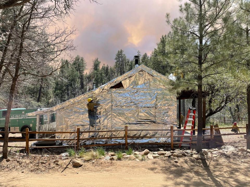
The U.S. Forest Service said fire crews wrapped Palace Station Historic Stagecoach Stop Cabin in a foil-like wrap designed to reflect heat away from the structure and cleared brush and low-hanging branches near it. The cabin is located in Crooks Canyon roughly 17 miles south of Prescott.
Where is the Crooks Fire burning?
Crooks Fire is burning about 10 miles south of Prescott in the west portion of Prescott National Forest, west of Big Bug Mesa, northwest of Pine Creek, southeast to Mount Tritle, south of Potato Patch and east of Johnson Flat.
The fire has reached Mount Union, Mount Davis, Yankee Doodle Peak and Moscow Peak. It also reached Lookout Mountain towards the west.
The Forest Service closed sites in Groom Creek and Lynx Lake recreation areas, White Spar campground, Prescott Circle Trail and the Prescott Basin on April 21. A full list of what is closed can be found on the Forest Service's website.
Evacuations in effect for Crooks Fire
People evacuated from Walker Road north of mile marker 10 and west of Big Bug Mesa were allowed to return home starting Monday at 3 p.m. The area will remain in "set" status, however. A full list of streets where residents can return was posted on Facebook.
The following areas are under evacuation or "go" status, according to the Yavapai County Sheriff's Office:
Mountain Pine Acres
Breezy Pines
Potato Patch
South Walker
Lookout Mountain
Mount Tridal
The following areas are under "set" status, meaning residents should be ready to evacuate:
Groom Creek
Walker North
Ponderosa Park
Pine Flat
Poland Road South
The American Red Cross said a shelter was set up for residents affected by the fire at the Yavapai College gymnasium, at 1100 E. Sheldon St. in Building 2, in Prescott.
If anyone has questions or needs assistance, they can stop by or call 1-800-RED-CROSS (800-733-2767).
Reach breaking news reporter Angela Cordoba Perez at Angela.CordobaPerez@Gannett.com or on Twitter @AngelaCordobaP.
Support local journalism. Subscribe to azcentral.com today.
This article originally appeared on Arizona Republic: Crooks Fire: Over 9,000 acres scorched; 27% contained
