'We are at the crosshairs': Guam braces for direct hit from Super Typhoon Mawar
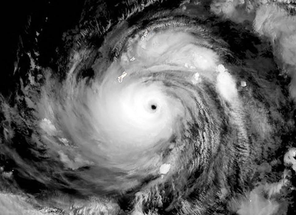
The 170,000 residents of U.S. territory Guam in the West Pacific were bracing Tuesday for a hit from Super Typhoon Mawar, which is now a Category 4 storm with winds of 155 mph.
Meteorologists say the typhoon could be the strongest in decades to impact Guam, bringing life-threatening flooding and the potential for damaging winds over the next few days.
President Joe Biden on Tuesday approved an emergency declaration for Guam as the storm approached. Guam Gov. Lou Leon Guerrero said on social media that the declaration will support the mobilization of resources into Guam, which is "especially crucial given our distance from the continental U.S."
"Current forecasts are not favorable to our island," Leon Guerrero said. "We are at the crosshairs of Typhoon Mawar. Take action now, stay calm, stay informed and stay safe."
The U.S. military also sent away ships as the storm approached. Guam is a crucial hub for U.S. forces in the Pacific, and the Department of Defense controls about a third of the island. All ships were moved out to sea as a standard precaution, according to the Navy, and any personnel remaining on the island were sheltering in place. About 6,800 U.S. service members are assigned to Guam, according to the Pentagon.
If Guam doesn’t take a direct hit, it will be very close, said Patrick Doll, the lead meteorologist for the National Weather Service in Tiyan, Guam.
When is hurricane season?: Here's when hurricane season starts and what to expect in 2023
#Mawar is now a super #typhoon with max winds of 155 mph - the strongest western North Pacific typhoon in May since Dolphin (2015). Mawar is looking likely to make a direct hit on Guam. pic.twitter.com/iHt78TgI9C
— Philip Klotzbach (@philklotzbach) May 23, 2023
Shelters start to fill in Guam
Authorities on the island territory warned anyone not living in a fully concrete house — some homes are made of wood and tin — to head to safety elsewhere, and emergency shelters began to fill as residents braced for the arrival of Mawar. Leon Guerrero also ordered residents in coastal, low-lying, and flood-prone areas to evacuate to high elevations.
Landon Aydlett, a meteorologist with the National Weather Service in Guam, said the typhoon's center was about 75 miles southeast of the island and was moving north-northwest by late morning time on Wednesday.
As rain from the storm's outer bands fell over the island, Mawar had maximum sustained winds of 140 mph with gusts peaking at 170 mph, Aydlett said.
One weather model forecast shows the eye of Mawar going directly over Guam, according to meteorologist Ryan Maue. "Regardless of a direct passage, the impacts will be extreme, equivalent to a Category 5 hurricane," Maue tweeted Tuesday.
The last Category 5 to make a direct hit in Guam was Super Typhoon Karen in 1962.
What's the difference between a hurricane and a typhoon?
A typhoon is the same type of storm as a hurricane. They are both tropical cyclones. The only difference between a hurricane and a typhoon is the location where the storm occurs, according to the National Ocean Service.
Typhoons form in the western Pacific Ocean, while hurricanes form in the eastern Pacific Ocean and the Atlantic Ocean.
What is a 'super' typhoon?
A typhoon becomes a "super" typhoon when its maximum sustained winds reach 150 mph. That's equivalent to a strong Category 4 hurricane on the Saffir-Simpson scale of hurricane intensity.
It's almost hurricane season. Here's the list of names for the 2023 Atlantic hurricane season.
'Extensive to severe damage' possible
The weather service in Guam said Mawar was likely to cause "considerable damage to buildings and homes of light material. Extensive damage to non-concrete roof(s). Non-reinforced concrete walls could be blown down.
"Severe damage to well-built wooden and metal structures possible. Some reinforced hollow-spun concrete power poles and many reinforced wooden power poles could be downed. Solar panels could be damaged."
Guam is no stranger to typhoons
Guam and the nearby Northern Mariana Islands are no strangers to typhoons, said meteorologist Jeff Masters of Yale Climate Connections. According to the NOAA historical hurricane tracks website, during the 50-year period 1972-2021, "66 typhoons of category 1 or higher strength passed within 50 miles of the islands," Masters said.
"However, only six of these have occurred before June 1; four of these were of category 3 or higher strength. Thus, Typhoon Mawar is an unusually early typhoon for the islands," Masters said.
Where is Guam located?
Guam is a U.S. island territory located in the Micronesia region of the western Pacific Ocean, nearly 3,800 miles west of Honolulu. Its residents are U.S. citizens, but they cannot vote for president and do not have a voting member in Congress.
Contributing: The Associated Press
This article originally appeared on USA TODAY: Guam braces as Super Typhoon Mawar closes in for direct hit

